
 Worksheets
Revision quiz
Total questions: 35
Worksheet time: 16mins
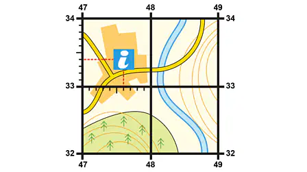
What is the six figure grid references for the Information Centre?
476,334
336,474
476,344
486,334
What is the four figure grid references for the Information Centre?
47,33
33,47
47,34
48,33

Which direction is Mansergh from Old Town?
North
South East
South West
North

What Kind of map is this?
Political Map
OS map
Physical Map
Population Map

What do contour lines show on a map?
Where the rivers are.
How urban a place is
How rural a place is.
The height and shape of the land.
What lines show the height and shape of the land?
(a)

How do we measure distance on a map?
Compass Rose
A Scale Line
A ruler
Contour Lines
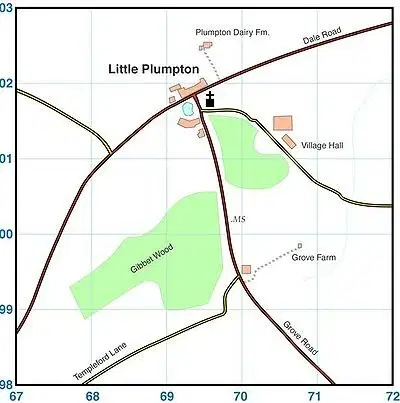
If I wanted to travel from the church to the village hall, which direction would I travel in?
North
South East
North West
East
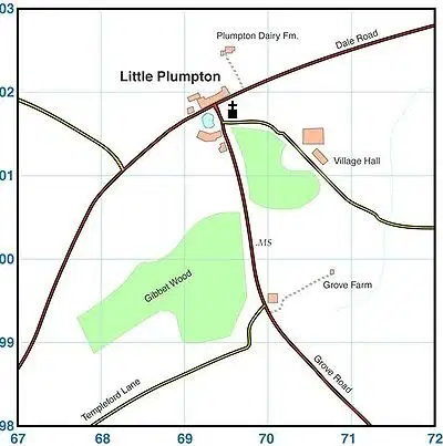
If I wanted to travel from Grove Farm to the Village Hall, what direction would I travel in?
North
East
South
West

What is the four figure grid reference for the church with a tower?
01,69
69,01
69,02
70,01

What is the six figure grid reference for the church with a tower?
691,013
017,696
696,017
696,027
Match the following

School

Information Centre

Church with a spire

Castle

Picnic Area

What is the name of the sea to the East of the UK?
English Channel
Celtic Sea
Atlantic Ocean
North Sea
What is the name of the sea to the South East of the UK?
English Channel
Celtic Sea
Atlantic Ocean
North Sea
Label the oceans.
Pacific (West)
Arctic
Atlantic
Indian
Southern
Pacific (East)
Label the Map
Ireland
England
Scotland
Wales
Northern Ireland
Label the Map of capital cities
London
Edinburgh
Cardiff
Belfast
Label the world map with the correct continents
Australasia
Europe
Antarctica
Asia
Africa
North America
South America
What does relief mean?
The height and shape of the land.
The land is mountainous.
The land is flat.
The land is steep.
What does sustainability mean?
Being kind
Meeting the needs of today without thinking about the needs of tomorrow
Meeting the needs of today without compromising the needs of the future
Meeting the needs of the future without thinking about the needs of today
Which are the three types of Geography? (Tick 3 )
Human
Physical
Sustainability
Environmental
An example of human geography is (a)
An example of physical geography is (a)
An example of environmental geography (a)

Which direction is this hill at its steepest?
North side
East side
South side
West side?
What does urban mean?
The countryside
Refers to towns and cities
Big wide open spaces
Refers to mountains
What is the difference between Great Britain and United Kingdom?
The United Kingdom includes Northern Ireland and Great Britain does not.
There is no difference
The United Kingdom includes Scotland and Great Britian does not
Great Britain Includes Northern ireland and the United Kingdom does not.
What are the four nations of the United Kingdom?
England, Scotland, Wales and Ireland
England, Scotlans, Wales and Belfast
ENgland, Scoltalnd, Wales and Northen Ireland
England, Wales, Irealnd and Northern Scotland
What is the capital of Northern Ireland?
Dublin
Belfast
Cardiff
Edinburgh
What is the capital of Wales?
Cardiff
Edinburgh
Belfast
Swansea
What is the capital of Scotland?
What is the capital of England?
What is the name of the sea to the South East of the UK?
English Channel
Celtic Sea
Atlantic Ocean
North Sea
What is the name of the sea inbetween Wales and Ireland?
English Channel
Irish Sea
Atlantic Ocean
North Sea
Label the compass rose
North West
South West
South East
North East
North
East
South
West

