wayground logo

Free Printable Worksheets

Font size

S
M
L
XL
Worksheets

Arabia, Africa, China, Europe Geography Quiz

Total questions: 43

Worksheet time: 36mins

Name
Class
Date
1.

Name location # 1

a)

Constantinople

b)

Rome

c)

Gaul

d)

Britain (England)

2.

Label # 8

a)

Aegean Sea

b)

Mediterranean Sea

c)

Baltic Sea

d)

Red Sea

3.

What was the capital city of the Byzantine Empire?

a)

Rome

b)

Constantinople

c)

Athens

d)

Istanbul

4.

Which statement best describes the strategic location of Constantinople?

a)

It was located on an island and therefore free from invasions.

b)

It bordered the Mediterranean Sea.

c)

It was close to the city of Rome.

d)

It was located at the crossroads of the Asian and European continents.

5.

Oasis

a)

a prolonged period of abnormally low rainfall, leading to a shortage of water

b)

a dry, barren area of land, especially one covered with sand, waterless, and without vegetation

c)

dry and shriveled

d)

an area in the desert where fresh water is available, and plants grow

6.

The Arabian Peninsula is located between which CONTINENTS?

a)

Europe

b)

Africa

c)

Asia

d)

South America

e)

North America

7.
The region of Africa with open grasslands and scattered trees is the
a)
Sahara
b)
Sahel
c)
Savanna
d)
Rainforest
8.

The main river that West African empires started around:

a)
Nile
b)
Niger
c)
Volta
d)
Tigris
9.
Salt was a biologically important mineral found where in Africa?
a)
Northern Sahara desert
b)
the rainforest
c)
Zimbabwe
d)
the sahel
10.
A semi-dry strip of land in Africa that divided the desert from wetter lands to the south
a)
Sahara
b)
Sahel
c)
Savanna
d)
Rainforest
11.

The main geographic feature of the Arabian peninsula is

a)

Mountains

b)

Deserts

c)

Plains

d)

Volcanoes

12.
birthplace of Muhammad; Muslims are required make a pilgrimage to this city once in their life

a)
mecca
b)
medina
c)
memphis
d)
judaism
13.

Which body of water is located at point 1?

a)

Red Sea

b)

Persian Gulf

c)

Black Sea

d)

Mediterranean Sea

14.

Which body of water is located at point 2?

a)

Red Sea

b)

Persian Gulf

c)

Black Sea

d)

Mediterranean Sea

15.

Which body of water is located at point 3?

a)

Red Sea

b)

Tigris River

c)

Arabian Sea

d)

Mediterranean Sea

16.

Which body of water is located at point 4?

a)

Persian Gulf

b)

Tigris River

c)

Arabian Sea

d)

Mediterranean Sea

17.

Which body of water is located at point 5?

a)

Black Sea

b)

Caspian Sea

c)

Mediterranean Sea

18.

Which body of water is located at point 6?

a)

Black Sea

b)

Caspian Sea

c)

Arabian Sea

d)

Mediterranean Sea

19.

What landform is at point G?

a)

Europe

b)

Asia

c)

India

d)

Arabia

20.

What city is located at point A?

a)

Constantinople

b)

Rome

c)

Byzantium

d)

Mecca

21.
What desert is located at number 1? 
a)
Sahara 
b)
Sahel 
c)
Kalahari 
d)
Nile 
22.
Feature #3
a)
Atlantic Ocean
b)
Indian Ocean
c)
Southern Ocean
d)
Pacific Ocean
23.

What physical feature are the arrows pointing to

a)

Black Sea

b)

Caspian Sea

c)

Mediterranean Sea

d)

Atlantic Ocean

24.

Name location # 1

a)

Constantinople

b)

Rome

c)

Gaul

d)

Britain (England)

25.
Who moved the capital of Rome to Byzantium and renamed it "New Rome" (later Constantinople)?
a)
Justinian
b)
Constantine 
c)
Charlemagne
d)
Leo III
26.
What was the capital city of the Byzantine Empire? 
a)
Rome 
b)
Athens 
c)
Constantinople 
d)
Italy 
27.

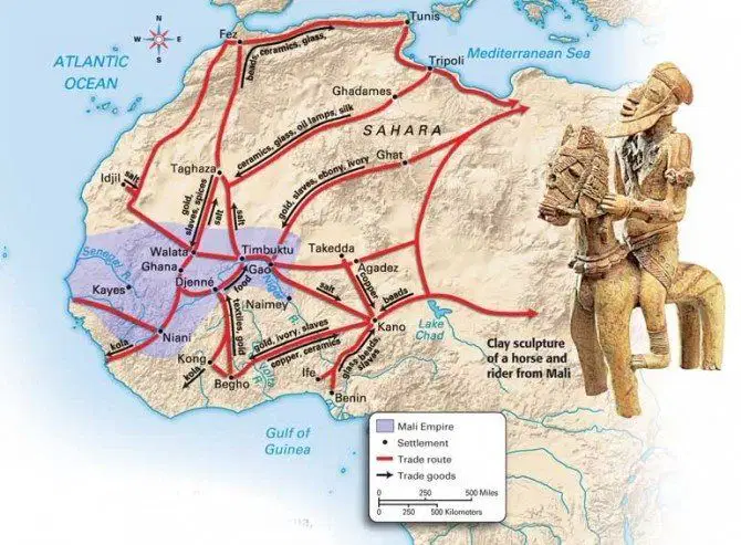
Where in the world is this? What is depicted by the red lines on this map?

a)

Eygpt: the Exodus

b)

India: East India Company trade route

c)

Eurasia: the Silk Road

d)

Africa: The trans -Saharan trade

28.

What city was a major trade center in Africa?

a)

Tripoli

b)

Alexandria

c)

Timbuktu

d)

Mesopotamia

29.

The trading network in Africa also spread ____________ south of the Sahara.

a)

Gold

b)

Christianity

c)

Islam

d)

Iron

30.

12- the orange star=

a)

Timbuktu

b)

Djenne

c)

Mecca

d)

Mali

31.

5=

a)

Mediterranean Sea

b)

Gulf of Guinea

c)

Red Sea

d)

Atlantic Ocean

32.
The area in red is an elevated area in China where most of the country's rivers originate from. What's it called?
a)
Gobi Desert
b)
Taklamakan Desert
c)
Plateau of Tibet
d)
Himalayas
33.
What river is the arrow pointing at?
a)
Yangtze 
b)
Huang He
c)
Amazon
d)
Mississippi
34.
What mountain range is located in southern China?  (hint: it runs along the border between China and India) In the area of the arrow is pointing.
a)
Rockies
b)
Ozark
c)
Himalayan
d)
Alps
35.
This river is the longest in Asia and was often used for transportation in China.
a)
Gobi
b)
Yangtze
c)
Huang He
d)
Ohio
36.
This desert lies in both China and Mongolia.  It is also known as a cold desert.
a)
Gobi
b)
Taklamakan
c)
Kalahari
d)
Sahara
37.
What river is pictured?
a)
Tennessee
b)
Danube
c)
Yangtze
d)
Yellow
38.
What were the two major rivers of Ancient China?
a)
Yellow and Yangtze
b)
Nile and Euphrates
c)
Yellow and Red
d)
Yangtze and Himalaya
39.
How was Chinese civilization affected by mountains and deserts?
a)
They became wealthy.
b)
They were isolated from other civilizations.
c)
They made it easier to travel.
d)
They made China easy to be attacked.
40.
a river in china also known as the Yellow River; flows from Mongolia to the Pacific Ocean
a)
Dao
b)
Zhou
c)
Shang
d)
Huang He
41.

Where was the Great Wall located?

a)

Along the western border

b)

Along the southern border

c)

Along the northern border

d)

Along the ocean to the east

42.

What man made feature connected south and north China?

a)

Great Aqueduct

b)

Grand Canal

c)

Great Wall of China

43.

What major construction project by the Sui Dynasty connected China's two main rivers and improved transportation?

a)

Transcontinental Railroad

b)

Silk Road

c)

The Great Dam

d)

Grand Canal