
 Worksheets
World Geography SOL Review 3
Total questions: 18
Worksheet time: 9mins
Name
Class
Date
1.

Which number on the map is closest to the Pyrenees Mountains?
a)
1
b)
2
c)
3
d)
4
2.
Which of these physical characteristics are LEAST LIKELY to be found in a geographic area known as a "steppe"?
a)
limited rainfall
b)
cold winters
c)
grasslands
d)
dense forests
3.

This map shows where major cities in Russia are located. Based on the map, which of these is MOST LIKELY true?
a)
The eastern portion of the country is home to major industrial centers.
b)
All of the major cities are close to the Russian capital.
c)
Most of Russia's population is concentrated in western cities.
d)
Russia's climate is influenced by the Pacific Ocean.
4.
Which religion is most prominent across Turkmenistan, Uzbekistan, and Tajikistan?
a)
Hinduism
b)
Buddhism
c)
Catholic Christianity
d)
Islam
5.
From 2001 to 2009, the U.S. film industry has greatly increased distribution and profits in countries such as Russia, China, and Brazil. Which statement best explains this trend?
a)
American films are more popular abroad than in domestic markets.
b)
American studios adopt the techniques used to create foreign films.
c)
American culture in films has widespread appeal in many societies.
d)
American movie producers control the influence of films on culture.
6.
-Small continent
-Extensive railroad connections
-Integrated highway systems
The interrelationship of the factors above is most responsible for the-
a)
frequent wars between European nations.
b)
elimination of language differences across Europe.
c)
creation of military checkpoints throughout Europe.
d)
easy exchange of goods among European cities.
7.
*Railroads
*Highways
*Airplanes
These modes of transportation have affected where economic activities are conducted throughout the world by-
a)
requiring more population centers to develop near natural resources.
b)
enabling productive regions to be less dependent on long-distance trade.
c)
making access to water routes near settlements less necessary.
d)
encouraging private businesses to invest more in the development of public infrastructure.
8.
Which statement best explains how Jerusalem is perceived throughout the world?
a)
Foreign students regard it an intellectual center for higher education.
b)
Several countries claim it as a colonial possession.
c)
Economists view it as an important center for international trade.
d)
The adherents of several major world religions regard it as a holy city.
9.
The arrival of new immigrant groups creates a more diverse culture when -
a)
immigrants are pressured to assimilate quickly to their new community
b)
immigrants are forced to settle in areas populated by people from their homeland
c)
the traditions of local and immigrant populations combine to create new customs
d)
local governments pass laws enforcing immigration quotas
10.
One argument in favor of using genetically modified crops is that doing so-
a)
protects biological diversity on cultivated land.
b)
reduces the use of pesticides on crops.
c)
allows for the cultivation of native food sources.
d)
guarantees high yields of cash crops.
11.
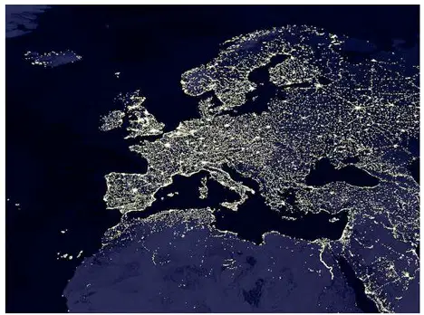
Satellite image of Europe by night, NASA 2005.
Which statement is the BEST summary about the population of Europe as shown in this image?
a)
Europe has a greater population than the visible areas of Africa, Asia or the Middle East.
b)
Europe's population is centered most heavily on its southern coastline.
c)
The economies of Europe are able to produce nuclear energy.
d)
Europe's population is centered most heavily along its mountain ranges and the interior of the continent.
12.
Which climate best characterizes the high latitudes?
a)
tropical
b)
subarctic
c)
humid continental
d)
marine west coast
13.

This map supports the conclusion that malnutrition is most likely to occur in which country?
a)
Peru
b)
Brazil
c)
Bolivia
d)
Argentina
14.
Why is the Colorado River Basin unable to meet the water needs of states in the Southwest?
a)
Urban areas developed rapidly.
b)
Heavy rainfalls led to erosion of earthen dams.
c)
Chemical spills contaminated farm areas.
d)
Reservior surfaces evaporated.
15.

This type of map is used to show -
a)
elevation
b)
population
c)
natural resources
d)
politcal boundaries
16.
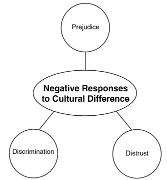
What would be the best way to improve relations among people in the community represented in the graphic below?
a)
laws that require people to follow the customs of the majority
b)
regulations that restrict certain groups from moving into an area
c)
policies that set aside separate spaces where each ethnic group can live
d)
events that bring people together to learn about the traditions of other groups
17.
What is a common characteristic of these physical regions?
*Pampas in South America
*Steppes in Mongolia
a)
They are desert areas used for mining resources.
b)
They are grasslands that support raising livestock.
c)
They are taigas that provide valuable wood products.
d)
They are rain forests used to harvest medicines.
18.
Which statement about the culture of Latin America is most accurate?
a)
The land is evenly distributed among all citizens.
b)
Public education is widespread and open to all.
c)
Roman Catholicism is the common religion.
d)
The French language has an impact on local customs.
100 %

