
NEW
Font size
 Worksheets
13 Colonies & Physical Features
Total questions: 25
Worksheet time: 17mins


Which colony is marked on the map with a #1?
New York
Massachusetts
New Hampshire
Rhode Island
Which colony is marked on the map with a #2?
New York
Massachusetts
New Hampshire
Rhode Island
Which colony is marked on the map with a #3?
New York
Massachusetts
New Hampshire
Rhode Island
Which colony is marked on the map with a #4?
New York
Massachusetts
New Hampshire
Rhode Island

Which colony is labeled on the map with #5?
Connecticut
Pennsylvania
New Jersey
Delaward
Which colony is labeled on the map with #6?
Connecticut
Pennsylvania
New Jersey
Delaware
Which colony is labeled on the map with #7?
Connecticut
Pennsylvania
New Jersey
Delaware
Which colony is labeled on the map with #8?
Connecticut
Pennsylvania
New Jersey
Delaware

Which colony is labeled on the map with #9?
Maryland
Virginia
North Carolina
South Carolina
Georgia
Which colony is labeled on the map with #10?
Maryland
Virginia
North Carolina
South Carolina
Georgia
Which colony is labeled on the map with #11?
Maryland
Virginia
North Carolina
South Carolina
Georgia
Which colony is labeled on the map with #12?
Maryland
Virginia
North Carolina
South Carolina
Georgia
Which colony is labeled on the map with #13?
Maryland
Virginia
North Carolina
South Carolina
Georgia
The large river that forms a border between the US and Mexico

Brooks Range
Missouri River
Ohio River
Rio Grande


Which of the Great Lakes is highlighted?
Lake Michigan
Lake Ontario
Lake Huron
Lake Erie

Which of the Great Lakes is highlighted?
Lake Superior
Lake Ontario
Lake Michigan
Lake Erie

Which of the Great Lakes is highlighted?
Lake Superior
Lake Huron
Lake Michigan
Lake Erie

Which of the Great Lakes is highlighted?
Lake Superior
Lake Huron
Lake Ontario
Lake Erie

Which of the Great Lakes is highlighted?
Lake Michigan
Lake Huron
Lake Ontario
Lake Superior
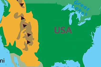
Which physical feature is highlighted on the map? (In orange)
Rocky Mountains
Appalachian Mountains
Mississippi River
Great Plains

