wayground logo

Free Printable Worksheets

Font size

S
M
L
XL
Worksheets

6th Grade Ch 05 Info Study Guide: The United States

Total questions: 28

Worksheet time: 14mins

Name
Class
Date
1.

Having an adequate water supply is one of the major challenges for what region of the United States? (Ch 5)

a)

West

b)

South

c)

Midwest

d)

Northeast

2.
Why has the number of many small family farms in the western states declined? (Ch 5)
a)
They have been replaced by agribusinesses.
b)
The land is very poor and not suitable for farming.
c)
There is no longer enough water to raise crops.
d)
The farmers have decided to move to the cities.
3.
What do we know about locations of most major cities? (Ch 5)
a)
They are usually located near a waterway or a body of water.
b)
They are usually located near mountains.
c)
They are usually located near mines.
d)
They are usually located below east-facing mountains.
4.

Due to the rain shadow effect, valleys east of the Cascade and Sierra Nevada mountain ranges have what type of climate? (Ch 5)

a)

Arid

b)

Polar

c)

Temperate

d)

Mediterranean

5.
Due to the mild climate and booming businesses of the western United States, what has grown in the region? (Ch 5)
a)
population
b)
the water supply
c)
land area
d)
small family farms
6.
The United States exports the most goods to which two countries? (Ch 5)
a)
Brazil and Canada
b)
Mexico and Canada
c)
China and Canada
d)
Mexico and China
7.
What are four advantages of NAFTA (USMCA)? (Ch 5)
a)
Trade has tripled with the United States, Canada, and Mexico.
b)
Greater trade increased economic output
c)
U.S. oil imports from Mexico cost less because NAFTA got rid of tariffs.
d)
NAFTA lowered prices for consumers.
e)
Loss of US jobs to factories in Mexico.
8.
What are four disadvantages of NAFTA (USMCA)? (Ch 5)
a)
Loss of U.S. jobs.
b)
Kept wages low for American workers.
c)
The new factories harmed the environment of Mexico.
d)
NAFTA put Mexican farmers out of business.
e)
Increased trade between U.S., Mexico, and Canada.
9.
Over harvesting of lumber in the western United States contributed to what major environmental problem? (Ch 5)
a)
erosion
b)
desertification
c)
wildfires
d)
desalination
10.
During the 1950s, the U.S. and Canada built locks between the Great Lakes and into the St. Lawrence River, which are known as what? (Ch 4)
a)
the St. Lawrence Seaway
b)
the Erie Canal
c)
the Mighty Mississippi
d)
the Gulf Stream
11.
The United States is an example of a representative democracy. What is a representative democracy? (Ch 4)
a)
a form of democracy in which citizens elect people to represent them
b)
a form of government where a king or queen rule
c)
a form of government in which one person has all the power over everything
d)
a form of government led by a single party that enforces strict obedience in its rule
12.

What branch is NOT part of the United States' government? (Ch 4)

a)
Legislative Branch
b)
Representative Branch
c)
Executive Branch
d)
Judicial Branch
13.
Why is the Midwest nicknamed the nation’s breadbasket? (Ch 4)
a)
because many of the people who live in that area enjoy eating bread
b)
because that area is known for growing pine trees, which is used for basket making
c)
because a large amount of America’s crops are grown in its rich soil
d)
because many homes typically have baskets that family's keep their bread in
14.
What has caused the mountains in the Appalachian Mountain system to wear down over time? (Ch 4)
a)
glaciers
b)
earthquakes
c)
strong winds
d)
erosion
15.
What are the three largest metropolitan areas in the United States? (Ch 4)
a)
Detroit
b)
New York
c)
Los Angeles
d)
Chicago
16.
Into which river do the waters of the Great Lakes flow? (Ch 4)
a)
Ohio River
b)
Mississippi River
c)
St. Lawrence River
d)
Missouri River
17.
How were the Great Lakes formed? (Ch 4)
a)
These lakes were formed thousands of years ago when many rivers emptied into large holes in the ground.
b)
These lakes were formed thousands of years ago when a large thunderstorm dumped many loads of water in the area.
c)
These lakes were formed thousands of years ago when it was connected to the ocean.
d)
These lakes were formed thousands of years ago when massive glaciers carved out the ground and melted over time.
18.

What are the two MINOR climate zones of the contiguous United States? (Ch 4)
a)
Mediterranean
b)
Temperate
c)
Arid
d)
Mountains
19.
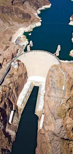
The photograph shows the Hoover Dam in Nevada. What benefits do dams like this one provide the western region of the United States? Select all that apply. (Ch 5)
a)
crop irrigation
b)
fossil fuels extraction
c)
hydroelectric power
d)
city water supply
20.
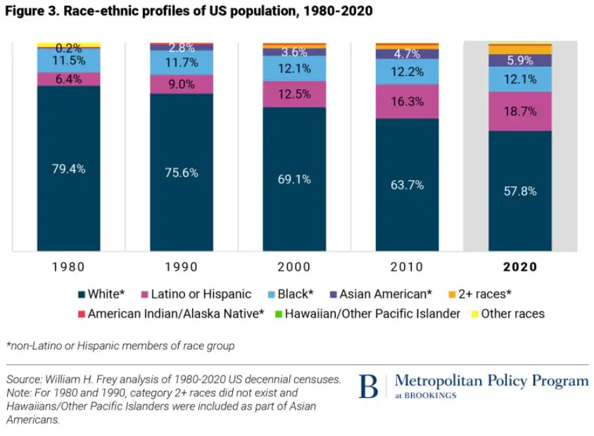
Based on the graph, which group was the second largest ethnic group in the United States in 2020? (Ch 4)
a)
Latino or Hispanic Americans
b)
Asian Americans
c)
Black Americans
d)
American Indians/Alaskan Natives
21.
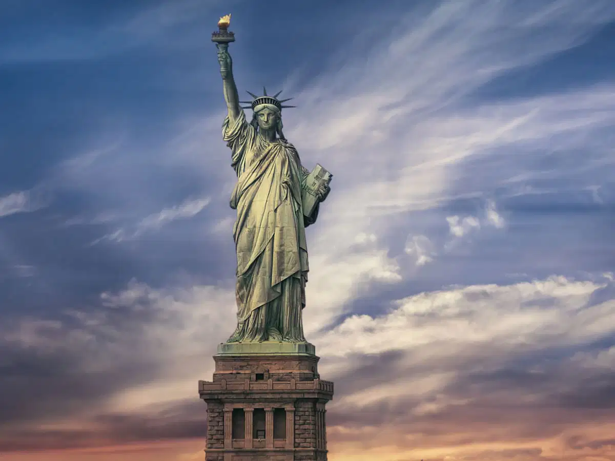
This statue was given to the United States by France in 1881 and is considered a symbol of freedom. What is the name of this statue, and where is it located? (Ch 4)
a)
Name: Statue of Liberty -- Location: New York City, New York
b)
Name: Mount Rushmore -- Location: Keystone, South Dakota
c)
Name: Statue of Liberty -- Location: Miami, Florida
d)
Name: Golden Gate Bridge -- Location: San Francisco, California
22.

joined together inside a common boundary

a)

tributary

b)

lock

c)

contiguous

d)

irrigation

e)

agribusiness

23.

the process of collecting water and using it to water crops

a)

tributary

b)

lock

c)

contiguous

d)

irrigation

e)

agribusiness

24.

an industry based on huge farms that rely on machines and mass-production methods

a)

tributary

b)

metropolitan

c)

contiguous

d)

irrigation

e)

agribusiness

25.

an area that includes a city and its surrounding suburbs

a)

tributary

b)

metropolitan

c)

contiguous

d)

irrigation

e)

agribusiness

26.

a smaller part of a region

a)

tributary

b)

metropolitan

c)

contiguous

d)

irrigation

e)

subregion

27.

a small river that flows into a larger river

a)

tributary

b)

metropolitan

c)

contiguous

d)

irrigation

e)

subregion

28.

a gated passageway used to raise or lower boats in a waterway

a)

tributary

b)

lock

c)

contiguous

d)

irrigation

e)

subregion