
 Worksheets
US History Winter Break Challenge
Total questions: 154
Worksheet time: 2hrs 33mins
Transports industrial and farm products to the Gulf of Mexico and is considered a
transportation artery.
Mississippi River
Missouri River
Colorado River
Columbia RIver
Known as the “Gateway to the West” because it helped settlers travel from the east to the
west.
Ohio River
Atlantic Ocean
Rio Grande River
Pacific Ocean
Many inland port cities were established along the shores of these bodies of water.
Great Lakes
Gulf of Mexico
St. Lawrence River
Missouri River
This is known as the “Highway for early explorers, settlers and immigrants.”
Atlantic Ocean
Pacific Ocean
Gulf of Mexico
Great Lakes
Forms a partial border between Eastern Canada and the state of New York.
St. Lawrence River
Great Lakes
Ohio River
Rio Grande River
This body of water was used by explorers and is known as “an early exploration route.”
Pacific Ocean
Atlantic Ocean
Gulf of Mexico
Mississippi River
The Spanish used this water route that flows from the Rocky Mountains into the Pacific.
Colorado River
Columbia River
Rio Grande River
Missouri River
Transportation artery carrying farm and industrial products into the Mississippi River.
Missouri River
Mississippi River
Gulf of Mexico
Columbia River
The western-most river explored by Lewis and Clark that flows from Canada to the Pacific.
Columbia River
Colorado River
Ohio River
Missouri River
The French and Spanish explored this body of water that connects to the Atlantic Ocean.
Gulf of Mexico
Great Lakes
St. Lawrence River
Ohio River
This body of water forms the border between Mexico and the United States and flows into
the Gulf of Mexico.
Rio Grande River
Mississippi River
Missouri River
Colorado River

Which body of water is being represented (in red) on the map?
Colorado River
Columbia River
Rio Grande River

Which body of water is being represented (in red) on the map?
Colorado River
Columbia River
Rio Grande River

Which body of water is being represented (in red) on the map?
Great Lakes
St. Lawrence River
Atlantic Ocean

Which body of water is being represented (in red) on the map?
Mississippi River
Missouri River
Ohio River

Which body of water is being represented (in red) on the map?
Mississippi River
Missouri River
Ohio River

Which body of water is being represented (in red) on the map?
Mississippi River
Missouri River
Ohio River

Which body of water is being represented (in red) on the map?
Columbia River
Colorado River
Rio Grande River

Which body of water is being represented (in red) on the map?
Ohio River
Great Lakes
St. Lawrence River
Which region can be described as rolling flatlands with many rivers, broad river valleys, and grassy hills?
Interior Lowlands
Great Plains
Coastal Plains
Canadian Shield
Which region has rugged mountains along the Pacific Coast that stretch from California to Canada; Contains fertile valleys?
Coastal Range
Basin and Range
Rocky Mountains
Appalachian Mountains
Which region can be described as flat grasslands that gradually increases in elevation westward?
Interior Lowlands
Great Plains
Coastal Plains
Canadian Shield
Which region is located along the Atlantic Ocean and Gulf of Mexico with broad lowlands providing many excellent harbors?
Interior Lowlands
Great Plains
Coastal Plains
Canadian Shield
Which region is wrapped around the Hudson Bay in a horseshoe shape with hills worn by erosion and hundreds of lakes carved by glaciers, and holds some of the oldest rock formations in North America?
Interior Lowlands
Great Plains
Coastal Plains
Canadian Shield
Which region has rugged mountains stretching from Alaska almost to Mexico with high elevations and contains the Continental Divide, which determines the directional flow of rivers?
Coastal Range
Basin and Range
Rocky Mountains
Appalachian Mountains
Which region extends from eastern Canada to western Alabama and includes the Piedmont with old, eroded mountains ?
Coastal Range
Basin and Range
Rocky Mountains
Appalachian Mountains
Which region is an area of varying elevations containing isolated mountain ranges and Death Valley (the lowest point in North America)?
Coastal Range
Basin and Range
Rocky Mountains
Appalachian Mountains
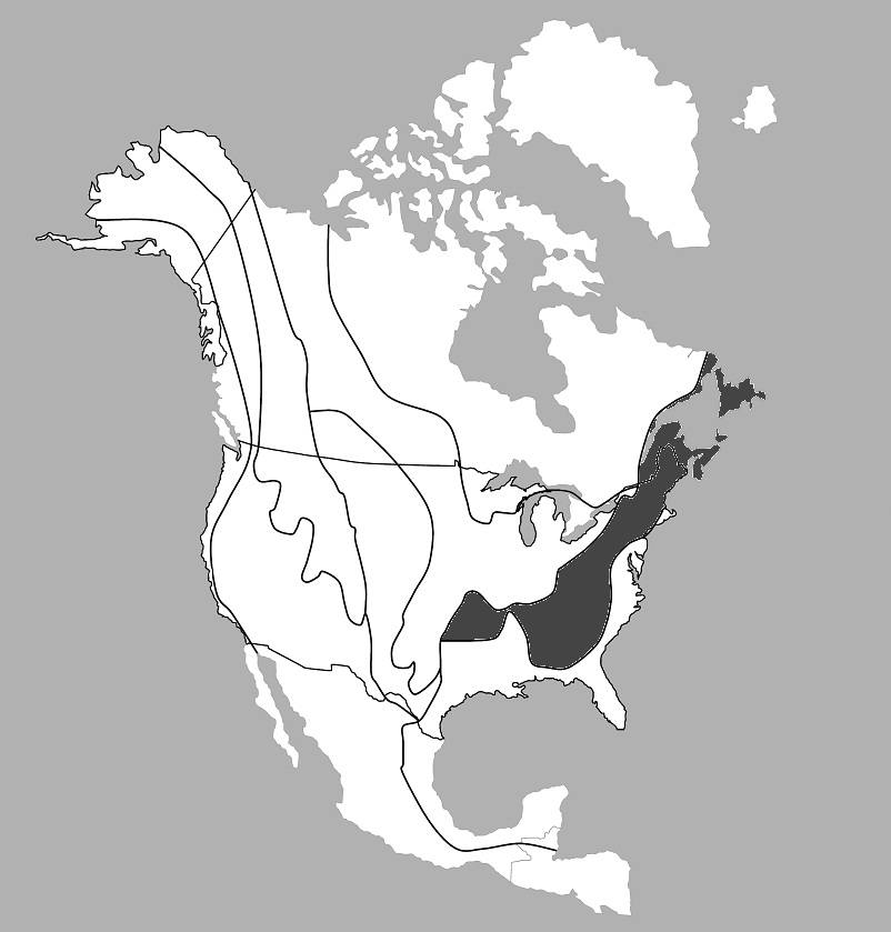
Which region is shaded in the map?
Coastal Range
Basin and Range
Rocky Mountains
Appalachian Mountains
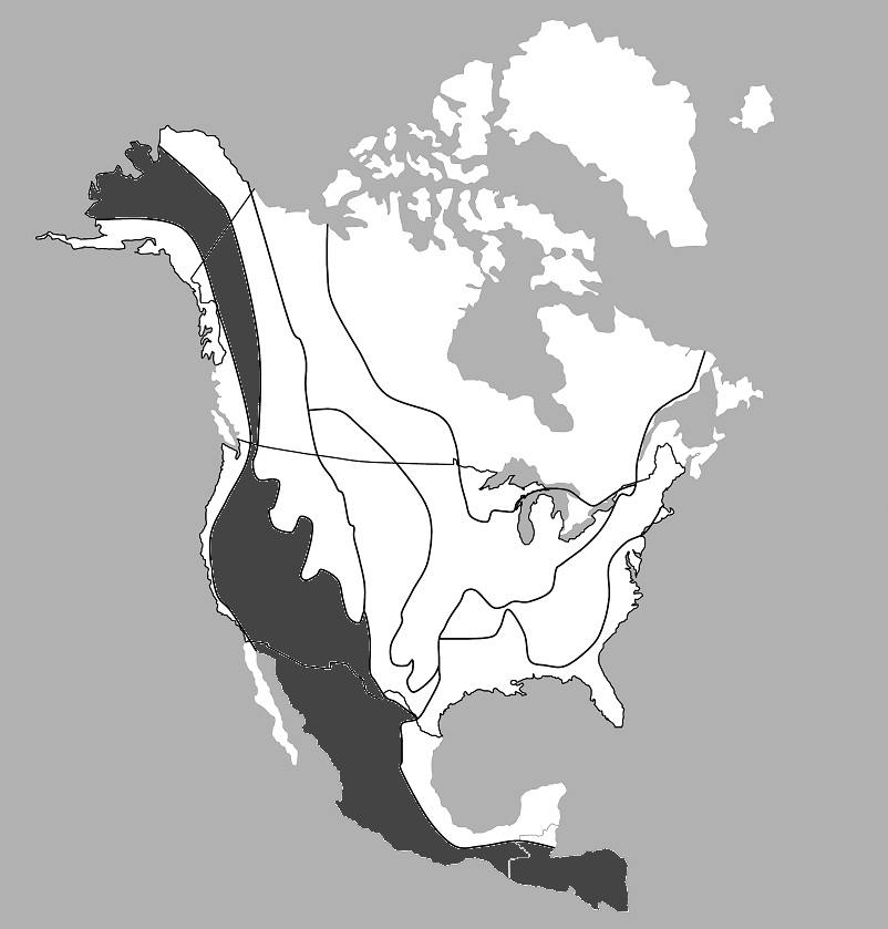
Which region is shaded in the map?
Coastal Range
Basin and Range
Rocky Mountains
Appalachian Mountains
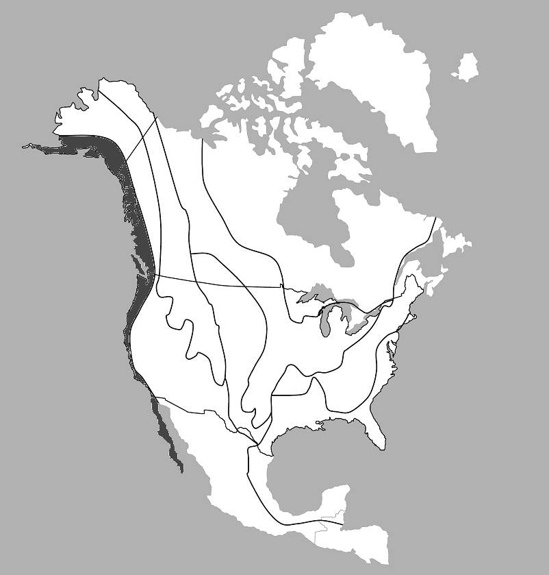
Which region is shaded in the map?
Coastal Range
Basin and Range
Rocky Mountains
Appalachian Mountains
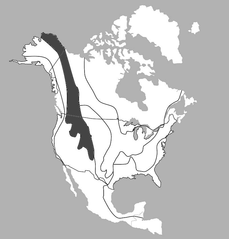
Which region is shaded in the map?
Coastal Range
Basin and Range
Rocky Mountains
Appalachian Mountains
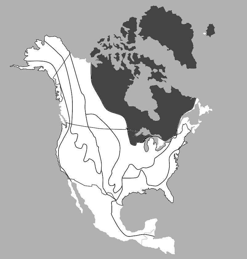
Which region is shaded on the map?
Interior Lowlands
Great Plains
Coastal Plains
Canadian Shield
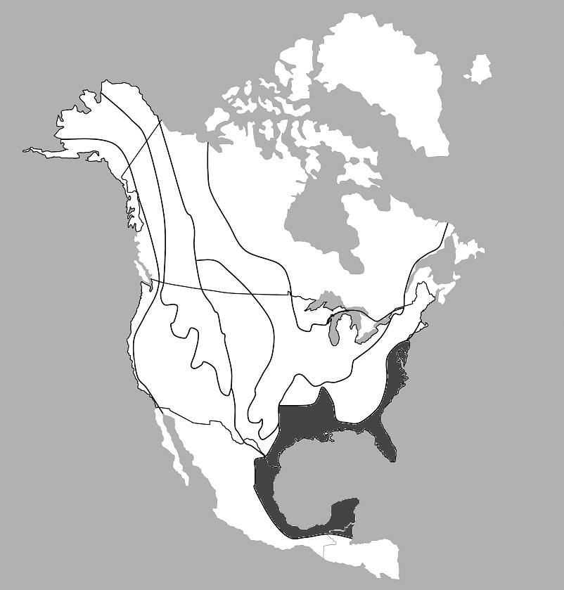
Which region is shaded on the map?
Interior Lowlands
Great Plains
Coastal Plains
Canadian Shield
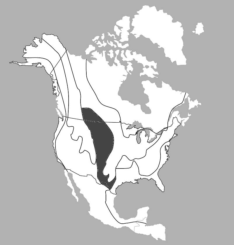
Which region is shaded on the map?
Interior Lowlands
Great Plains
Coastal Plains
Canadian Shield
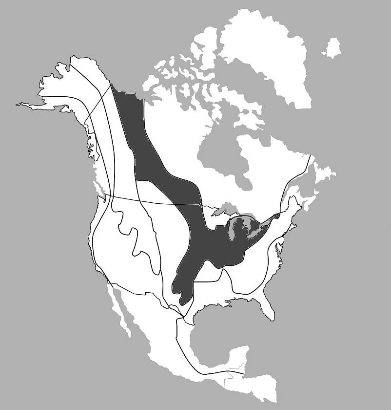
Which region is shaded on the map?
Interior Lowlands
Great Plains
Coastal Plains
Canadian Shield
The study of past cultures and human behavior through studying evidence left behind by people of the past is called ___.
sociology
anthropology
paleontology
archaeology
__________ is something made by humans and often is a primitive tool, structure, or part of a functional item.
An artifact
A natural resource
An archaeologist
A human resource
What do scientists disagree about?
Why people entered the Southern Hemisphere
When people entered North America
How people entered the United States
How and when people entered the Western Hemisphere
Cactus Hill is located in _______ Virginia.
Southeastern
Southwestern
Eastern
Southern
Cactus Hill is located near the ________ River.
Nottoway
James
Ohio
Mississippi
Why is Cactus Hill such a significant archaeological site?
The arrowheads discovered there are like none ever found before
Artifacts found there finally got scientists to agree on how and when people came to the Western Hemisphere.
It is not a significant site. Artifacts found here provided no new evidence
Evidence that humans lived there 15,000-18,000 years ago makes it one of the oldest archaeological sites in North America.
A person who studies human behavior and culture through the recovery and analysis of artifacts is called ___.
a scientist
an archaeologist
a paleontologist
a botanist
A ______ is an example of an artifact an archaeologist would use to study people of the past.
cooking pot
dinosaur bone
dirt
rock

Which tribe lived in the area shaded in grey on the map?
Inuit
Pueblo
Kwakiutl
Lakota

Which tribe lived in the area shaded in grey on the map?
Inuit
Iroquois
Lakota
Pueblo

Which tribe lived in the area shaded in grey on the map?
Inuit
Iroquois
Kwakiutl
Lakota

Which tribe lived in the area shaded in grey on the map?
Pueblo
Iroquois
Kwakiutl
Lakota

Which tribe lived in the area shaded in grey on the map?
Pueblo
Iroquois
Kwakiutl
Lakota
Which tribe lived in a climate that was rainy and mild?
Inuit
Iroquois
Kwakiutl
Lakota
Which tribe lived in a climate that was arctic/freezing much of the year?
Inuit
Iroquois
Kwakiutl
Pueblo
Which tribe lived in the heavily forested region known as the Eastern Woodlands?
Lakota
Iroquois
Kwakiutl
Pueblo
Which tribe lived in a region that was dry grassland?
Lakota
Iroquois
Inuit
Pueblo
Which tribe lived in desert areas bordering cliffs and mountains?
Kwakiutl
Iroquois
Inuit
Pueblo
_________ are workers who create products or provide services to others.
Human Resources
Capital Resources
Natural Resources
_________ are the tools used to create products or provide services.
Human Resources
Capital Resources
Natural Resources
_________ are things found in nature used to provide for basic needs.
Human Resources
Capital Resources
Natural Resources

A totem pole is an example of a _________ resource.
Human
Capital
Natural

A buffalo is an example of a _________ resource.
Human
Capital
Natural

A whale hunter is an example of a _________ resource.
Human
Capital
Natural
Which of the following is NOT a way Native Americans got food?
fished
hunted
grew an/or harvested crops
shopped
Native Americans made clothing from ___.
animal skins and dirt
plants and animal skins
plants and insects
sewing machines
All of the following are resources Native Americans would have used to build their homes EXCEPT ___.
wood
sod (dirt/clay)
animal skins
metal
___ affected how various American Indian groups met their basic needs.
Geography and climate
Topography and zoning
Archaeology and artifacts
Paleontology and weather
Francisco Coronado claimed the southwestern United States for what country?
Spain
France
Portugal
England
Which explorer claimed land for England?
Cabot
Coronado
Champlain
La Salle

Which explorer used the route #1 pictured?
Cabot
Champlain
Coronado
La Salle

Which explorer used the route #2 pictured?
Cabot
Champlain
Coronado
La Salle

Which explorer used the route #3 pictured?
Cabot
Champlain
Coronado
La Salle

Which explorer used the route #4 pictured?
Cabot
Champlain
Coronado
La Salle
La Salle and Champlain explored for which country?
Spain
France
Portugal
England

Which of the following best completes the cause and effect chart below?
Cooperation between the American Indians and the Europeans
Creation of peaceful communities between the American Indians and the Europeans
Conflict between the American Indians and the Europeans
Cultural interaction between the American Indians and the Europeans
The ________ believed that land was to be used and shared but not owned.
English
Spanish
French
Native Americans

Which of the following best completes the cause and effect chart below?
Cooperation between the American Indians and the Europeans
Creation of peaceful communities between the American Indians and the Europeans
Conflict between the American Indians and the Europeans
Cultural interaction between the American Indians and the Europeans

This image shows which obstacle to exploration?
Poor maps and navigational tools
Fear of the unknown
lack of adequate supplies
disease and starvation

This image represents which motivation for exploration?
economic reasons
spread of religion
increase in empires
proving superiority of culture

This map represents which accomplishment of exploration?
exchange of goods and ideas
improved ships and navigational tools
claimed territories
cure for diseases
Portuguese traders carried goods to African empires and returned with _____.
cloth
gold
iron
manufactured goods
Between the years 300 to 1600 A.D. Ghana, Mali, and Songhai were important because they _____.
produced cloth and manufactured goods
introduced a new culture to European explorers
were the birthplace of 3 major religions
controlled trade in their region

What country made voyages of discovery on the west coast of this continent?
Spain
France
England
Portugal
The Portuguese brought ____ to trade for African goods (like gold).
metals, cloth, and manufactured goods
cloth, salt, and iron
metals, pepper, and pottery
cinnamon, silk, and textiles
Europeans also traded manufactured goods for ___.
enslaved Africans
silk
pottery
iron
Some colonies in North America were established for __________ reasons meaning they hoped to make money from the colony.
Political
Cultural
Economic
Religious
Some colonies in North America were established for __________ reasons meaning they hoped to separate from or reform the Church of England or practice their faith without interference.
Political
Cultural
Economic
Religious
__________ was settled by people who had been in debtor's prison in England. They hoped to experience a new life in the colony and the experience economic freedom in the New World.
Georgia
Jamestown
Roanoke Island
__________ was settled by Puritans who wanted to avoid Religious Persecution.
Massachusetts Bay
Plymouth
Pennsylvania
__________ was settled by Quakers, who wanted to have freedom to practice their faith without interference.
Pennsylvania
Plymouth
Massachusetts Bay
__________ was the first attempt by the English to set up a colony as an economic venture in 1585 by Sir Walter Raleigh.
Roanoke Island
Jamestown
Georgia
__________ was settled by separatists (Pilgrims) from the Church of England who wanted to avoid religious persecution.
Plymouth
Pennsylvania
Massachusetts Bay
__________ was the first permanent English settlement in North America established in 1607.
Jamestown
Roanoke Island
Georgia
Which settlement was known as the Lost Colony?
Jamestown
Roanoke Island
Georgia
Which group established Jamestown as an economic venture?
Virginia Company of London
Massachusetts Bay Company
Prince Henry's School of Navigation
The colonies were made up of different groups of people whose lives varied greatly depending on their ___.
age and last name
social position
height and weight
religious denomination
__________ worked as craftsmen in towns, small villages, cities and on the plantation.
Artisans
Farmers
Free African Americans
Indentured Servants
__________ worked the land according to the region and relied on family for labor.
Farmers
Merchant
Artisans
Women
__________ could own land and had economic freedom and could work for pay and decide how to spend their money, but were not allowed to vote.
Free African Americans
Women
Indentured Servants
Slaves
__________ were people who did not have money for passage to the colonies and agreed to work without pay for the person who paid for their passage, but were free at the end of their contract.
Indentured Servants
Slaves
Free African Americans
Large Landowners
__________ lived predominately in the South, relied on indentured servants and/or slaves for labor, had a rich social culture, and were educated in some cases.
Large Landowners
Slaves
Farmers
Artisans
__________ were captured in Africa and shipped to the colonies where they were sold into slavery. They were owned as property for life and had no rights. Their children were born into slavery.
Slaves
Free African Americans
Artisans
Indentured Servants
__________ worked as caretakers, house-workers, homemakers, had few chances for an education, and could not vote.
Women
Merchants
Slaves
Large Landowners
__________ worked to buy and sell goods to the colonists. These people lived in towns and cities.
Merchants
Farmers
Artisans
Large Landowners
In order to be seen as influential and have some control or power (at the top of the social ladder) in Colonial America, having rights - like the power to vote - were ____.
SELECT ALL THAT APPLY
white
female
male
property owners
related to the royal family
Which colonial region(s) had moderate summers and cold winters?
New England
Mid-Atlantic
Southern
Which colonial region(s) had a humid climate with mild winters and hot summers?
New England
Mid-Atlantic
Southern
Which colonial region(s) had a moderate climate and mild winters?
New England
Mid-Atlantic
Southern
Which colonial region(s) had the Appalachian Mountains? SELECT ALL THAT APPLY
New England
Mid-Atlantic
Southern
Which colonial region(s) was hilly, had rocky soil and a jagged coast?
New England
Mid-Atlantic
Southern
Which colonial region(s) had harbors? SELECT ALL THAT APPLY
New England
Mid-Atlantic
Southern
Which colonial region(s) had rivers? SELECT ALL THAT APPLY
New England
Mid-Atlantic
Southern
Which colonial region(s) had farmland? SELECT ALL THAT APPLY
New England
Mid-Atlantic
Southern
Which colonial region(s) had forests/forest products? SELECT ALL THAT APPLY
New England
Mid-Atlantic
Southern
Which colonial region(s) specialized in shipbuilding, naval supplies, metal tools and equipment?
New England
Mid-Atlantic
Southern
Which colonial region(s) specialized in livestock and grains?
New England
Mid-Atlantic
Southern
Which colonial region(s) specialized in cash crops and forest products?
New England
Mid-Atlantic
Southern
Which colonial region(s) was known for fishing? SELECT ALL THAT APPLY
New England
Mid-Atlantic
Southern
Which colonial region(s) had farmers, indentured servants and enslaved African-Americans?
New England
Mid-Atlantic
Southern
Which colonial region(s) had skilled craftsmen, fishermen, merchants and shipbuilders?
New England
Mid-Atlantic
Southern
Which colonial region(s) had unskilled and skilled workers, farmers, fishermen and merchants?
New England
Mid-Atlantic
Southern
Which colonial region(s) depended on Mid-Atlantic for livestock and grains? SELECT ALL THAT APPLY
New England
Mid-Atlantic
Southern
Which colonial region(s) depended on Southern for cash crops and forest products? SELECT ALL THAT APPLY
New England
Mid-Atlantic
Southern
Which colonial region(s) depended depended on New England for metal tools and equipment? SELECT ALL THAT APPLY
New England
Mid-Atlantic
Southern
Which colonial region(s) had threshers and grain silos?
New England
Mid-Atlantic
Southern
Which colonial region(s) had shops and boat-making tools?
New England
Mid-Atlantic
Southern
Which colonial region(s) had plows, plantations and mansions?
New England
Mid-Atlantic
Southern
Which colonial region(s) consisted of villages and church as the center of social life?
New England
Mid-Atlantic
Southern
Which colonial region(s) had cities and villages but also included people of diverse cultures?
New England
Mid-Atlantic
Southern
Which colonial region(s) centered around plantation life with few cities and schools?
New England
Mid-Atlantic
Southern
Which colonial region(s) had diverse religions?
New England
Mid-Atlantic
Southern
Which colonial region(s) had reformers (Puritans) and separatists (Pilgrims)?
New England
Mid-Atlantic
Southern
Which colonial region(s) followed the Church of England?
New England
Mid-Atlantic
Southern
Which colonial region(s) had a County Seat?
New England
Mid-Atlantic
Southern
Which colonial region(s) had a Market Town?
New England
Mid-Atlantic
Southern
Which colonial region(s) had a Town Meeting?
New England
Mid-Atlantic
Southern
Which map shows the New England Colonies shaded in grey?


Which map shows the Mid-Atlantic Colonies shaded in grey?
Which map shows the Southern Colonies shaded in grey?

Which Colonial Region is being represented in the picture?
New England
Mid-Atlantic
Southern

Which Colonial Region is being represented in the picture?
New England
Mid-Atlantic
Southern

Which Colonial Region is being represented in the picture?
New England
Mid-Atlantic
Southern
What is specialization?
Focusing on one of few products.
An owner.
Relying on others.
What is two or more groups of people depending on each other for goods and services?
Specialization
Interference
Interdependence
Independence
Which colonial region(s) is known as the "Breadbasket Colonies"?
New England
Mid-Atlantic
Southern

