
 Worksheets
Rv #4
Total questions: 28
Worksheet time: 7hrs 20mins
We know that a country is least or more developed by looking at the ____________ in a Standard of Living chart.
Life expectancy
Percent of urban population
Infant mortality rate
Per Capita GDP
Subsistence agriculture is when (select two answers)
Farmers grow food for them
Farmers grow food to sell
Farmers use manual labor
Machines are used to farm
Why is Russia's climate so cold?
Because it is near the Equator
Because it is tropical
Because it has a lot of grassland
Because of its latitude
When people grow crops to sell and use machines to grow them this is....
subsistence agriculture
cottage industry
market-oriented agriculture
command economy
Some of the Central Asian countries are (select two)
Morocco
Turkmenistan
Tajikistan
Ukraine
The size of farms have grown because of...
climate
geography
technology
socialism
There are less farmers because of...
socialism
technology
climate
geography
Secondary activities are found mostly in ____________ countries.
less developed
not developed
newly industrialized
underdeveloped
Primary industries are industries you can find mostly in _____________ countries.
less developed
more developed
super developed
undeveloped
Central Asian countries tend to be more
wealthy
poor
middle class
average
The__________ tilts at 23 degrees on its axis.
Jupiter
Earth
Mars
Neptune
The Soviet Union used to control (select two)
Central Asia
Greenland
The Caucasus
East Asia
Russia is a country that is in two
lands
continents
greeneries
forests
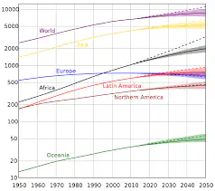
According to the graph, which is the continent that has grown the most?
Oceania
Asia
Latin America
Europe
A map that displays geographical boundaries and features related to political divisions, like national borders, state or provincial boundaries, county lines, city limits, and other administrative regions
Physical
Political
Thematic
Population
A map which is a representation of the natural features of a place, such as rivers, mountains, and deserts.
Thematic
Physical
Population
Political
A map that shows the spatial distribution of a specific topic or theme within a geographic area.
Population
Thematic
Physical
Political
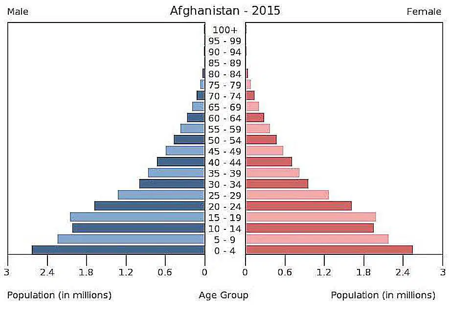
According to the population pyramid, which age group is the largest?
unborn
young
middle aged
old
Latitude causes a climate zone to be the way it is because of the distance it has from
the Equator
The Tropic of Cancer
the Prime Meridian
The Tropic of Capricorn
Commercial agriculture is when (select two answers)
Farmers grow food for themselves
Machines are used to farm
Farmers grow food to sell
Farmers use manual labor
Areas with mountains tend to be
average populated
not very populated
very populated
extremely populated
Traditional dance and textiles & carpet weaving are ___________.
cultural characteristics
political characteristics
religious characteristics
geographical characteristics
Some Caucasus region countries are (select two)
Armenia
Libya
Morocco
Georgia
What is GDP?
the total monetary or market value of all the finished goods and services produced within a country's borders in a specific time period
the total monetary or market value of the oil produced within a country's borders in a specific time period
an index which is used to measure the collective happiness and well-being of a population
none of the above
What does GDP represent?
Gross Domestic Product
Good News Program
Great Nations Patriots
Gross National Product
The countries that are tropical and subtropical are that climate because of....The season would change if the __________ of the earth changed.
sun
moon
tilt
people
Poor countries tend to rely on which industry?
Primary
Secondary
Tertiary
None of the above
What has isolated people in Central Asia?
Rivers
Oceans
Mountains
Grassland

