wayground logo

Free Printable Worksheets

Font size

S
M
L
XL
Worksheets

Geo/Hydro Review

Total questions: 46

Worksheet time: 1hrs 16mins

Name
Class
Date
1.

What is the geosphere?

a)

all of the water

b)

all of the gases

c)

all of the organisms

d)

all of the soil and rocks

2.

The outermost layer of Earth is called the

a)

crust

b)

outer mantle

c)

inner mantle

d)

core

3.

Magma is located in the

a)

crust

b)

mantle

c)

outer core

d)

inner core

4.

As you move in from the crust to the inner core, the temperature gets

a)

hotter

b)

colder

c)

stays the same

5.
Which is the correct order of layers of Earth from center to surface?
a)
outer core, inner core, mantle, crust
b)
inner core, outer core, mantle, crust
c)
crust, inner core, outer core, mantle
d)
crust, mantle, outer core, inner core
6.

The movement of the plates can cause (choose more than one)

a)

mountains

b)

tornadoes

c)

typhoons

d)

earthquakes

7.

The crust of Earth is broken into

a)

cups.

b)

plates.

c)

islands.

d)

volcanoes.

8.

areas where tectonic plates converge, diverge or slide past each other creating earthquakes and volcanic activity

a)

outer core

b)

plate boundaries

c)

inner core

d)

crust

9.

The process that creates new sea floor as plates move away from each other at the mid-ocean ridges

a)

sea floor spreading

b)

plate boundaries

c)

faults

d)

crust

10.

This rock is often found near water.

a)

Sedimentary

b)

Igneous

c)

Metamorphic

11.

You would most likely find this rock near a volcano.

a)

Sedimentary

b)

Igneous

c)

Metamorphic

12.

What kind of rock is "Granite"?

a)

Sedimentary

b)

Igneous

c)

Metamorphic

13.

What kind of rock is "Marble"?

a)

Sedimentary

b)

Igneous

c)

Metamorphic

14.

What kind of rock is "Sandstone"?

a)

Sedimentary

b)

Igneous

c)

Metamorphic

15.

What kind of rock is "Basalt"?

a)

Sedimentary

b)

Igneous

c)

Metamorphic

16.

This rock is usually made up of pieces of rock called sediments that have been pressed and cemented together.

a)

Sedimentary

b)

Igneous

c)

Metamorphic

17.
What are the 3 major types of rocks?
a)
Igneous, Metamorphic, Sedimentary
b)
Metamorphic, Igneous, Cementation
c)
Brown, Red, Gray
d)
Streak, Hardness, Breakage
18.
When sediments are pressed together tightly, this is called ____________.
a)
Compaction
b)
Cementation
c)
Weathering
d)
Erosion
19.
The process when rocks break into smaller pieces due to exposure to natural elements is called
a)
erosion
b)
weathering
c)
sediments
20.

The process by which metamorphic rock changes to igneous rock begins with

a)

melting

b)

erosion

c)

deposition

d)

crystallization

21.

Rocks that form from colling magma inside Earth?

a)

Igneous intrusive

b)

Igneous extrusive

c)

Metamorphic foliated

d)

Metamorphic nonfoliated

22.

Waves dropping sand on the beach is an example of what?

a)

Weathering

b)

Erosion

c)

Deposition

d)

Compaction

23.
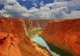
What land form is this?
a)
plain
b)
valley
c)
mountain
d)
canyon
24.
What land form is this?
a)
valley
b)
canyon
c)
mountain
d)
plain
25.
The type of formation shown is at the southern end of the Mississippi river. What is it called?
a)
coastal erosion
b)
a delta
c)
a loess
d)
sand dunes
26.
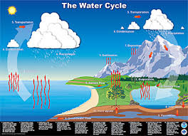
When water goes from being a liquid to a gas (water vapor), that process is called
a)
Condensation
b)
Evaporation
c)
Precipitation
d)
Transpiration
27.
Why is MOST of the freshwater on Earth not available for our use?
a)
All freshwater on Earth is easily accessible for use.
b)
It is frozen in the icecaps and glaciers.
c)
It is surface water.
d)
It is underground.
28.

All the water contained on Earth is called __________.

a)

the hydrosphere

b)

groundwater

c)

surface water

d)

the atmosphere

29.
How does the amount of water circulating in the water cycle change?
a)
The amount of water remains constant
b)
The amount of water increases each time it rains
c)
he amount of water decreases and then increases each day
d)
The amount of water decreases every time evaporation occurs
30.

When the clouds get too heavy and water falls back to earth

a)

Runoff

b)

Condensation

c)

Precipitation

d)

Transpiration

31.

Water running off the land surface.

a)

Runoff

b)

Precipitation

c)

Evaporation

d)

Sublimation

32.

There is only _________ percent of freshwater on earth.

a)

2

b)

3

c)

4

d)

5

33.

About _________ percent of all the water on Earth is in the form of salt water.

a)

90

b)

97

c)

95

d)

98

34.
What is it called when plants give off water vapor as a waste product?
a)
condensation
b)
evaporation
c)
sublimation
d)
transpiration
35.
During which stage do clouds form?
a)
condensation
b)
evaporation
c)
precipitation
36.

This provides the power to keep the water cycle running.

a)

The Sun

b)

The Earth

c)

The wind

d)

living things

37.

The weather of an area is affected by the air mass that is passing over it.

a)

True

b)

False

38.

Air pressure is measured using a(n) ________.

a)

hygrometer

b)

anemometer

c)

barometer

d)

thermometer

39.

____ is how hot or cold something is.

a)

temperature

b)

humidity

c)

altitude

d)

wind speed

40.
What type of weather is usually found in low pressure areas?
a)
hot and dry
b)
wet and stormy
c)
cold and snowy
d)
sunny and humid
41.
Which type of weather most likely occurs in a high pressure area?
a)
clear
b)
foggy
c)
rainy
d)
snowy
42.
A front is
a)
where warm air is cooling at earth's surface
b)
a boundary where hot and cold air are separating
c)
a boundary where two different air masses meet
d)
where cold air is rising and forming rain clouds
43.
A cold front usually brings what kind of weather?
a)
snow  
b)
sunny and fair
c)
heavy rain and/or thunderstorms 
d)
 cool and dry 
44.
Which weather tool measures wind?
a)
anemometer
b)
therometer
c)
wind vane
d)
barometer
45.
What does this symbol on a weather map indicate? 
a)
High pressure system
b)
Low pressure system
c)
Cold front
d)
Warm front
46.
What does this symbol indicate on a weather map? 
a)
High pressure system
b)
Low pressure system
c)
Cold front
d)
Warm front