
Font size
 Worksheets
Lithuanian Geography
Total questions: 20
Worksheet time: 11mins
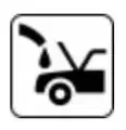
What does this conventional map symbol mean?
Gas Station
Automobile Repair Center
Traffic Light
Oil Station
What is the capital of Lithuania?
(a)
Which of the following is not a major city of Lithuania?
Sigulda
Klaipeda
Alytus
Kaunas
Which of the following countries borders Lithuania?
Belarus
Estonia
Russia
Ukraine
What body of water is the Lithuanian coastline on?
Black Sea
Kara Sea
The Baltic Sea
The Pacific Ocean
What climate zone is Lithuania in?
dry climate zone
continental climate zone
temperate climate zone
polar climate zone
Which of the following is not a major river of Lithuania?
Venta River
Neris River
Nemunas River
Pedja River
What is the longest river in Lithuania?
Šventoji River
Nemunas River
Neris River
Muša River
Which Lithuanian river goes through the capital city?
Nemunas River
The Mississippi River
Neris River
Nile River
What are the historical/cultural regions of Lithuania?
Aukštaitija, Mažoji Lietuva, Vilnius, Latvia and Sūduva
Žemaitija, Aukštaitija, Mažoji Lietuva, Suvalkija/Sūduva, and Dzūkija.
Žemaitija, Aukštaitija, Mažoji Lietuva, and Dzūkija.
Vilnius, Klaipėda, Kaunas, Marijampolė, and Žematija
Which country does not border Lithuania?
Poland
Estonia
Latvia
Belarus
How tall is the highest point in Lithuania (Aukštojas Hill)?
24,000 feet
957 feet
10,540 feet
536 feet
What is the coldest temperature ever recorded in Lithuania?
-45.2 F
-25.5 F
-13.8 F
3 F
What is the hottest temperature ever recorded in Lithuania?
129.5 °F
99.5 °F
109.5 °F
89.5 °F

What does this conventional map symbol mean?
Powelines
Highway
Foot Path
Bike Trail
What is the conventional map sign for for a cemetary?





What does this conventional map symbol mean?
Roundabout
Railroad Crossing
Bus Station
Stoplight Ahead
How many square miles is the country of Lithuania?
25,212 sq mi
50,360 sq mi
15,514 sq mi
125,700 sq mi
What US State is the closest in size to Lithuania?
Alaska
Michigan
West Virginia
New York
What is the largest ethnogrpahic region of Lithuania?
Vilnius
Aukštaitija
Žemaitija
Dzūkija

