
Font size
 Worksheets
Unit 9 South Asia Review
Total questions: 23
Worksheet time: 12mins
The Ganges has been considered a sacred river in Hinduism for thousands of years. Millions of Hindus perform religious rituals, such as purification rites and the disposal of the deceased, in the river. How have these long-practiced rituals affected the river today?
The level of the river has dropped due to considerable use.
The river has become one of the most polluted in the world.
The river is one of the cleanest rivers in the world since it is considered sacred.
The course of the river has been altered to feed into temples.
Which geographic pattern emerged in South Asia because of the events detailed in the excerpt above?
New political borders were created to divide ethnic groups in the region.
Strict laws reinforcing religious differences were passed in Pakistan and India.
Democracies emerged in both Pakistan and India based on British colonial traditions.
Nations in the region formed economic bonds that have promoted growth in the area.
Which factors most account for the creation of a tropical climate throughout much of the Indian subcontinent?
Location in the mid latitudes
Highland conditions of the Himalayas
Size in area of the subcontinent landmass
Proximity to the Indian Ocean and the equator

Based on the information in the graphs, which issue is India likely to face in 2050?
Paying health care and expenses for growing numbers of elderly
Providing education for a growing demographic of young children
Finding well-paying jobs for young people entering the workforce
Avoiding political instability resulting from large population growth

Which prediction about India’s population is supported by the information on the graph?
Life expectancy in India will increase in the twenty-first century.
After the twenty-first century India will experience a zero-growth rate.
India will surpass the population growth of other nations in the twenty-first century.
Elderly persons will outnumber younger generations in India during the twenty-first century.
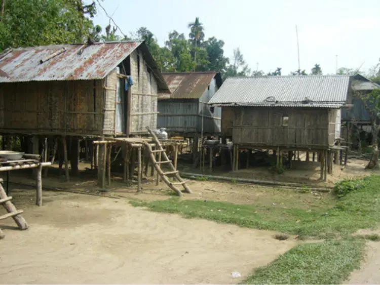
Building in the style shown in the picture above is important in Bangladesh because —
providing space for large families is important
adapting to the extensive flooding is necessary
having storage for surplus crops is important
increasing tourism has opened new rental markets
What is one way India’s rapid population growth has affected the environment of the region?
Seismic activity has rapidly increased.
Air and water pollution has worsened.
Rainfall levels from monsoons have lessened.
Buildings in the region have been redesigned.
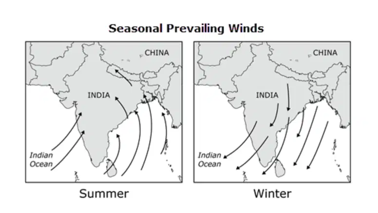
What impact would the physical process shown in the map most likely have?
Increased rainfall in the summer and dry conditions in the winter
Frequent hurricanes causing destruction year-round
Erosion leading to land degradation in all seasons
Varied precipitation patterns with heavy rains in the summer and snow in the winter
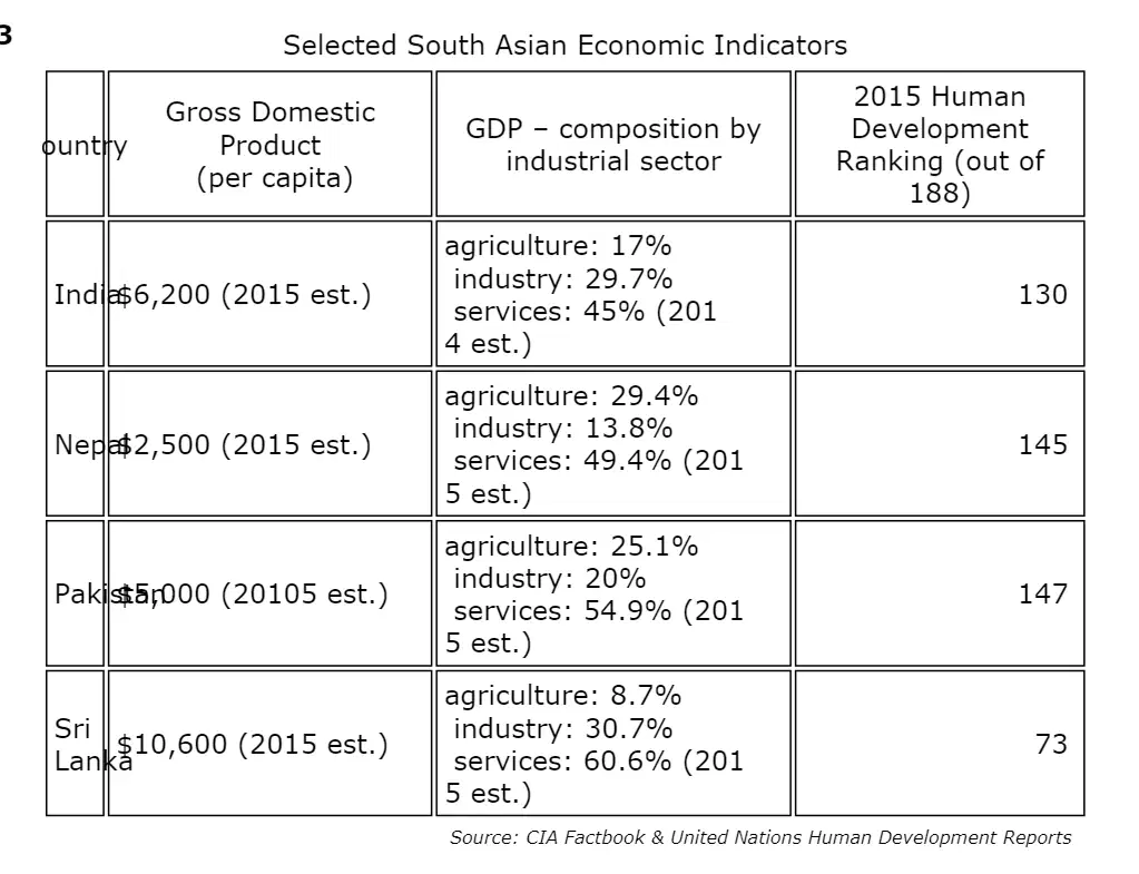
Which economic pattern is illustrated by the data in the table?
Employment in South Asia that contributes most to GDP is in tertiary industries.
Secondary economic activities account for most of the GDP of South Asian nations.
Less developed countries in South Asia have economies with large tertiary industries.
Highly developed countries in South Asia have highly developed agricultural sectors.
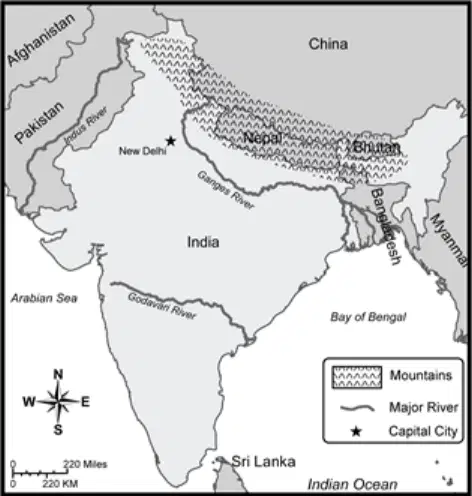
How did geography contribute to the creation of India's northern border?
North of the border is too cold to easily support life.
The Ganges River is a natural boundary between India and China.
Nepal contains few resources of interest to India or China.
The mountains form a natural boundary between India and other countries.
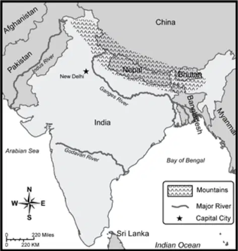
Based on the map, Nepal and Bhutan differ from other South Asian countries because both are —
on the border with India.
considered island nations.
geographically landlocked.
lacking freshwater sources.
After British leaders ended colonial rule of India, Indian leaders consolidated their authority over the subcontinent by —
ratifying a constitution
expelling Sikhs from the region
making English the official language
opening diplomatic relations with Russia
After gaining independence in 1947, ethnic and religious differences continued to trouble Pakistan. Early efforts to establish stability in the region eventually resulted in which group dominating political control of Pakistan?
Muslim ayatollahs
Military officers
British monarchs
United Nations peacekeepers
While both North America and South Asia experienced British colonization, cultural patterns in South Asia were more strongly influenced by —
rapid population growth
European social customs
ancient religious traditions
British literary and artistic styles
Why is the region of Kashmir a source of conflict among nations of South Asia?
It is the only region dominated by Sikhs.
It is an extremely poor region that often faces natural disasters.
Its people are predominantly Islamic, though controlled by India.
Its people are predominantly Hindu, surrounded by an Islamic nation.
Which cultural tradition still characterizes Indian society today, despite being outlawed in 1947?
Reincarnation
Caste distinctions
Arranged marriages
Praying five times a day
Which of the following are associated with Buddhism?
Reincarnation
Four Noble Truths
Eightfold Path
Siddhartha Gautama
Five Pillars
Which historic conflict was a primary reason for the political division of Pakistan and India?
Differences between Hindus and Sikhs
Disputes between Muslims and Hindus
Tensions between the British and Indian leaders
Cold War tensions between the United States and Russia
Which physical process is most responsible for the geographic formation in the northern Indian subcontinent?
Deposition
Weathering
Tectonic forces
Hydrologic cycle

Based on the information in the map, India's largest cities are located in
southwest and northeast India
central and northeast India
northwest and southeast India
east and northwest India
India Set for Bumper Winter Crops in Wake of Monsoon Rains - Reuters News Service, October 23, 2013
Based on the news headline above, what is one way that monsoons affect India?
Strong monsoon winds rapidly spread seeds across farmer's fields and pastures.
Rains that are produced by monsoons promote sustainable economic development.
Monsoons bring rains that cause widespread destruction to property from flooding.
Tsunamis that accompany the monsoons are responsible for many deaths each year.
Which statemen accurately describes monsoons in India?
Monsoons bring heavy rainfall in all seasons in India.
Monsoons only affect the coastal regions of the Indian subcontinent.
Winter monsoons bring heavy rainfall, while summer monsoons are fairly dry.
Summer monsoons bring heavy rainfall, while winter monsoons bring dry weather.
The Times of India
January 2014
Six Indian cities among top outsourcing hubs
Which technological changes contributed most to the development reported in this headline?
Creation of faster modes of transportation
Increased online educational opportunities
Expanded communication with the Internet
Invention of computer language translators

