NEW
Font size
 Worksheets
OST Earth Sci Review
Total questions: 40
Worksheet time: 27mins

What information do the layers in the ice cores provide?
Provide information related to Trilobites.
Provides a record past atmospheric conditions.
Provides information related to the extinction of the species.
Provides information related to the physical characteristics of organisms.
All of the features are created by Erosion of WATER other than...
Meandering Rivers
Oxbow Lakes
Canyons
Beaches

Which characteristics of a fossil would make it useful as an index fossil in determining the age of widely separated rock layers?
a wide time range and a narrow geographic range
a wide time range and a wide geographic range
a narrow time range and a wide geographic range
a narrow time range and a narrow geographic range

Index fossils help scientists estimate the age of a rock because index fossil species only existed for a relatively short time. What happened to the species that are now used as index fossils?
They became extinct.
They changed their diets
They hid in marine sediments.
They migrated to new environments.

The diagram below represents three bedrock outcrops. The layers have not been overturned. Letters A through E identify different rock layers. Fossils found in the rock layers are shown.
Which fossil could be classified as an index fossil?


The cross sections below represents three widely separated outcrops of exposed bedrock. Letters A, B, C, and D represent fossils found in the rock layers.
Which fossil appears to have been the best characteristics of an index fossil?
A
B
C
D


Thicker tree rings indicate poor growing conditions for plants and trees.
True
False

Which year was the rainiest?
Year 1
Year 2
Year 8
Year 16
When was the 3 year drought observed?
Year 1-3
Year 2-4
Year 9-11
Year 14-16

What do fossils of tropical plants found in Antarctica tell you about its location?
Antarctica is in the same location as it was in the past
Tropical fossils have yet to be found in Anartica.
Antarctica has shifted from the Northern part of the globe to the Eastern part of the globe
Antarctica was likely closer to the equator at one point, but the continent has moved throughout Earth’s history
What information do the layers in the ice cores provide?
Provide information related to Trilobites.
Provides a record past atmospheric conditions.
Provides information related to the extinction of the species.
Provides information related to the physical characteristics of organisms.
All of the features are created by Erosion of WATER other than...
Meandering Rivers
Oxbow Lakes
Canyons
Beaches

Plates move towards one another at ______________ boundaries.
divergent
convergent
transform
detergent
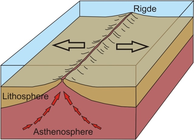


Plate movement is caused by ______________.
the rotation of the Earth
ocean tides
convection currents in the mantle
the moon's gravity


Refer to the image!!
Which description matches #3?
Heating of cooler material
Movement of less-dense material
Movement of denser material
Cooling of warmer material
Which of the following is NOT a piece of evidence that supports the movement of the Hawaiian islands?
Distance from the hot spot is changing over time.
Direction of the plate movement has been determined.
Hawaii is sitting near a plate boundary.
Latitude and longitude of the island and the hot spot have been determined.

According to the image, which Hawaiian island is the oldest?
Hawaii (main land)
Kauai
Molokai
Maui

High discharge streams move in a straight line, low discharge streams meander. As streams slow, they deposit sediment.
Which mass of sediment would be the last to deposit in a river system?
24 g
186 g
12 g
2000 g

Many land features are formed as glaciers drift or retreat downhill due to gravity. Which land feature is formed due to erosion by ice?
U Shaped Valley
Sand Dune
Meanduring River
Mudflow

This image captures a 'creep' out in nature. Which option best describes the reason why a 'creep' forms?
Rapid mass movement
Gradual mass movement
Erosion by water
plate tectonic movment

Landslides and mudslides are caused by...
Gravity
Earth's Rotation
Deposition
Wind

A topographic map is a map that shows the surface features, or topography, of an area using contour lines.
What is the contour interval in this map?
10 m
20 m
40 m
100 m

This is Rock Mountain.
At which face of the mountain can you find the highest gradient?
North
South
East
West
A topographic map is a map that shows the surface features, or topography, of an area using contour lines.
What is the HIGHEST elevation noted in this map?
220m
100ft
240m
280m

This is a RIVER DELTA. At which point was this landform created?
By Erosion of sediment
By Deposition of sediment
By Chemical Weathering of sediment

This is a landform developed from DEPOSITION of Water. What is it called?
Alluvial Fan
Delta
Canyon
Meandering River

Which landforms are formed due to EROSION by WATER?
Volcanoes
Alluvial Fans and Deltas
Canyons and Valleys
Mountain Chains