
 Worksheets
Unit 10 & 11 Review
Total questions: 29
Worksheet time: 44mins

Based on the map, how does the location of China today reflect the history of the region?
Modern China is located at a crossroad of invasion routes.
Much of modern China contains the cultural hearth of its ancient past.
The location of Chinese culture has steadily moved eastward to the coastline.
Chinese culture has become more concentrated in a smaller region over time.

What does this image reveal about life in Japanese society?
Most people in Japan must commute to work.
Population density affects daily activities in Japan.
Helping strangers is a cultural expectation in Japan.
Spending on transportation infrastructure is a priority in Japan.

Based on the Human Development Index from 1980 to 2011, which country shows a consistent upward trend in development?
China
Japan
Korea (Republic of)
All of the above
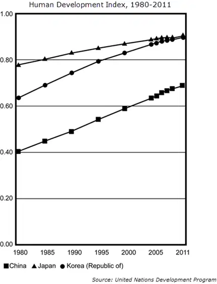
What conclusion about economic development in China, Japan, and Korea is reflected by the data in the graph?
Korea’s economic development has lagged recently.
Korea and Japan are at a similar level of development.
China’s economic development exceeds that of Korea.
Japan is far more developed than either China or Korea.
Which geographic feature of western China most accounts for its sparse population compared to the eastern part?
Mountainous terrain
Threat of earthquake
Lack of access to water
Political conflict with Tibet

Which conclusion most accurately compares the populations of China and the world based on the graph from 1960 to 2010?
More than half of the world's population is in China.
China's population is growing at a faster rate than the world.
The world's population is growing at a faster rate than China.
The populations of both China and the world are growing at a similar rate.

According to the excerpt, why has the management of epidemics in China become a greater challenge?
The health care capacity of China is declining.
The population of China is growing more susceptible to disease.
Globalization is leading China to be more connected with nations around the world.
New diseases are emerging more rapidly than Chinese doctors can diagnose and treat.
One way that both China and Japan have modified the environment has been by building infrastructure needed to:
bring water to remote villages
manage pollution created by industry
repair damage done by volcanic activity
supply energy to large, growing populations
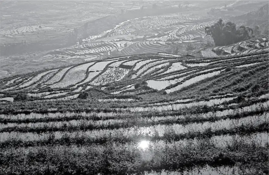
The agricultural practices seen in the photograph are an example of —
globalization
cultural convergence
technological diffusion
modification of the environment

Where would Japan likely fall on the economic spectrum?
Communism
Socialism
Free Enterprise
None of the above

Where does the independent city-state of Singapore likely fall on the economic spectrum?
Communism
Socialism
Free Enterprise
None of the above
Why has Singapore served as an important location for globalization in the world?
It is a center of agriculture production, exporting rice and wheat to the region
It is an international port city, connecting trade across the Indian and Pacific oceans
It has the world's busiest airport, providing connections to Australia and the Asian mainland
It serves as a major center for education, with many people traveling from across Asia to attend its schools and universities
What is one way the governments of China and the United States operate differently?
In China the electorate only has one party to choose from and in the United States there are multiple political parties
In China elections are only conducted on the provincial level and in the United States elections are held on the national level
In China the executive leader is elected by a legislative body and in the United States the executive leader is chosen by popular vote
In China legislative representatives are chosen from groups of local leaders and in the United States legislative representatives generally have served as state governors
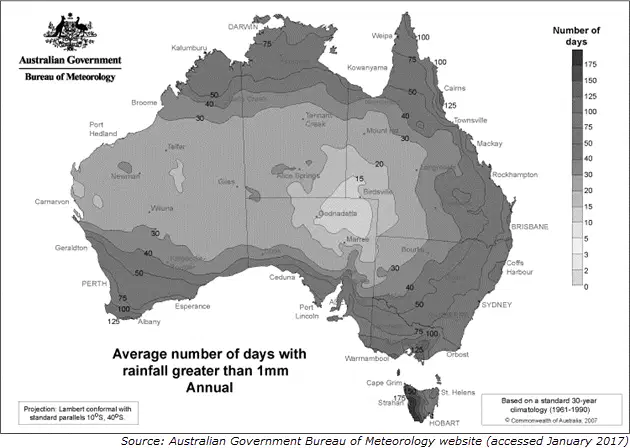
Which condition most affects the average rainfall in Birdsville, Australia?
Its corresponding latitude
Its position on the continent
Its location in the Southern Hemisphere
Its close proximity to a political border
Micronesia and Polynesia are dominated by low islands that were once volcanoes. These small, low islands form in irregular rings known as —
a fjord
an atoll
an estuary
a barrier reef
Melanesia is made up of many high islands which were formed by —
Earthquakes
Wind erosion
Glacial erosion
Volcanic activity
Which physical process was responsible for the formation of continental islands, such as Australia, Zealandia, and New Guinea?
Water erosion
Glacial soil building
Growth of coral reefs
Tectonic plate movement

Which physical process is most likely responsible for the landform shown in the image?
Erosion
Monsoons
Volcanic activity
Tectonic divergence
Papua New Guinea’s proximity to the equator is responsible for creating a biome in the region which is characterized by —
desert
steppes
deciduous forests
tropical rainforests

The rainfall pattern illustrated on the map is responsible for most of Australia being covered by what type of biome?
Desert
Forest
Savanna
Tundra
How have the climate regions in Australia influenced settlement patterns?
Densely populated areas located along major rivers
A concentration of urban centers along the eastern coast
An even split of the population living in villages and in cities
A majority of people living in villages scattered across the continent

Which factor most contributed to the change in the settlement patterns of the original inhabitants of Australia shown on the maps?
Better irrigation techniques led many original inhabitants to move to land that previously had not been farmed.
Population increases among European colonists pushed many original settlements from the coast to the interior.
Climate changes led many original inhabitants to move away from increasingly violent storms along the coastline.
Changing employment opportunities forced many original inhabitants to work for large farms and ranches in the interior.
Which modification of the physical environment in both Brazil and Papua New Guinea has concerned environmental advocates due to its impact on similar biomes in these regions?
Deforestation
Desertification
Mining
Overgrazing
What economic activity did early European settlers in New Zealand introduce to take advantage of the mild climate?
Wind farming
Sheep ranching
Sugar cultivation
Solar power production

Which conclusion about the Maori is best supported by the images provided in the learning material?
Some members of the Maori have maintained their traditional ways.
Original Maori traditions have been abandoned by the Maori of today.
Many Maori today have blended tribal traditions with European culture.
Members of the Maori have modernized and adapted to colonial traditions.
How do large segments of the population of Papua New Guinea and the Pacific Islands meet their basic economic needs?
Providing services to tourists
Practicing subsistence farming
Producing small commercial crops
Creating commercial fishing companies
How does the summer monsoon season benefit the region of Southeast Asia?
It provides plentiful rains for rice fields.
It calms ocean waves to provide for good fishing conditions.
It prevents the approach of typhoons from the Pacific Ocean.
It has strong winds that clear out cloudy skies for months of sunshine.
The eastern portion of China is densely populated, while the west is very sparsely populated. Which of the following geographic feature of western China most accounts for this settlement pattern?
Mountainous terrain
Threat of earthquake
Lack of access to water
Political conflict with Tibet
The distribution of climate regions in Australia has created settlement patterns characterized by -
densely populated areas located along major rivers
a concentration of urban centers along the eastern coast
an even split of the population living in villages and in cities
a majority of people living in villages scattered across the continent

