
 Worksheets
Geography Final
Total questions: 73
Worksheet time: 52mins
Exact location for a place on the earth described by global coordinates
Basin
continent
cultural feature
absolute location

One of the seven large land masses on the earth
Basin
continent
cultural feature
absolute location
Characteristic that humans have created in a place, such as language, religion, housing, and settlements patterns
Basin
continent
cultural feature
absolute location

Area of land drained by a given river and it branches; area of land surrounded by lands of higher elevation
Basin
continent
cultural feature
absolute location

Distance north or south of the Equator measured by degrees
Longitude
Latitude
Map
Isthmus

Distance east or west of the Prime Meridian, measured in degrees
Longitude
Latitude
Map
Isthmus

Large body of water completely or partly surrounded on the three sides by land.
sea
mouth of river
mountain range
tributary
Small river or stream that flows into a larger river or stream; a branch of a river
Peninsula
mouth of river
mountain range
tributary

Area of low land between hills or mountains
Prime meridian
strait
plateau
valley
Area of flat or rolling land at a high elevation and often covered with grasses.
Prime meridian
strait
plateau
valley
Body of water between a coastline and one or more islands off the coast.
sea coast
strait
sound
valley

How do polar climates differ from temperate climates?
Polar climates are warmer and wetter.
Polar climates have more biodiversity.
Polar climates are colder and have less precipitation.
There is no significant difference between the two.
Temperatures in the TROPICAL ZONES are...
cold all year
always warm
warm in summer and cold in winter
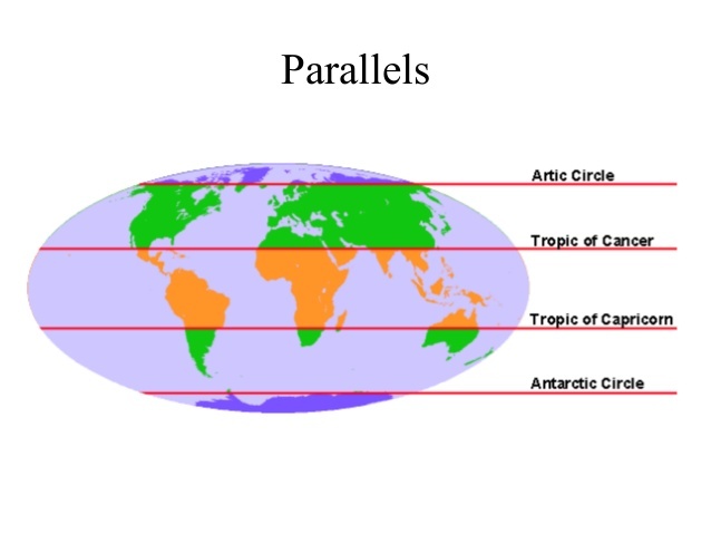
Which climate region is in green/in between the tropics and the poles
Hot
Polar
Temperate
None of the above
Which climate is hot and wet all year?
Temperate
Tropical
Arid

🏔️ Can you guess where the majestic Andes Mountains call home? 🌎
Africa
South America
North America
Asia

Flat, open grasslands
mesa
plains
estuary
tundra

Examine the two maps below of Australia to accurately answer the question that follows.
Australia's interior is the least densely populated part of the country, which is mostly due to...
climate
altitude
conflict
distance
What was a consequence of the one-child policy on China's workforce?
A surplus of young workers
Increased diversity in the workforce
A shortage of young workers
A more balanced gender distribution in the workforce
7.1 Where would you be mostly likely to find a large cornfield?
Urban Area
Exurban Area
Suburban Area
Rural Area
What 2 countries have the largest population?

Totalitarianism, like in North Korea allows
free use of personal technology like phones, internet, etc.
freedom of speech
the people to elect all their government officials
very few human rights


A narrow passage of water connecting two large bodies of water.
Atoll
Strait
Tsunami
Plateau

Rainy seasons in southern Asia that last for an extended period of time.
Tsunami
Monsoon
Atoll
Strait

Select all the physical landforms below.
Mount Everest
The Great Wall of China
Peninsula
Plateau

A rip current is a specific type of water current that can occur near beaches where waves break. A rip is a strong, localized, and narrow current of water that moves directly away from the shore to open water. According to the image what direction should you swim to escape a rip current?
Fight the current and try to swim directly back to shore
Swim left or right, parallel to the shore
Swim out to sea
infrastructure
a factor that induces people to move to a new location
A factor that induces people to move out of their present location
systems that facilitate communication and transportation in a community
the process of increasing connectivity between the world's societies.
What is the term for the natural or human destruction of forests?
biodiversity
deforestation
urbanization
migration
What is the term for the process by which culture is spread?
cultural divergence
urbanization
migration
cultural diffusion
the gradual transformation of habitable land into desert; is usually caused by climate change or by destructive use of the land
using violence or the threat of violence to create fear in an effort to bring about social or political changes
A form of government in which the people rule either directly or indirectly through representatives.
monarchy
democracy
diffusion
republic
A form of government that has a single person as its ruler, usually a king or queen.
monarchy
culture
democracy
republic
A form of government in which a state is ruled by representatives of the citizens.
points of view
republic
democracy
monarchy
A physical material that humans need and value such as land, air, and water.
innovations
resources
culture
diffusion
Trade and technology have made the world into a more connected and interdependent place.
resources
diffusion
culture
globalization
Society based on equitable distribution of wealth, land, and public ownership of production
Communism
Democracy
Autocracy
monarchy
The tallest mountain in the world is...
Mount Kilimanjaro
Denali
Mount Everest
Matterhorn
The largest continent...
Africa
Asia
North America
Antarctica

Which continent is shaded YELLOW and labeled with the letter F?
South America
Europe
Asia

Which continent is shaded RED and labeled with the letter A?
Europe
North America

Which continent is shaded PURPLE and labeled with the letter B?
Asia
North America
South America

Which continent is shaded GREEN and labeled with the letter D?
South Asia
North America
Asia
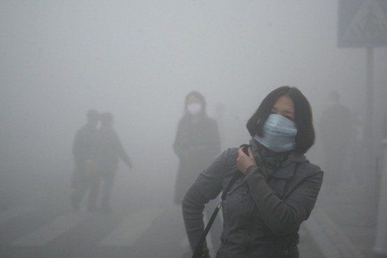
Which human action can cause pollution?
Walking
Biking
Mining
Recycling

The CAUSES of desertification are:
drought
overgrazing
human environment interaction such as deforestation
all of the above

Ancient Rome looked at Greece's direct democracy and said, "Our territory is too big for that." Instead, they had citizens vote for people to run the government FOR them. This is called...
representative democracy
autocracy
anarchy
theocracy

1903- The 48 mile international waterway allows ships to pass between the Atlantic and Pacific Ocean, saving about 8,000 miles. ¨Expansion of World trade. What type of landform is Panama(circled in blue)
Island
Peninsula
Plateau
Isthmus


Which bar graph is the same as the data in the circle graph if 20 people were surveyed?


Which month had the biggest difference between the high and low temperatures?
January
April
October
November

The table shows the air temperature and dewpoint at each of four locations, A, B, C, and D. Based on these measurements, which location has the greatest chance of precipitation?
A
B
C
D

According to the map, where were the British Forces leaving from?
Boston
Concord
Lexington
Cambridge

On the map, what area of the United States has the highest elevation?
Western
Eastern
Northern
Southern
The Ring of Fire is an area in the Pacific Ocean where there are many volcanoes and earthquakes are frequent. What country is in the Ring of Fire?
China
North Korea
South Korea
Japan


What country is marked by a red star?
South Korea
North Korea
Japan
China

What country is this?
North Korea
Taiwan
Japan
Mongolia

What country is this?
South Korea
North Korea
Japan
Mongolia

What is this physical feature is found in Japan?
Mount Everest
Mount McKinley
Mount Fuji
Mount Kilimanjaro


What would have caused the bulleted list?
Tornado
Dust storm
Tsunami
Which of the following are the MOST common religions in East and Southeast Asia? Select THREE correct answers.
Islam
Confucianism
Buddhism
Judaism
Taoism

