
 Worksheets
Geodesy 2 - Quiz IV
Total questions: 25
Worksheet time: 8mins
........................ is a discipline within engineering that focuses on designing and analyzing systems where direct line-of-sight communication or observation is crucial.
Geodetic engineering
Communication surveying
LOS engineering
None of the above
Triangulation stations should be chosen on high ground so that all relevant stations are ................
accessible
inaccessible
intervisible
None of the above
If the distance between stations is large, the intervisibility is ascertained by knowing the .................. between the stations.
vertical angle
horizontal distance
azimuth
None of the above
h=D2/2R(1−2m), in this equation, m above ocean equals ........
0.08
1.07
0.07
1.08
In ............................... the two points with known coordinates are occupied and sightings are taken to the unknown point.
intersection
resection
three-point problem
satellite station
In this system the coordinates U, V, W are expressed as functions of the observed azimuth A, zenith distances Z & spatial distance S
geodetic system
cartesian system
Horizon system
None of the above
An irregular surface reflecting the Earth's gravity variations
Geoid
Elliposoid
spheroid
None of the above
What is a major factor influencing the difference between a datum and a geoid?
The distribution of landmasses
The Earth's rotation speed
The presence of the atmosphere
None of the above
A datum is built on top of the .................... and can incorporate local variations in ................
coordinate system - elevation
geoid - undulation
sphereoid - elevation
None of the above
What is the relationship between a datum and coordinate systems?
They are the same
They are unrelated.
A datum is a type of coordinate system.
A datum defines the origin, orientation, and scale of a coordinate system.
Three-dimensional (3D) conformal transformations are commonly used in surveying because of ....................
Weather prediction
Shape preservation
preserving areas
None of the above
................................. are 3D transformations used to convert coordinates related to one geodetic datum to another.
Resection
Datum transformation
Intersection
Triangulation
................................ is the galaxy that includes the Solar System
Milky way
Jupiter
Earth
None of the above
Orthometric heights differ from each other at the same level surface because:
They are measured along a straight line.
The level surfaces are not perfectly flat.
They consider the Earth's rotation.
They are measured along the curved plumb line.
The normal height of a point P is the geometric distance between P and:
Geoid
The reference ellipsoid at the same longitude
A point directly below P on the reference ellipsoid
The point with the same potential value on the geoid
Geopotential numbers are used to calculate all of the following EXCEPT:
Orthometric heights
Normal heights
Undulation
Dynamic heights
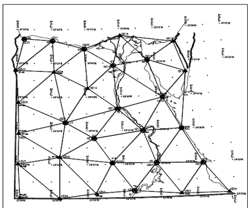
This figure shows the ......................... Egyptian geodetic network.
Traditional
HARN
Triangulation
None of the above
An ellipsoid that fits the geoid very well in a certain country does not necessarily fit in other country.
True
False
What is the preliminary assumption at the initial point of a traditional geodetic network?
Theta = 0
Geoid and ellipsoid are tangent to each other
deflection of the vertical equals zero
All of the above
The position of the datum initial point “i” (starting point of the network) to be in the geometrical center of the region of interest, and having a rigid terrain surrounded by areas of modest variations in gravity.
True
false
What is the primary purpose of a geodetic network?
To measure distances accurately
To establish a reference framework for spatial measurements
To predict weather patterns
None of the above
Which of the following is NOT a component of geodetic engineering?
Geoid modeling
GPS technology
Weather forecasting
Coordinate systems
What is the significance of orthometric heights in geodesy?
They represent the height above the geoid
They are used for weather prediction
They determine the rotation speed of the Earth
None of the above
Which type of transformation is commonly used in surveying due to its shape preservation properties?
Conformal transformations
Resection transformations
Intersection transformations
None of the above
The quantities 𝛷 , 𝛬 , and 𝐻 define the position of the observer with respect to .................
the spheroid & the mean rotational axis of the earth
the geoid & the mean rotational axis of the earth
the geoid & the ellipsoid normal
None of the above

