
 Worksheets
Map Skills, Timeline and Sources Quiz Practice
Total questions: 12
Worksheet time: 7mins
Name
Class
Date
1.
This symbol indicates a capital city on a map.
a)
Star
b)
Blue H
c)
Tent
d)
Knife and fork
2.
Fill in the blanks:
Lines of latitude run from ___________ to __________.
a)
west to east
b)
north to south
3.
Which of the following examples are PRIMARY sources?
a)
A biography about Abraham Lincoln
b)
The movie Titanic
c)
A reporter describing his time in Iraq
d)
Rosa Parks describing her role in the Montgomery Alabama bus boycotts
4.
Fill in the blanks:
Lines of longitude run from ___________ to __________.
a)
west to east
b)
north to south
5.
True or False: When looking at a map, the size of the dot next to a city gives you an idea of how large or small the city is.
a)
True
b)
False
6.
Fill in the Blank: The Prime Meridian is the 0 Degree line of _______.
a)
latitude
b)
longitude
7.
Earth is divided into 4 hemispheres. Which is NOT a hemisphere on Earth?
a)
northern
b)
southern
c)
western
d)
middle
8.
What is a secondary source?
a)
information that was created at the same time as an event or by a person directly involved in the event
b)
A source that gets its information from somewhere else or by a person not directly involved in the event.
9.
Which continent is the largest?
a)
Africa
b)
Asia
c)
North America
d)
Antarctica
10.
Which ocean is the newest?
a)
Pacific
b)
Atlantic
c)
Arctic
d)
Southern
11.
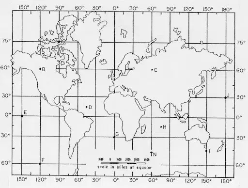
Which continent is located at 30 S, 60 W?
a)
North America
b)
Europe
c)
Asia
d)
South America
12.
Put these dates in order from oldest to youngest. Remember the middle line is "0".
a)
160 CE
b)
AD 300
c)
44 BCE
d)
1400 BC
1
2
3
4
1)
2)
3)
4)
100 %

