Wayground logo

Free Printable Worksheets

Font size

S
M
L
XL
Worksheets

Geography Review

Total questions: 40

Worksheet time: 40mins

Name
Class
Date
1.
Which continent is marked by the star?
a)
Asia
b)
Africa
c)
Australia
d)
Europe
2.
Which continent is marked by the star?
a)
Africa
b)
Europe
c)
Asia
d)
North America
3.
Which continent is marked by the star?
a)
North America
b)
South America
c)
Asia
d)
Antarctica
4.
Which continent is marked by the star?
a)
Asia
b)
Africa
c)
Europe
d)
South America
5.
Which continent is marked by the star?
a)
North America
b)
Asia
c)
Africa
d)
South America
6.
Which continent is marked by the star?
a)
Africa
b)
Antarctica
c)
Asia
d)
Australia
7.
Which continent is marked by the star?
a)
Antarctica
b)
Asia
c)
Australia
d)
North America
8.
Which ocean is marked by the star?
a)
Atlantic
b)
Arctic
c)
Southern
d)
Indian
9.
Which ocean is marked by the star?
a)
Indian
b)
Pacific
c)
Atlantic
d)
Southern
10.
Which ocean is marked by the star?
a)
Arctic
b)
Pacific
c)
Atlantic
d)
Indian
11.
Which ocean is marked by the star?
a)
Southern
b)
Indian
c)
Arctic
d)
Atlantic
12.
Which ocean is marked by the star?
a)
Pacific
b)
Indian
c)
Atlantic
d)
Arctic
13.

The ________ shows us the distance on a map in inches or centimeters.

a)

scale

b)

longitude

c)

latitude

d)

compass rose

14.

The equator is a line of:

a)

longitude

b)

latitude

15.
What is the name of the line at zero degrees longitude?
a)
Equator
b)
Prime Meridian
c)
North Pole
d)
South Pole
16.
What is the name of this line at 0 degrees latitude?
a)
Prime Meridian
b)
Equator
c)
North Pole
d)
South Pole
17.

A map that shows the natural features of the Earth's surface such as landforms, bodies of water and land elevation is called

a)

Political map

b)

Topographical map

c)

A world map

18.

A map that shows boundaries of nations, other political areas, capitals and cities is called…

a)

A physical map

b)

A political map

c)

A topographical map

19.
What are the imaginary lines that crisscross the globe which geographers use to find absolute location?
a)
Latitude and Longitude
b)
Meridians and Time Zones
c)
Rivers and Deltas
d)
Mountains and Deserts
20.
What part of a map is this?
a)
Compass Rose
b)
Scale
c)
Title
d)
Legend
21.
What part of a map is this?
a)
Scale
b)
Title
c)
Legend
d)
Compass Rose
22.
What part of a map is this?
a)
Title
b)
Legend
c)
Scale
d)
Compass Rose
23.

What type of map is this?

a)

Special Purpose Map

b)

Physical Map

c)

Political Map

d)

Sociological Map

24.

What type of map is this?

a)

Special Purpose Map

b)

Physical Map

c)

Political Map

d)

Imperial Map

25.

What type of map is this?

a)

Special Purpose Map

b)

Physical Map

c)

Political Map

d)

Mongolian Map

26.

Employees in the same company from the United States, Germany, and Japan participate in a virtual meeting by using Skype in their homes.

a)

Place

b)

Movement

c)

Location

27.

The latitude and longitude coordinates of New York City, the United States is 41° North, 74° West.

a)

Human/Env. Interaction

b)

Relative Location

c)

Absolute Location

28.

The Caribbean Islands have a tropical climate.

a)

Location

b)

Region

c)

Human/Env. Interaction

29.

Chicago is about 200 miles south of Green Bay on Interstate Highway 43.

a)

Place

b)

Relative Location

c)

Absolute Location

30.

38 degrees South Latitude, 83 degrees East Latitude is an example of

a)

Absolute location

b)

Relative location

31.

locates a place on earth by finding where is it using absolute and relative location

a)

movement

b)

relative location

c)

absolute location

d)

location

32.

describes how people, goods, and ideas move throughout the area

a)

movement

b)

transportation

c)

region

d)

location

33.
Latitude and longitude are measured in ________.
a)

cups

b)

gallons

c)

degrees

d)

Fahrenheit

34.
Lines of longitude are also called  ____________.
a)
Hemispheres
b)
Meridians
c)
parallels
d)
International Date Lines
35.

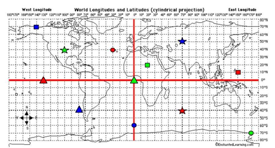
What are the coordinates for the RED star?

a)

40*S, 70*E

b)

40*N, 30*W

c)

0*, 130*W

d)

10*N, 150*E

36.

What are the coordinates for the RED Square?

a)

40*S, 70*E

b)

40*N, 30*W

c)

0*, 130*W

d)

10*N, 150*E

37.

What are the coordinates for the RED Triangle?

a)

40*S, 70*E

b)

40*N, 30*W

c)

0*, 130*W

d)

10*N, 150*E

38.

What are the coordinates for the RED Circle?

a)

40*S, 70*E

b)

40*N, 30*W

c)

0*, 130*W

d)

10*N, 150*E

39.

What are the coordinates for the BLUE Star?

a)

40*S, 80*W

b)

60*S, 0*

c)

70*N, 140*W

d)

50*N, 70*E

40.

What are the coordinates for the BLUE Circle?

a)

40*S, 80*W

b)

60*S, 0*

c)

70*N, 140*W

d)

50*N, 70*E