
Font size
 Worksheets
Map Reading Review - Direction, Scales and Contours
Total questions: 38
Worksheet time: 58mins
How many map scales are there?
3
6
9
12
Map scales are used to measure _____________.
direction
distance
symbols
decimals
What type of scale is shown?
2 inches = 20 miles
Representative Fraction Scale
Linear Scale
Word Scale
What type of scale is shown?
5: 6 000 000 000
Representative Fraction Scale
Linear Scale
Word Scale

What type of scale is shown?
Representative Fraction Scale
Linear Scale
Word Scale


Map scale is...
The difference in elevation between two areas
The system used to transfer locations from a globe to a map.
The relationship between the length of a feature's size on the map and it's actual size on Earth.
The ratio of the largest country to the smallest on the map
1:26,000 is an example of what kind of scale?
Written
Bar Line
Ratio
Metric
If the scale on a map is 1:300,000 then 1 Centimeter on the map represents _______ on Earth's Surface.
1 Kilometer
30, 000 Kilometers
300,000 Kilometers
300 Kilometers
What does a map’s scale help to determine?
The political boundaries of a region
The actual distance between two points on the map
The population density of a region
The climate of a region
______________________ are lines that connect areas of the same elevation and eventually form a closed loop.
contour lines
parallel lines
intersecting lines
relief lines
_____________ is the height above sea level.
elevation
relief
contour
topography

The distance between contour lines is called...
Contour interval
Contour line
Colors
Mountains

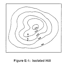
Walk from point A to point C on this map. Your trip
is all down hill
is all up hill
is down hill then up hill
is up hill then down hill

What is the elevation of Point A?
(a)

What is the elevation of point C?
(a)

What is the contour interval on this map?
(a)

Where is the steepest slope?
A
B
C
D
E

Where is the flattest area?
A
B
C
D
E


If sea level always equals (0), and the contour interval is 10 feet how tall is this mountain?
30 ft
40 ft
50 ft
60 ft


What is the special mnemonic
we use to remember the cardinal
directions?
even swans nest Wednesdays
never eat soggy weetbix
we never end school
every night we sing
direction?

What cardinal direction goes in the yellow box?
east
west
south
north

What cardinal direction goes in the yellow box?
north
south
east
west

What cardinal direction goes in the yellow box?
northeast
southwest
north
south

What cardinal direction goes in the yellow box?
west
east
southeast
northwest
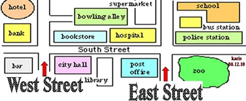
In which direction would you have to travel to go from city hall to the bowling alley?
What does the four main points on the compass is called?
Direction points
cardinal points
regional points

What direction would this person be traveling?
N
E
S
W

What direction would this person be traveling?
N
E
S
W

What direction would this person be traveling?
N
E
S
W

