
 Worksheets
Texas 1
Total questions: 20
Worksheet time: 12mins

Which region represents the Mountains and Basins region
red
yellow
green
blue
What physical feature affects why people settled in the Coastal Plains region?
mountains
valleys
deserts
nearby water source
Which are true about the Karankawa Indian tribe
famed for food and hunted buffalo
homes were made of animal hides and grass
used canoes
What characteristics are true about the Caddo tribe?
Grew corn beans and squash for food
lived in the southeastern region
lived in the coastal region
used dugout canoes for travel
When settlers arrived in Texas, they were mostly influenced by
water supply
land
animals
Which region has the most rain and longest COASTLINE in Texas?
Mountains and Regions
Coastal Plains Region
Flat, dry lands and large buffalo helped American Indians to
fish
hunt
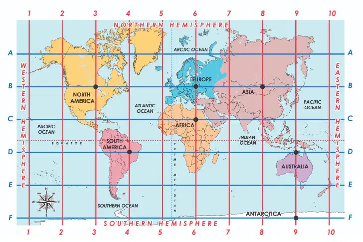
What country is located at (C,6)
AFRICA
EUROPE
ASIA
AUSTRALIA
Stephen F. Austin's colony was near
Rocky Mountains
Gulf of Mexico
Stephen F. Austin was
President
Empresario

The panhandle is located in what region?
Coastal
Great Plains
Mountains and Basins
North Central Plains

Based on the map, which number represents the Rio Grande River?
Number 2
Number 4
Number 5
Number 6
Gulf Coastal Plains = Coastal Plains
True
False
What is the capital city of Texas?
Dallas
Houston
Austin
San Antonio

What do both of these homes have in common?
Both travel easy
both are made of bark
absolute location
EXACT location of something
map creator
relative location
where something is in relation to something else
map creator
cartographer
map creator
Exact Location

Select the 4 regions of Texas.
(You must choose 4)
Mountains and Basins
Great Plains
North Central Plains
Central
Coastal Plains

