
 Worksheets
Ch. 1 The Geographer’s Toolbox Review
Total questions: 28
Worksheet time: 17mins
What is the Global Positioning System?
A) A satellite system used to find absolute location
B) A similarity between places
C) The center line of latitude
D) A mapmaker.
Which of the following is a similarity between places?
A) Geographic pattern
B) Absolute location
C) Prime meridian
D) Hemisphere
What is the study of the Earth's surface and the people who live there called?
Geography
Elevation
Projection
Longitude
Which line divides the Western Hemisphere from the Eastern Hemisphere and sits at 0° longitude?
Equator
Prime Meridian
Tropic of Cancer
Tropic of Capricorn
What is another name for lines of latitude?
Meridians
Parallels
Equators
Tropics
Which direction is opposite to Northeast?
Southwest
Northwest
Southeast
West
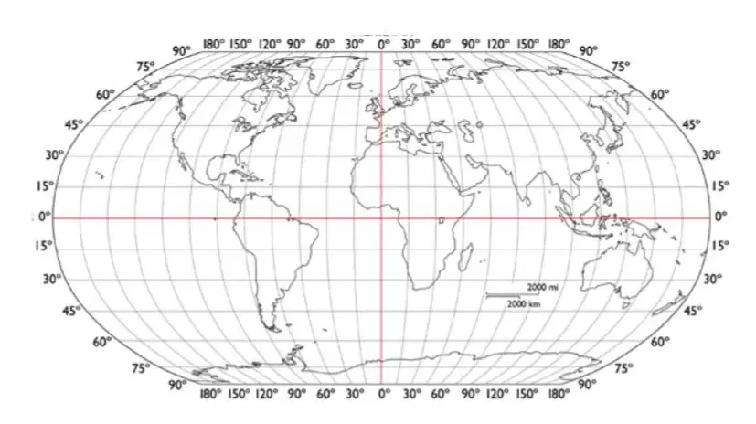
Which continent is located at 30°N, 90°E?
Africa
Asia
Europe
Australia
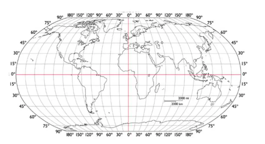
Which continent is located at 30S°, 60°W?
Africa
South America
Europe
Australia
Which ocean is located at 30N°, 30°W?
Arctic
Pacific
Atlantic
Southern
Which ocean is located at 10S°, 60°E?
Indian
Pacific
Atlantic
Southern
What is the best example of human-environment interaction?
Moving strawberries from the farm to Walmart to sell
cutting down trees to build a Walmart
the Oncue to next to the Walmart
Edmond has several Walmarts
How do cartographers show elevation?
color
compass rose
labels
locator globe
France is North of Spain.
Location
Place
Human-Environment Interaction
Movement
Regions
Soweto, South Africa is located at 26ºS, 27ºE.
Location
Place
Human-Environment Interaction
Movement
Regions
The average life expectancy in Italy is 77 years old.
Location
Place
Human-Environment Interaction
Movement
Regions
Which of the following is the best representation of earth?

Mercator Projection

Robinson Projection

Globe

Homolosine Projection
What measures the distance north and south of the equator?
Equator
Lines of Latitude
Prime Meridian
Lines of Longitude
map legend (key)
scale
The imaginary lines on a map that run east to west (horizontally).
North Pole
The starting point for measuring longitude and divides the Earth into the eastern and western hemisphere.
Which type of map would show the boundaries of countries?
political map
general-purpose map
land-use map
elevation map
What theme of geography explains the spread of religions around the world?
location
movement
region
Place
What map element would you use to figure out the distance from one city to another?
Legend
compass rose
scale
locator globe
What is the main difficulty with map projections?
They all contain some distortion.
They show only land, not water.
They make maps too large to carry.
they have no room for grid lines
What two hemispheres do we live in?
northern and eastern
northern and western
southern and eastern
southern and western
We are emphasizing Nehemiah 8:10 in class this year. This verse says, The ___________ of the Lord is your strength?
power
love
peace
joy

