wayground logo

Free Printable Worksheets

Font size

S
M
L
XL
Worksheets

7th Grade MAP SKILLS Review

Total questions: 70

Worksheet time: 23mins

Name
Class
Date
1.
Latitude lines run
a)
East to West
b)
North to South
2.
This line measures 0 degrees longitude:
a)
Equator
b)
International Date Line
c)
Meridians
d)
Prime Meridian
3.
The 0 degree line of latitude is the ___________.
a)
Equator
b)
Prime Meridian
c)
International Date Line
d)
Contour line
4.
What is the approximate location of letter B?
a)
80oN, 0o
b)
0o, 80oW
c)
80oS, 0o
d)
0o, 80oE
5.
What is the reason why latitude lines NEVER intersect? 
a)
They converge at the poles
b)
They are cool
c)
They are vertical lines 
d)
They are parallel
6.
Which letter would you find at 15oS, 60oW?
a)
A
b)
C
c)
L
d)
H
7.
What is this object known as?
a)
map symbol
b)
map key
c)
map scale
d)
compass rose
8.

Which ocean meets the EAST coast of the United States?

a)
Pacific Ocean
b)
Atlantic Ocean
c)
Arctic Ocean
d)
Indian Ocean
9.
How many oceans does Earth have? 
a)
2
b)
3
c)
4
d)
5
10.
Name Continent C!
a)
Antarctica
b)
Europe
c)
Asia
d)
North America
11.
Continent F is ________.
a)
Antarctica
b)
Australia
c)
Europe
d)
North America
12.
Continent G is ________.
a)
Asia
b)
Antarctica
c)
North America
d)
Europe
13.
Name Ocean #1!
a)
Indian
b)
Pacific
c)
Atlantic
d)
Southern
14.
Ocean #4 is ________.
a)
Indian
b)
Atlantic
c)
Pacific
d)
Southern
15.

Which of these continents is touched by the Prime Meridian?

a)
North America
b)
Africa
c)
Australia
16.
What is the latitude of New Orleans?
a)
90*W
b)
30*N
c)
30*W
d)
90*E
17.
A _______________ is exactly half of the earth.
a)
Equator
b)
Hemisphere
c)
Tropic of Cancer
d)
Arctic Circle
18.
Which continent is in all four hemispheres?
a)
Asia
b)
Europe
c)
Antarctica
d)
Africa
19.
What direction is indicated by the number 5?
a)
northeast
b)
northwest
c)
southeast
d)
southwest
20.
Which answer shows all of
the Intermediate Directions?
a)
South, North, East, West
b)
North, Northeast, Northwest
c)
Northeast, Southeast, Northwest,
Southwest
d)
South, Southeast, Southwest
21.
What is a map scale?
a)
a tool to measure distance
b)
a tool to tell direction
c)
a tool to start a fire
d)
a tool to build a house
22.
What kind of map is this?
a)
Continental
b)
Political
c)
Flat
d)
Globe
23.
A scale model of the earth
a)
Physical map
b)
globe
c)
Political map
Political Map
d)
Bar Scale
24.
Indicates the location of landforms like deserts, mountains, and plains
a)
Intermediate directions
b)
Prime Meridian
c)
Physical Map
d)
Map key/Legend
25.
Explains what the symbols on a map represent
a)
Bar Scale
b)
Map Key/Legend
c)
Compass Rose
d)
Parallels
26.

North, South, East and West are all called the ____________________

a)

middle directions

b)

cardinal directions

c)

four directions

d)

latitude

27.
Northeast, Southeast, Northwest, and Southwest are all known as ____________________ directions.
a)
main
b)
cardinal
c)
four
d)
intermediate
28.
What is the name of this object, which can be found on most maps?
a)
directions lily
b)
compass rose
c)
compass orchid
d)

legend

29.
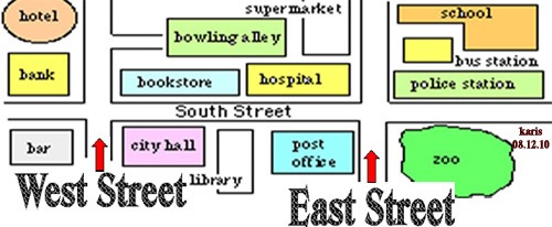
In which direction would you have to travel to go from the bank to the hospital?
a)
North
b)
South
c)
East
d)
West
30.

Which direction is the hotel from the zoo?

a)

North 

b)

South

c)

East

d)

West

31.

The museum is what direction from the school?

a)

Northeast

b)

South

c)

West

d)

Southwest

32.

Florida (FL) is ______ from Washington (WA).

a)

Northeast

b)

Southwest

c)

Northwest

d)

Southeast

33.
To go from New Jersey (NJ) to Florida (FL) you go _________. 
a)
North
b)
South
c)
East
d)
West
34.

To go from the cinema to the zoo, which direction would you go?

a)

Southeast

b)

North

c)

West

d)

Northwest

35.
Which state borders Ohio to the West?
a)
California
b)
Indiana
c)
Pennsylvania
d)
Michigan
36.

What are the four cardinal directions?

a)

east, west, northeast, southeast

b)

northwest, southwest, northeast, southeast

c)

north, south, east, west

d)

north, northwest, southwest, south

37.

This map feature tells you what the map is about.

a)

Title

b)

Scale

c)

Legend

d)

Key

38.

What tool would you use to measure the distance between two places on a map?

a)

key

b)

legend

c)

scale

d)

grid

39.

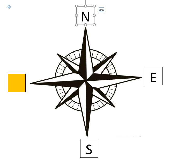
Which direction is missing?

a)

North

b)

East

c)

Southeast

d)

South

e)

Northeast

40.

Which direction is missing?

a)

North

b)

East

c)

Southeast

d)

South

e)

Southwest

41.

Which direction is missing?

a)

West

b)

Northwest

c)

Southeast

d)

South

e)

Southwest

42.

Which direction is missing?

a)

North

b)

Northwest

c)

Southeast

d)

Northeast

e)

Southwest

43.

What is this called?

a)

Compass Rose

b)

Map Key

c)

Map Scale

d)

Compass

44.
What is a map scale?
a)
a tool to measure distance
b)
a tool to tell direction
c)
a tool to start a fire
d)
a tool to build a house
45.

The cabins are _________ of the tents.

a)

North

b)

South

c)

East

d)

West

46.

What is a map legend?

a)

The part that explains the symbols and colors.

b)

The part that shows where the map is in the world.

c)

The part that shows the directions on a map.

d)

The part that shows how small the map is compared to land.

47.

What is the title of this map?

a)

North, South, East, West

b)

Political Map of the World

c)

Continents Map

d)

Countries of the World

48.

Eddie would walk ____________ to visit Lisa.

a)

north

b)

south

c)

east

d)

west

49.

On what street is the supermarket located?

a)

Dale Lane

b)

Main Street

c)

Twisted Lane

d)

Fifth Street

50.

What is the name of this continent?

a)

Australia

b)

Europe

c)

South America

d)

Africa

51.

What is the name of this continent?

a)

Europe

b)

Antarctica

c)

Asia

d)

North America

52.

What is the name of this continent?

a)

Africa

b)

Australia

c)

Asia

d)

Antarctica

53.

What is the name of this ocean?

a)

Atlantic Ocean

b)

Indian Ocean

c)

Pacific Ocean

d)

Southern Ocean

54.

What is the name of the ocean that is between Asia & North America?

a)

Arctic Ocean

b)

Indian Ocean

c)

Atlantic Ocean

d)

Pacific Ocean

55.

What is the name of this continent?

a)

South America

b)

North America

c)

Africa

d)

Asia

56.

What is the name of this continent?

a)

Europe

b)

Antarctica

c)

Australia

d)

Asia

57.

What is the name of this continent?

a)

North America

b)

South America

c)

Antarctica

d)

Europe

58.

What is the name of this continent?

a)

Antarctica

b)

Australia

c)

Europe

d)

Africa

59.

What is the name of this ocean?

a)

Atlantic

b)

Pacific

c)

Indian

d)

Arctic

60.

Is the Arctic Ocean in the north or south?

a)

North

b)

South

61.

What hemisphere is shown?

a)

North

b)

East

c)

South

d)

West

62.

What hemisphere is shown?

a)

North

b)

East

c)

South

d)

West

63.

What continent is in all 4 hemispheres?

a)

Asia

b)

Europe

c)

Australia

d)

Africa

64.

Which hemisphere is shown?

a)

North

b)

East

c)

South

d)

West

65.

What hemisphere is shown?

a)

North

b)

East

c)

South

d)

West

66.

What two hemispheres do we live in?

a)

North

b)

East

c)

South

d)

West

67.

Russia is a continent.

a)

True

b)

False

68.

The United States of America is a continent.

a)

True

b)

False

69.

The United States is the only country in North America.

a)

True

b)

False

70.

What is the correct order for the cardinal directions, when going clockwise?

a)

East, West, South, North

b)

West, East, South, North

c)

South, East, West, North

d)

North, East, South, West