
 Worksheets
River Landforms
Total questions: 83
Worksheet time: 45mins

What landform can you see in the picture?
U shaped valley
V Shaped Valley
Floodplain
Waterfall

Which landform can be seen in the photo?
Waterfall
Estuary
Inter-locking Spur
Meander

What landform can you see in this picture?
Waterfall
V Shaped Valley
Meander
Ox-bow lake
What is the deep water called beneath a waterfall?
Plunge bath
Mermaids retreat
Plunge pool
Pool
Waterfalls - what is the gap called between the hard and soft rock created by erosion?
Deadman's drop
Hole
Erosional gap
Overhang
Which two erosional processes create waterfalls?
Solution
Abrasion
Hydraulic Action
Attrition

Name this waterfall
Low Force
Medium Force
High Force
Kelly's Waterfall

What landform can you see in the picture?
Meanders
Rapids
Estuary
V shaped valleys

What landform is created on the inside bend (...) of a meander and why?
A slip off slope or river beach which is caused by erosion due to fast flowing water.
A slip off slope or river beach which is caused be deposition due to slow flowing water.
A deposit beach caused by deposition
An erosional beach caused by erosion

What landform can be found on the outside bend of a meander(*) and why?
A river cliff as the water flows slowly and deposits the load it is carrying.
A river cliff as the water flows quickly on the outside bend eroding the bank through attrition.
A river cliff
A river cliff as the water flows quickly on the outside bend eroding the bank through hydraulic Action.

What two landforms can you see in the picture?
Meander and V shaped valley
Waterfall and gorge
Meander and Ox-bow lake
Estuary and floodplain

What landform can you see in the middle of the picture?
Estuary
Meander
Levee
Ox-bow Lake

What is the land next to the river called and how would you describe it?
Floodplain, steep land next to the river.
Floodplain, flat land next to the river.
Floodplain, flat land away from the river.
Floodplain, flat land on top of the river.

What landform can you see in this picture and what process created it?
Ox-bow lake, created by erosion and deposition on a meander bend.
Waterfall, created by erosion of hard and soft rock.
Estuary, created by erosion as the river meets the sea.
Estuary, created by deposition as the river meets the sea.
What landform can you see in the picture?
U shaped valley
V Shaped Valley
Floodplain
Waterfall
What landform can you see in this picture?
Waterfall
V Shaped Valley
Meander
Ox-bow lake
What is the deep water called beneath a waterfall?
Plunge bath
Mermaids retreat
Plunge pool
Pool
Which two erosional processes create waterfalls?
Solution
Abrasion
Hydraulic Action
Attrition
What landform can you see in the picture?
Meanders
Rapids
Estuary
V shaped valleys
What two landforms can you see in the picture?
Meander and V shaped valley
Waterfall and gorge
Meander and Ox-bow lake
Estuary and floodplain
What landform can you see in the picture?
U shaped valley
V Shaped Valley
Floodplain
Waterfall
What landform can you see in this picture?
Waterfall
V Shaped Valley
Meander
Ox-bow lake
What is the deep water called beneath a waterfall?
Plunge bath
Mermaids retreat
Plunge pool
Pool
What is the land next to the river called and how would you describe it?
Floodplain, steep land next to the river.
Floodplain, flat land next to the river.
Floodplain, flat land away from the river.
Floodplain, flat land on top of the river.
What landform can you see in this picture and what process created it?
Ox-bow lake, created by erosion and deposition on a meander bend.
Waterfall, created by erosion of hard and soft rock.
Estuary, created by erosion as the river meets the sea.
Estuary, created by deposition as the river meets the sea.


Attrition is when ..
large rocks smash against each other.
small rocks rub against the river bed.
sand and other fine particles float.
water flows into the rocks.


On a meandering river where does the water flow the fastest?
On the inside of meanders
In the middle of the stream
On the outside of meanders
What is a meander?
A type of waterfall
A bend in the river
A type of delta
A straight section of the river
What is a delta?
A type of waterfall
A bend in the river
A landform formed at the mouth of a river
A type of valley
What type of valley is typically found near the source of a river?
U-shaped valley
V-shaped valley
W-shaped valley
S-shaped valley
What process narrows the gap between the curves of a meander, eventually forming an oxbow lake?
Erosion
Deposition
Transportation
Abrasion
What is the process of erosion where a river cuts into the soft riverbank, forming a v-shaped valley?
Attrition
Abrasion
Hydraulic Action
Vertical Erosion

What is the name given to material deposited in a flood plain?
Aluminium
Boulders
Alluvium
Gorge
When a delta forms, the river breaks up into a number of smaller rivers called ......................
Distributaries
Confluences
Tributaries
Waterfalls
How are meanders formed in a river?
Meanders are formed in a river due to gravitational pull.
Meanders are formed in a river due to erosion and deposition processes.
Meanders are formed in a river due to magnetic fields.
Meanders are formed in a river due to volcanic activity.
What is the formation process of oxbow lakes in a river?
Oxbow lakes are formed by glacier movement
Oxbow lakes are formed by underground springs
Oxbow lakes are formed when a meander in a river is cut off, usually during a flood, creating a U-shaped body of water separate from the main river channel.
Oxbow lakes are formed by volcanic activity
Explain how waterfalls are formed in the upper course of a river.
Waterfalls are formed in the upper course of a river due to lack of water flow
Waterfalls are formed in the upper course of a river due to excessive sedimentation
Waterfalls are formed in the upper course of a river due to volcanic activity
Waterfalls are formed in the upper course of a river due to differential erosion between hard and soft rock layers, creating a step in the riverbed where water plunges downwards, leading to the formation of a waterfall.
Describe the formation of V-shaped valleys in a river.
V-shaped valleys are a result of tectonic plate movement
V-shaped valleys in a river are formed through erosion by the flowing water over time, cutting down into the land and creating a V-shaped profile.
V-shaped valleys are formed by volcanic activity
V-shaped valleys are created by wind erosion
What causes the outer bank of a meander to erode?
Higher velocity of water on the outside curve of the bend
Lower velocity of water on the outside curve of the bend
Presence of vegetation stabilizing the bank
Decreased sediment load in the water
How does the flow of water contribute to the shaping of V-shaped valleys?
The flow of water has no impact on valley formation.
The flow of water causes the valley to widen.
The flow of water erodes the sides of the valley.
The flow of water creates flat valleys.
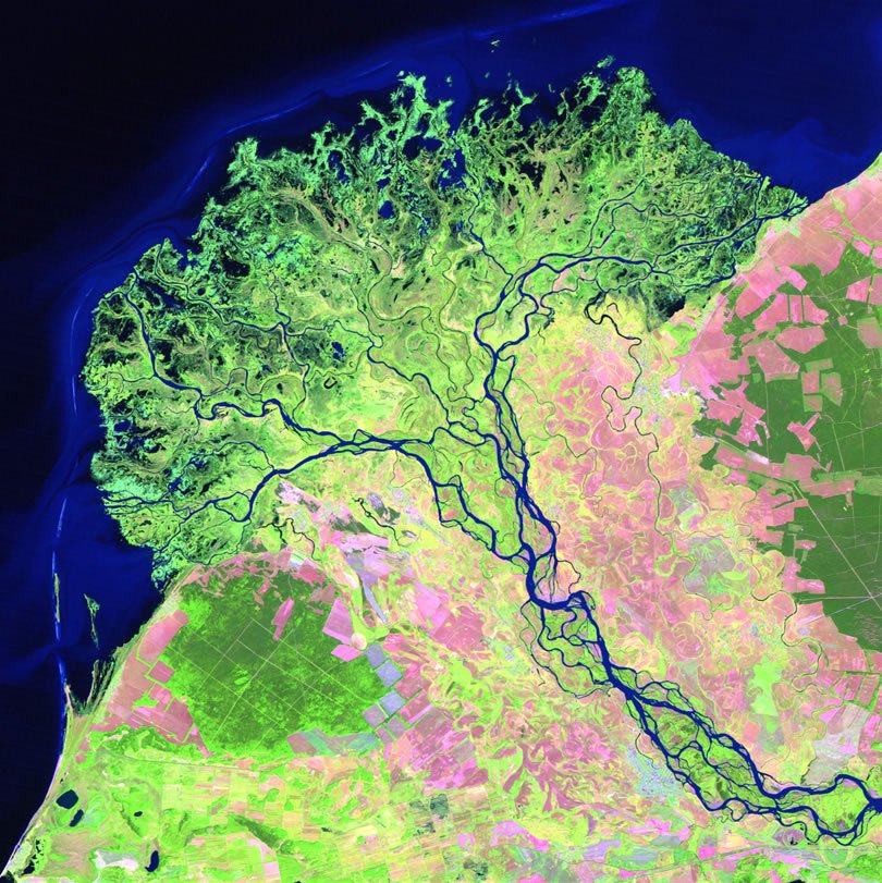
Which of these features would you NOT expect to find in the upper course of a river?
Braiding
Interlocking spurs
Waterfalls
Rapids
As a waterfall retreats upstream, it creates a feature called:
A V-shaped valley
Interlocking spurs
A river cliff
Gorge
Natural embankments created alongside a river are known as:
Interlocking spurs
Deltas
Levees
Flood plains
A piece of land which formed as a result of a river depositing sediment into the sea is called:
A delta
A levee
An example of braiding
An ox bow lake An ox bow lake
In the lower course mostly ___________ takes place.
Erosion
Transportation
Deposition
Traction

In the upper course which process is dominant?
(a)

In the lower course which process is dominant?
(a)

In the upper course (a) erosion is dominant

In the lower course (a) erosion is dominant

What is it called when new land is formed by deposition at the end of a river?
estuary
levee
floodplain
delta
What landform can you see in the picture?
U shaped valley
V Shaped Valley
Floodplain
Waterfall
What landform can you see in the picture?
Meanders
Rapids
Estuary
V shaped valleys
What two landforms can you see in the picture?
Meander and V shaped valley
Waterfall and gorge
Meander and Ox-bow lake
Estuary and floodplain
Why do rivers become wider downstream? (Select all that apply)
There is more lateral erosion
Tributaries feed the rivers more water
There is more space for them to spread out
They carry more sediment
Which type of erosion is more common in the middle course of a river?
Vertical
Lateral
What feature is being described here? The inside bank of a meander on a river where sedimentary material is deposited as a result of the slower flow rate
Overhang
River cliff
Slip-off slope
Meander
When energy levels drop in a river, which type of sediments are deposited first?
Large, heavy sediments
Small, very fine sediments
Sand/silt sediments
Pebbles and small rocks

What would the river channel look like from B to B'


What would the river channel look like from A to A'


What would the river channel look like from C to C'


What factor(s) determine a river's ability to erode sediment?
Velocity
Gradient
Discharge
Stream Channel Shape
When a meander's bends are close together, they may join when ....
The river dries up
The river gets slower
The river floods
The river changes direction
An ox-bow lake is formed after the river .....
Stays the same
Meanders
Takes the straightest path after flooding
Dries up

Deposition on the inside of a river creates a...
River cliff
River bed
Erosion
Slip-off slope
Deposition (dropping of sand and pebbles) happens when a river is
Fastest
Slowest
Widest
Deepest

