
Font size
 Worksheets
Geo Test
Total questions: 79
Worksheet time: 58mins
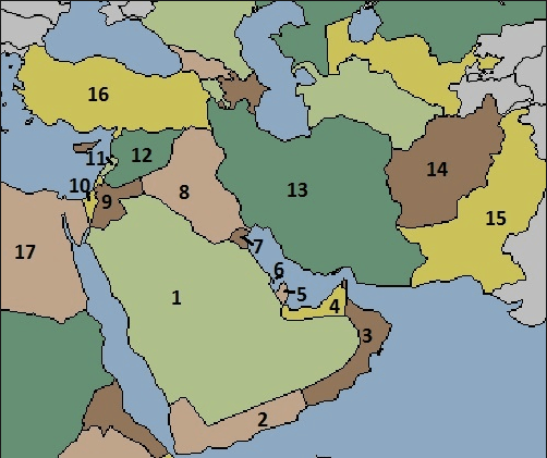
_________ are the most common physical feature here and make up 66% of the area.
Mountains
Deserts
Plateaus
Grasslands
Which best describes the climate of much of Southwest Asia?
Hot and dry
Windy and cold
Tropical and rainy
Moderate and cool
The climate of Southwest Asia has led much of the region to experience a scarcity of _____________.
Trading
Rainfall
Oil production
Desalination plants
This 25-mile territory has been a source of dispute between Israel and its neighbors for many years:
Gaza Strip
Persian Gulf
Strait of Hormuz
Suez Canal
Why is the Suez Canal so important to international shipping?
It allows ships to get out of the Persian Gulf.
It is Iraq’s only waterway to the Persian Gulf.
It connects the Jordan River to the Persian Gulf, making it cheaper to ship oil to other parts of Southwest Asia.
It makes it possible to get from the Mediterranean to the Red Sea without sailing around Africa.
Which rivers flow through Turkey and Iraq?
Jordan and Tigris
Jordan and Euphrates
Tigris and Euphrates
Red and Jordan
Disputes over what two natural resources are problematic for many Southwest Asian countries?
Oil and Water
Water and Diamonds
Diamonds and Natural Gas
Oil and Diamonds
What are three major water problems in Southwest Asia?
Water shortages, unequal distribution, pollution
Flooding, pollution, dams
Too much ground water, aquifers, pollution
Water shortages, flooding, pollution
What non-renewable natural resource has contributed to the growth of the Middle East?
Oil
Water
Timber
Cotton
The process of removing salt from salt water in order to make it suitable for farming and drinking is known as
Desalination
Naturalization
Absorption
Extraction
Because of its harsh climate, which country has to rely on desalination plants to provide most of its citizens’ drinking water?
Israel
Turkey
Saudi Arabia
Syria
This area holds one of the largest and most important oil fields in the world.
All of the countries that produce oil in that region depend on it as a shipping route.
Persian Gulf
Arabian Sea
Dead Sea
Red Sea

What's the most Northern River in the Middle East? (It has a twin river)
(a)



What is an ice age ?
Line on a map joining places that are the same height above sea level
the change from liquid to gas
the time where earth's average temperature was lower than usual and glaciers spread
a sheet of ice that is attached to land, but floats on the ocean
What is Tundra ?
A type of plant or animal
A cold region where the ground is deeply frozen; only the surface thaws in summer, allowing small plants to grow.
The average number of people living in a place, per square kilometre
A map of a small area
Which of the following is an iceberg ?


How are glaciers formed ?
Rain turned into snow
Layers of snow are compressed.
Hot air convects and form snows.
Long winter
Why did glaciers flow ?
Force of gravity
Pressure of the glacial's weight
All of the above
What is crevasses ?


Cracks in the glaciers are called.....
Crevasses
Ice Cracks
Ice Shelf
Ice Berg
Moraine found along the sides of a glacier is
Side moraine
Lateral Moraine
Terminal Moraine
Medial Moraine
Pyramidal Peaks are in the shape of a
Circle
Square
Cube
Triangle

What type of erosion is this?
Freeze Thaw
Abrasion
Plucking

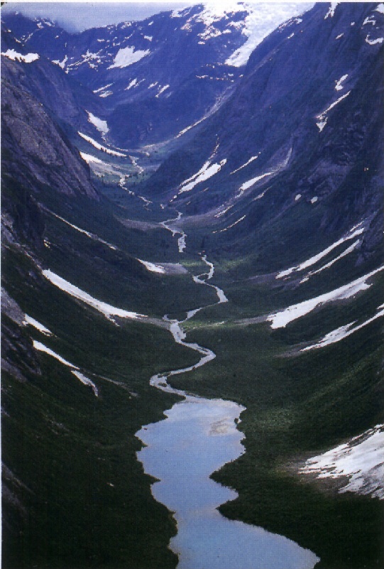
What landform is shown in the image?
Arete
Cirque
Erratic
Till

Large rocks or boulders that are transported by glaciers are called...
striations
erratics
till
abrasions
When two corries form side by side, it will leave a sharp ridge of rock called...
Moraine
Arete
Pyramidal Peak
Snowball

Abrasion is:
parallel and straight scratches cut into bedrock by a glacier.
a process of erosion which occurs when material being transported wears away at a surface over time.
the transportation of large rocks and boulders
a ridge at the edge of a glacier where rocks and sediment are deposited

Unsorted sediment or pebbles, sand, clay, etc. that is transported and deposited by glaciers is called:
striations
erratics
till
abrasions
Where are glaciers found today?
Equator regions
Coastal areas
Polar regions and high mountains
Deserts

What type of erosion is this?
Freeze Thaw
Plucking
Abrasion

What type of erosion is this?
Freeze Thaw
Plucking
Abrasion
Where can convection currents be found?
inner core
outer core
mantle
crust
Which layer of the earth is divided into pieces called tectonic plates?
inner core
outer core
mantle
crust
Why do the tectonic plates move?
ocean currents in the hydrosphere
winds in the atmosphere
gravity
convection currents in the mantle
In which type of plate boundary do the tectonic plates move apart?
conservative or transform
constructive or divergent
destructive (collision zone)
destructive (subduction zone)
Which type of plate boundary involves one piece of oceanic crust sliding under a piece of continental crust
conservative or transform
constructive or divergent
destructive (collision zone)
destructive (subduction zone)
Where is the Ring of Fire
round the Atlantic Ocean
round the Pacific Ocean
Round the Mediterranean Sea
Around the Himalayan Mountains
Which is an example of a convergent plate boundary (collision zone)
Mid-Atlantic Ridge
West coast of Mexico
San Andreas Fault in California
Himalayas
When do fold mountains form?
when plates collide or move towards each other
when plates slide past each other
when plates move apart
Which scale is used to measure earthquakes?
Richfort
Decimal
Beaufort
Richter
What is the name for the place where an earthquake originates below the ground?
Richter
crust
focus
epicentre
What is the name of the instrument used to measure earthquake waves?
barometer
thermometer
anemometer
seismometer
Which is an example of a secondary effect of an earthquake?
lava bombs
tsunami
houses collapse
deaths
What is the name of the tube that lava rises through in a volcano?
crater
magma chamber
vent
magma
Which mountain range does not have volcanoes?
Himalayas
Andes
Sierra Madre


The point on Earth's surface above where an earthquake occurs is the (a) .
The evidence is in ______________________, where coastlines and mountain ranges appear to fit together like a puzzle all over the world
Continental drift
Plate Tectonics
The Rock Cycle
Divergent boundaries
This plate boundary moves land apart, creating an ocean trench or a valley on land : ________________________
Divergent boundary
Transform boundary
Convergent boundary
Mid-Ocean voundary
This tectonic plate boundary creates mountain ranges: ____________________
Divergent boundary
Convergent boundary
Transform boundary
Mid-oceanic boundary
Which tectonic plate boundary SLIDES past each other...
Divergent
Convergent
Transform
Continental
An ocean trench is the same as a __________ on land.
Mountain
Valley
Earthquake
Volcano
Weathering is:
areas of old rock that make up the majority of continents.
when wind, water, and/or ice gradually wear down landforms.
made or caused by only human activity.
made or caused by only natural activity.
Erosion:
shows the elevation above sea level on a map.
is formed by water and glacial erosion.
is when wind, water, and/or ice carry material from one place on the earth’s surface to another.
is the earth's solid outer crust, made up of moving plates.
Valleys:
show the elevation above sea level on a map.
are formed by water and glacial erosion.
are when wind, water, and/or ice carry material from one place on the earth’s surface to another.
are the earth's solid outer crust, made up of moving plates.
Contour lines:
show the elevation above sea level on a map.
are formed by water and glacial erosion.
are when wind, water, and/or ice carry material from one place on the earth’s surface to another.
are the earth's solid outer crust, made up of moving plates.
Landforms are:
The tectonic plates rub past each other.
the natural features that make up Earth’s surface
The earth's outer, solid crust, made up of moving plates.
Wind water and ice disintegrate rock

