
 Worksheets
Canadian Geography & Natural Regions
Total questions: 81
Worksheet time: 1hrs 15mins

What is letter G
The Rocky Mtns
Hudson Bay
Stl Lawrence Seaway
Canadian Shield

What is letter H?
Pacific Ocean
Hudson Bay
Atlantic Ocean
Arctic Ocean

What is letter I?
Pacific Ocean
Arctic Ocean
Atlantic Ocean
Hudson Bay

What is the letter F?
USA
St. Lawrence Seaway
Rocky Mountains
Canadian Shield

What is letter B?
Alaska
Rocky Mtns
USA
Canadian Shield

What is letter D?
USA
Great Lakes
Canadian Shield
St Lawrence Seaway

What is letter E?
Arctic Ocean
Canadian Shield
Hudson Bay
Great Latkes
What mountain range do U.S. and Canada share to the west?
Appalachian Mtns
Belize Mountains
Arctic Mountains
Rocky Mountains
Minerals such as nickel, copper, silver, zinc, and uranium are found in the
Great Lakes Region
Beneath the Hudson Bay
Throughout the Canadian Shield
On the Interior Plains
Which one is a plateau?


What do you call a valley?
A raised area of land that is very tall and rocky
A dry area of land that gets very little rain
A low area of land between hills or mountains
A large area of flat land
What defines a mountain?
A raised area of land that is very tall and rocky
A raised area of land that is flat and has a steep drop on at least one side
A raised area of land that is not as tall as a mountain
A low area of land between hills or mountains
Which of the following is a non-renewable fossil fuel used for powering machines and generating electricity?

Fish

Oil

Water

Coal
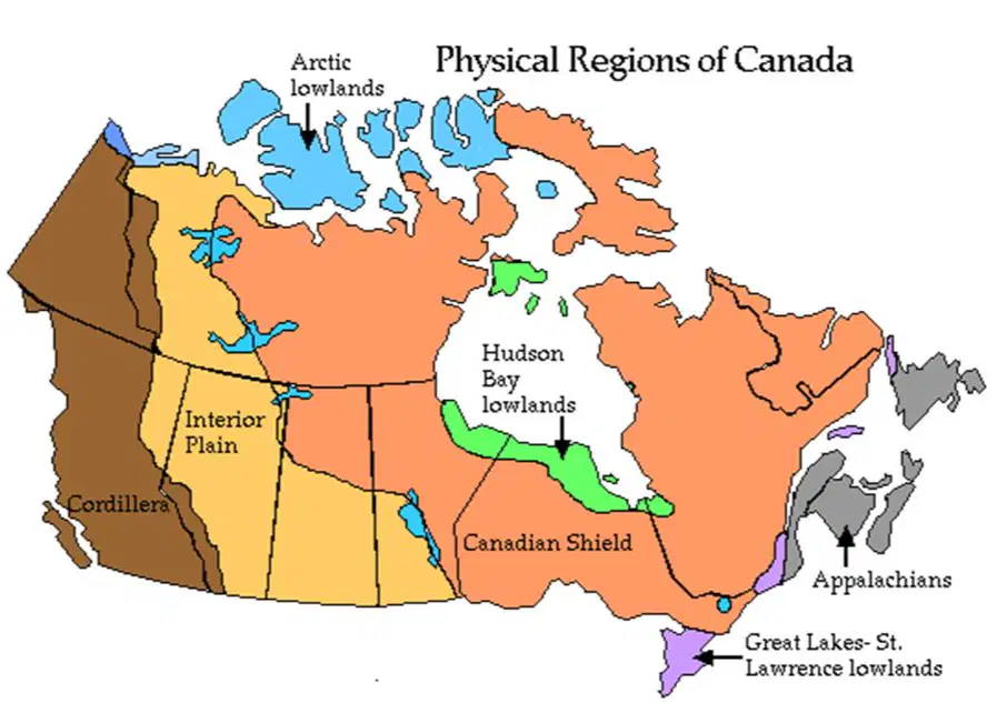
Where is the Western Cordillera located?
East coast of Canada
West coast of Canada
North coast of Canada
South coast of Canada
Which political regions does the Western Cordillera cover?
All of Alberta
Most of Quebec
All of Ontario
Most of the Yukon and British Columbia, as well as parts of the Northwest Territories and Alberta
What are the main landforms found in the Western Cordillera?
Deserts and forests
Mountains, plateaus, plains, valleys
Islands and lakes
Coral reefs
How would you describe the coastal climate of the Western Cordillera?

Extremely Hot and Dry

Mild and wet, very little snow

Cold with heavy snowfall

Tropical with frequent hurricanes
All forms of moisture and include rain, snow, sleet, hail, and fog
precipitation
climate
physical
human

The map was created to show human created boundaries that separate provinces and territories. What type of map is this?
It is a political map.
It is a thematic map.
It is a physical map.
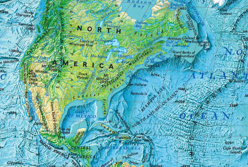
The map is shows different heights of land. What type of map is this?
It is a political map.
It is a thematic map.
It is a physical map.
This geographical region has the most ancient surface rock on Earth.
Canadian Shield
Interior Plains
The Great Lakes
Arctic Region
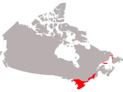
Which region does the red show?
Canadian Shield
Interior Plains
Great Lakes/St. Lawrence Lowlands
Mountain Regions
Most of this region lives in Edmonton, Calgary, Saskatoon, Regina, and Winnipeg.
Canadian Shield
Interior Plains
Ontario
British Columbia
Ranching and farming is popular in this region.
Canadian Shield
Interior Plains
Ontario
British Columbia
Studying the Earth's surface, climate, natural resources, and how how people interact with those features.
geography
physical features
landforms
gym


What is the climate like in the Great Lakes and St. Lawrence Region?
Hot summers and mild winters
Warm summers and cold winters
Mild summers and harsh winters
Dry summers and wet winters
What type of climate does the Atlantic Region generally have?
Hot and dry
Cool and moist
Warm and humid
Cold and dry

SS6G5 How has climate affected where Canadians live?
Few people live in the northern regions of Canada because of the cold climate.
Few people live along the border of Canada and the United States because of cold climate.
Most people tend to migrate and live in the northern provinces of Canada.
Most people tend to migrate toward Great Bear Lake and Great Slave Lake.
SS6G5 Timber, minerals, fresh water, wheat, and fish are all examples of Canada's
provinces
population distribution
natural resources
trade barriers
SS6G5 Canada is the world’s second largest country in terms of land area. However, about 75% of Canada’s population lives within 100 miles of its southern border. Which of the following statements is a reason why so many Canadians live in their country’s southern region?
Canadian law encourages people to live in its southern region.
Canada’s southern region has a milder climate, is closer to the U.S. for travel and trade, and can offer more jobs than its northern region.
Canada's northern regions have dangerous wild-life which poses a threat to citizen safety.
Canada's section of the Great Lakes are too polluted.
SS6G6 Which is probably the largest environmental concern near the Canadian Shield?
dams
radiation from a nuclear meltdown
exporting raw materials
mining and logging
Which Physical Region has glaciers and a very cold climate?
(a)
Which physical region is the largest region in Canada, and includes plateaus, bare rock, and forests?
(a)


Alberta
Nunavut
Northwest Territory

Alberta
British Columbia
Quebec

Hudson Bay
St. Lawrence River
Gulf of Mexico

Ontario
Manitoba
Newfoundland & Labrador

Yukon Territory
Nunavut
Northwest Territory

Nunavut
Ontario
Saskatchewan

Saskatchewan
Ontario
British Columbia

Alberta
Manitoba
Quebec

Saskatchewan
Yukon Territory
Nunavut

Quebec
Ontario
Yukon Territory
Weather is:
experienced on a daily basis
measured in years
none of the above
all of the above
Precipitation includes:
Rain
Snow
Hail
All of the above
True or false: Climate can influence the types of buildings that are built in a city.
True
False
The closer you are to the equator, the colder it gets.
True
False
Oceans do not ________ down or _________ up as fast as land does.
go, move
spin, twirl
cool, heat
snow, sunshine
Moving away from the ocean means higher or lower elevation?
higher
lower

Based on the map, which of the following is a major natural resource of Alberta?
oil
gold
timber
iron
All three Indigenous groups of the Atlantic travelled from place to place depending on the weather. This is called...
Nomadic
Traveller
Tourist
Explorer
Who are the main groups of the Atlantic region?
Haudenosaunee and Ouendat
Haida and Salish
Inuit
Maliseet, Mi'kmaq and Beothuk
What were the homes of the Mi'kmaq called?
Tent
Tipi
Wigwam
Longhouse
Who were the First Nations of the Great Lakes region?
Haida and Salish
Inuit
Haundenosaunee and Ouendat
Woodland, Anishinabe, and Innu
This group were the first to collect maple syrup
Haida
Inuit
Haudenosaunee
Cree
Which three vegetables were planted to create the "Three Sisters"?
Cucumber, beans, broccoli
Pumpkin, pepper, corn
Corn, beans, squash
Tomato, squash, beans
What were the houses called that the Haudenosaunee and Ouendat lived in?
Pit houses
Tipis
Longhouses
Iglus
In the Canadian Shield, the Innu particularly hunted which animal?
Bison
Deer
Caribou
Bear
The Innu were the first to invent which item that we still use today in the snow?
Toboggan
Maple Syrup
Longhouse
Snorkels
Which group lives in the Arctic?
Haida
Inuit
Cree
Maliseet
The traditional land of the Inuit is now in which territory of Canada?
Yukon
Nunavut
Northwest Territories
Which animals were particularly useful for the Inuit to make warm clothing and use for cooking oil?
Seal and walrus
Bear and caribou
Duck and geese
What were the winter homes of the Inuit called?
Longhouses
Pit houses
Iglus
Tents
This item helped the Inuit with travel. They even used dogs to help put it along
Toboggan
Sledge
Snowmobile
This item can grow in the Arctic
Oranges
Cranberries
Apples
Strawberries
These are the main groups of the Interior Plains
Blackfoot, Dene, and Cree
Haida and Salish
Maliseet, Mi'kmaq, Beothuk
Haudenosaunee and Ouendat
The First Nations of the Interior Plains particularly hunted which animal?
Caribou
Bear
Bison
Moose
This animal only came to the Interior Plains region a few hundred years ago. It helped for the First Nations to hunt and travel with.
Dog
Wolf
Horse
Deer
Which First Nation in the Cordillera lived along the coast and were closely connected to the ocean?
Haudenosaunee
Haida
Inuit
Cree
Bonus: These tall carved structures can primarily be found in the Cordillera region
Totem poles
Tipis
Canoe

