
NEW
Font size
S
M
L
XL
 Worksheets
OS Maps questions
Total questions: 15
Worksheet time: 10mins
Name
Class
Date
1.

What does this symbol represent on an OS map?
a)
Byway
b)
Bridleway
c)
Footpath
d)
Motorway
2.

What type of road is this on an OS map?
a)
Main Road
b)
Secondary Road
c)
Road less than 4m wide
d)
Dual Carriageway
3.

What type of road is this on an OS map?
a)
Main Road
b)
Secondary Road
c)
Motorway
d)
Road less than 4m wide
4.

What type of road is Orange on an OS map?
a)
Main Road
b)
Secondary Road
c)
Motorway
d)
Road less than 4m wide
5.

What type of road is coloured yellow on an OS map?
a)
Main Road
b)
Secondary Road
c)
Motorway
d)
Road less than 4m wide
6.

What does this symbol in the image show?
a)
Pub
b)
Petrol Station
c)
Glass factory
d)
Water station
7.
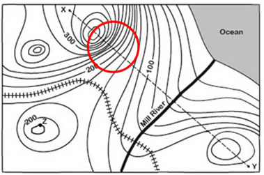
What do close contour lines represent on a map?
a)
waterfall
b)
steep area
c)
flatter area
d)
river
8.
Where do we measure the height of the land from?
a)
The nearest part of flat land
b)
The centre of the earth
c)
Sea ;
Sea level
Sea level
9.

What is the elevation of point B?
a)
800 ft
b)
850 ft
c)
900 ft
d)
1000 ft
10.

a)
grassland
b)
deciduous wood
c)
coniferous wood
d)
military zone
11.

a)
danger of lightning
b)
electricity pylon
c)
mast
d)
windmill
12.

What does this map symbol represent?
a)
Church with a tower
b)
Church with a spire
13.
Which is the more detailed map, 1:25000 or 1:50000?
a)
1:25000
b)
1:50000
14.

What is the six-figure grid reference for the campsite in Cranstock?
a)
815614
b)
806604
c)
614815
d)
851635
15.

What does this map symbol represent?
a)
Campsite
b)
Caravan Site
c)
Public Toilet
d)
Picnic Site
Reset

