
Font size
 Worksheets
7th Grade Geography Concepts
Total questions: 33
Worksheet time: 22mins
Which of the following maps would have the least amount of distortion and be the best representation of true Earth?
Mercator Map
Globe
Robinson Projection Map
Topographic Map
These are called: Movement of People, Goods & Services, Region, Human-Environment Interaction, Location: Absolute & Relative Place
Historical Studies
Themes of Geography
Basic Map Skills
Gross Domestic Products of a Country
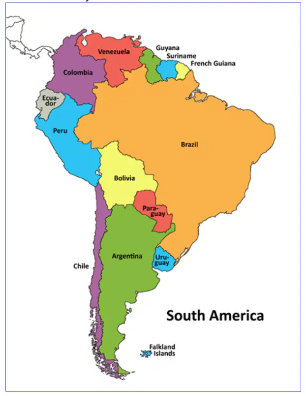
What are the only countries in South America that do not border Brazil?
Ecuador
French Guinea
Paraguay
Colombia
Chile
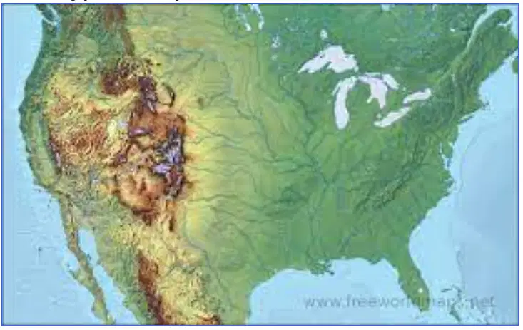
What type of map is featured below?
Political Map
Climate Map
Physical Map
Vegetation Map
What do latitude and longitude lines help geographers identify?
to find relative location
to measure the depths of the ocean
to find absolute location
to determine the elevation of mountains
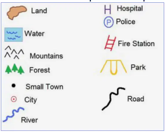
What do we call the part of a map that explains the symbols and the colors?
scale
map key
title
glossary
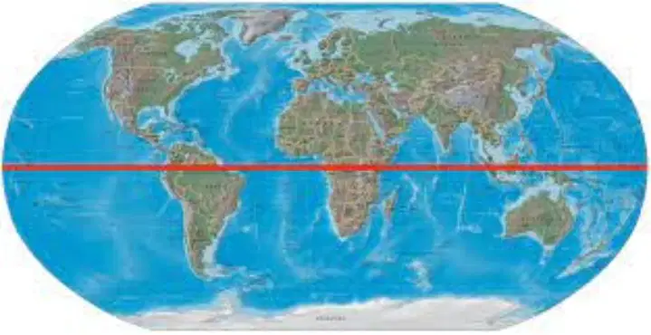
What is the name of the dividing line in red on this world map?
International Date Line
Prime Meridian
Arctic Circle
Equator
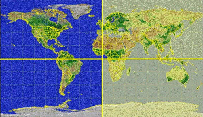
Which hemisphere is highlighted in yellow on this world map?
Northern
Eastern
Southern
Western

What type of climate is located in the majority of the Southeastern part of the US? (hint: keep in mind the map is curved)
Semiarid
Tropical Wet
Humid Subtropical
Marine West Coast
What characteristic of a region can end up dividing the people who live within the region?
the people using the same language
the people practicing the identical religion
the people sharing a similar cultural identity
the people belonging to different ethnic groups

What physical features runs down the west coast of South America?
Amazon River
Strait of Magellan
Brazilian Highlands
Andes Mountains
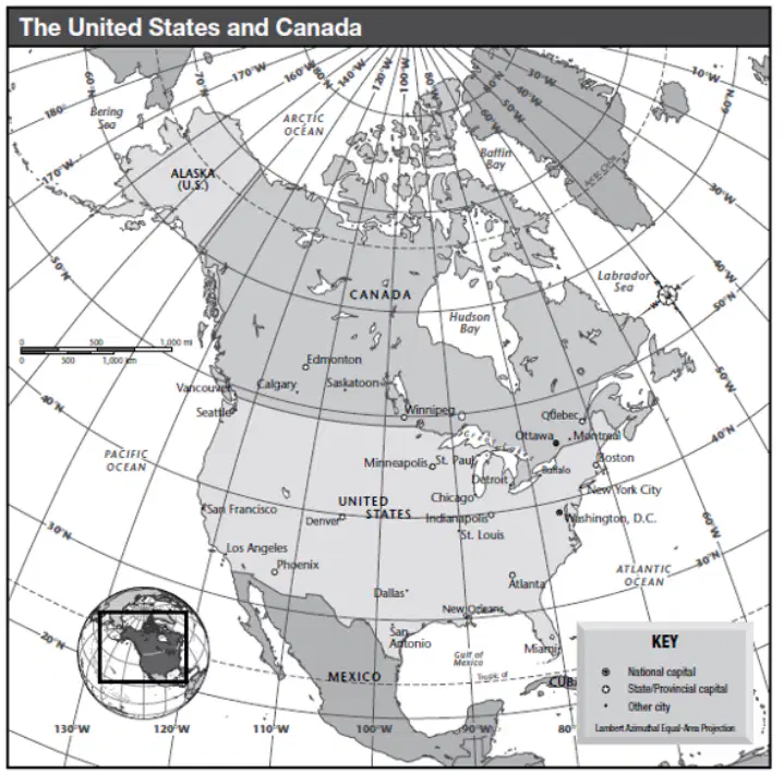
What is the relative location of New Orleans?
near Gulf of Mexico between Atlanta and Dallas
northeastern region of USA north of Washington D.C.
close to the Pacific Ocean
around Phoenix in the southwestern region
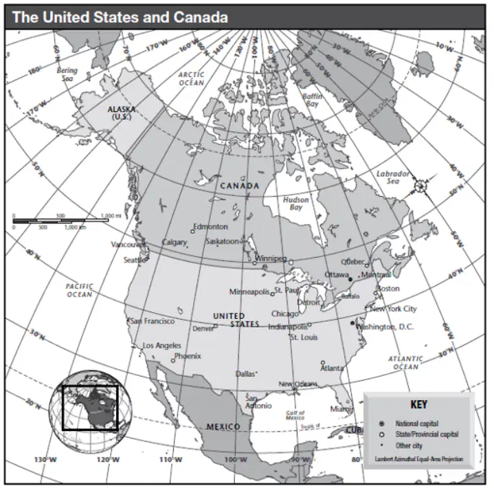
What is the latitude and longitude coordinates of New Orleans, Louisiana?
40 degrees North and 100 degrees West
40 degrees North and 80 degrees West
30 degrees North and 90 degrees West
30 degrees North and 100 degrees West
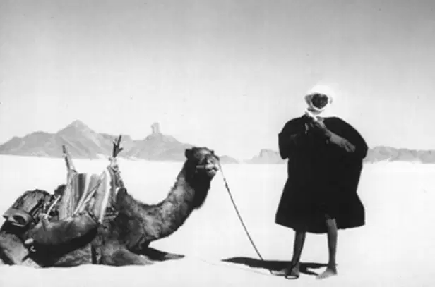
What type climate is represented in this photograph?
Humid Subtropical
Arid
Mediterranean
Highland
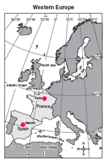
The map scale can help you determine the distance between 2 locations. What is the estimated distance between Paris, France and Madrid, Spain?
300 miles
600 miles
900 miles
1,200 miles

The map below shows the global distribution of tropical rainforests around the world. What continent has the largest area of Tropical Rain?
Europe
Asia
South America
Australia / Oceania
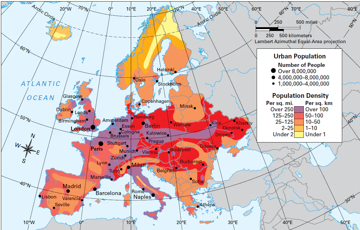
Which region of Europe is the least densely populated?
Mediterranean
British Isles
Iberian Peninsula
Scandinavia
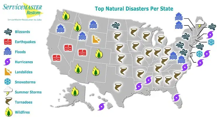
Which natural disaster is most likely to occur in the Great Plains region of the United States?
Earthquake
Wildfire
Tornado
Hurricane
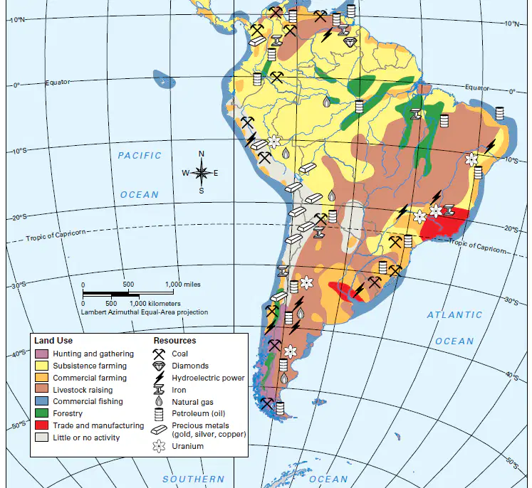
Which South American country has ALL of the following: Uranium, Iron, Petroleum with Trade and Manufacturing?
Chile
Colombia
Brazil
Peru
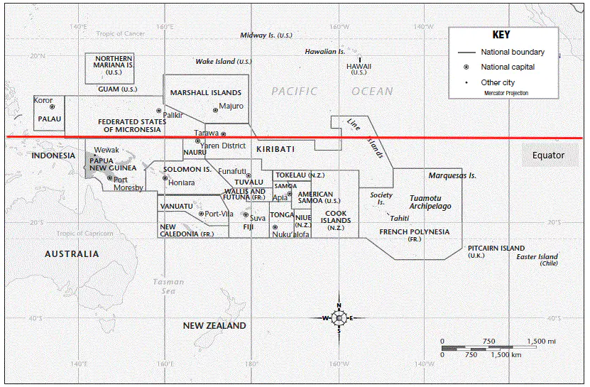
Climate can be determined based on the area's latitude on Earth. Study the map and select the climate type that would be at this latitude location.
Arid Climate
Humid Tropical Climate
Mediterranean Climate
You cannot determine Climate based on latitude
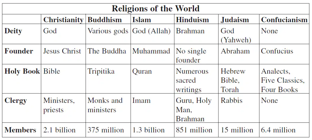
Which of the following is a characteristic that ALL of the religions listed in the chart have in common?
All religions have some sort of deity that is worshipped
All religions have a single recognizable founder that started the religion
All religions have a sacred text or holy book
All religions have a clergy that act as leaders
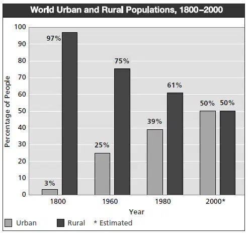
Which of the following is a true statement based upon the information in the bar graph?
It shows emigration loss around the world
it shows an increase in immigration around the world
it shows an increase in urbanization around the world
it shows how much population has increased around the world

What were the benefits of building the Panama Canal for trade and economic development throughout the world?
The canal’s construction reduced the time and expense it took to ship goods between New York and Panama
The canal's construction reduced time and expense it took to ship goods between San Francisco and Cape Horn
The canal's construction reduced the time and expense it took to ship goods between the Atlantic and Pacific Oceans
The canal's construction had no major benefits for trade or economics
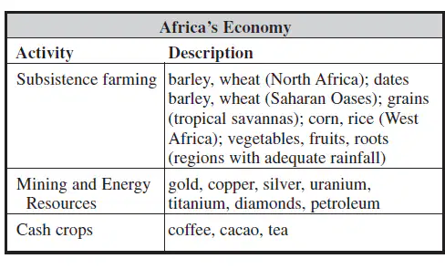
What are two examples of items that are grown in Africa that contribute to the continent's economic success?
coffee
gold
barley
silver
tea
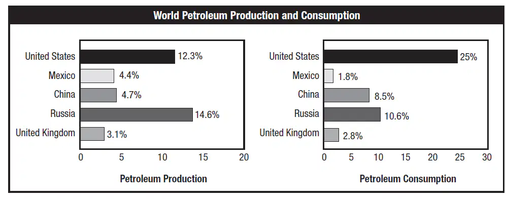
What conclusion can you make about the United States’ and China’s consumption of petroleum compared to its production of petroleum?
The US and China export their surplus of petroleum they produce to other countries
The US and China are able to make money selling petroleum to the United Kingdom
The US and China do not produce enough petroleum to meet their demand for it
The US and China do not produce enough petroleum to meet their demand for it
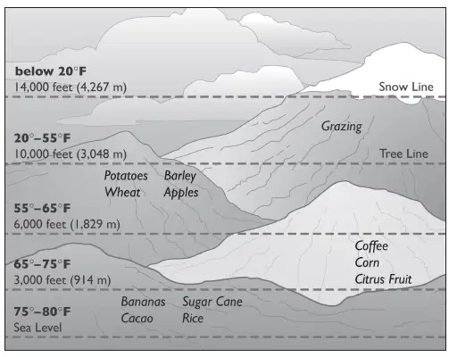
Which of the following is most likely to be true based on the diagram?
as elevation increases the temperature increases
as elevation increases the temperature decreases
below the tree line it is too cold for trees to grow
above the tree line it is always freezing temperatures
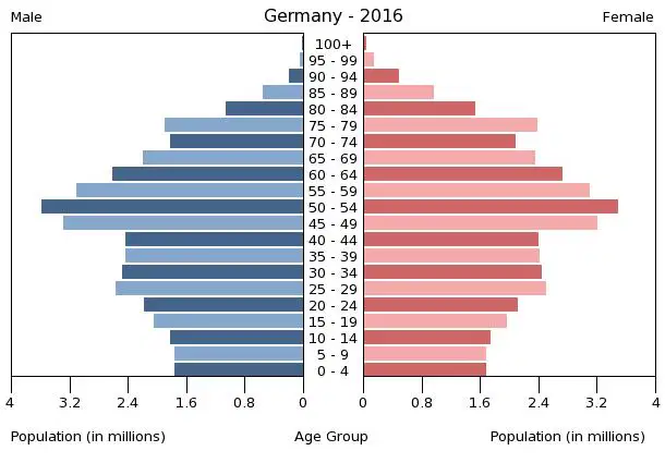
What conclusion can be drawn from this Population Pyramid chart, which compares the age and gender of people in Germany?
the population of Germany will likely increase in the future
the population of Germany is remaining the same over time
the population of Germany will likely decrease in the future
the population of Germany is 3.3 million total people
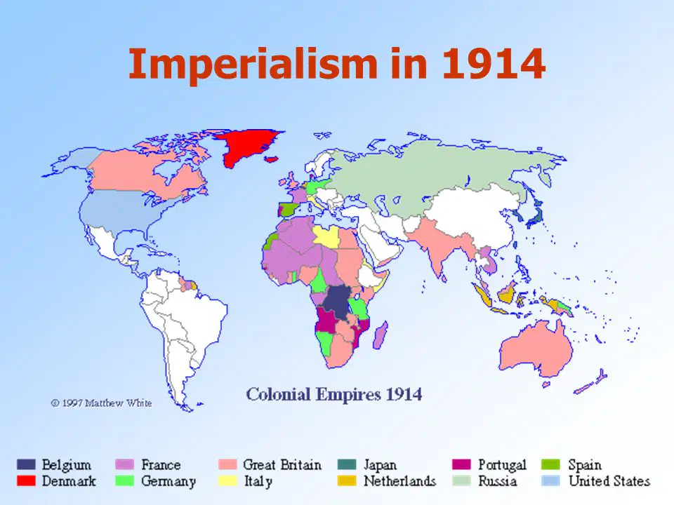
During the Age of Imperialism countries that had industrialized were conquering land around the world. Based on the map of Imperialism in 1914, which European country conquered the most land?
Japan
Great Britain
Russia
The Netherlands
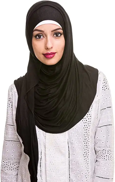
Based on the photograph, which cultural region would this women most likely represent?
Polynesian
Middle Eastern
Scandinavian
Latino
Aboriginal
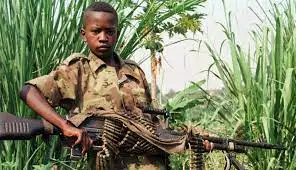
The photograph below shows a child soldier. Which continent with multiple conflicts has a history of using child soldiers to fight their wars?
Asia
North America
South America
Africa
Europe

Review the sketch of Lake Erie. Identify 2 environmental problems occurring in this sketch.
Which map would you choose to explain why Japan is vulnerable to earthquakes and tsunamis?
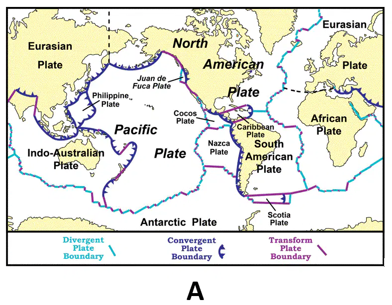
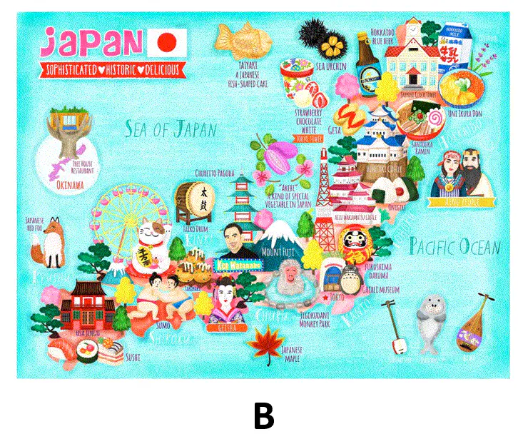

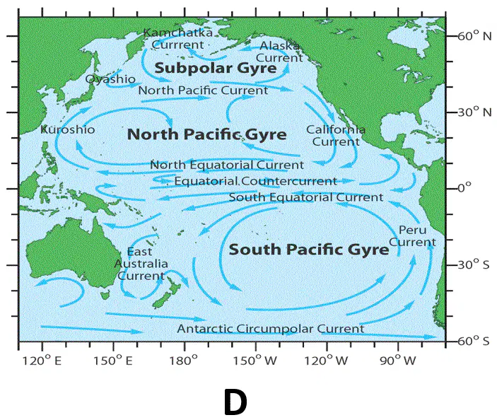
Using your answer from question #32. Explain why you selected that map to determine why Japan is vulnerable to earthquakes and tsunamis? Give specific evidence to support your answer, such as how the map you selected shows the answer to the question.

