wayground logo

Free Printable Worksheets

NEW

Font size

S
M
L
XL
Worksheets

Tropgraphic

Total questions: 22

Worksheet time: 37mins
Name
Class
Date
1.
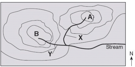
Which direction is the stream flowing?
a)
northward
b)
southward
c)
westward
d)
eastward
2.
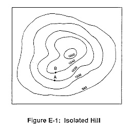
What is the highest elevation this hill could possibly have? (might not be labeled)
a)
1040
b)
1060
c)
1079
d)
1009
3.
What is the contour interval on this map?
a)
100
b)
10
c)
15
d)
20
4.
How many peaks are on the map? (hill tops)
a)
4
b)
3
c)
2
d)
1
5.
It is steep on a topographic map where __________.
a)
lines are closest together
b)
a river flows into a lake
c)
contours bend
d)
contours are far apart
6.
What feature is at the arrow?
a)
volcano
b)
mountain
c)
cliff
d)
river
7.
Determine the contour interval:
a)
5 m
b)
10 m
c)
15 m
d)
20 m
8.
What are the darker lines called?
a)
roads
b)
index contour
c)
contour interval
d)
waves
9.
What is the contour interval of the topographic map below?
a)
400 m
b)
200 m
c)
100 m
d)
80 m
10.
What do contour lines that are farther apart represent?
a)
waterfall
b)
steep area
c)
gentle slope
d)
river
11.
If we were in a plane, Path B --> C is about the same distance as path E --> N. But, which path is the easier walk? 
a)
B --> C is the easier walk
b)
E --> N is the easier walk
c)
B --> C and E --> N are the same walking distance
12.
What is the elevation of point B?
a)
800 ft
b)
850 ft
c)
900 ft
d)
1000 ft
13.
A satellite image of an area in Florida shows a river with slight bends along its length. A second satellite image taken of the same area 10 years later shows the same river with  a different course. What is the best explanation for the difference in the shape of the river's course between the two satellite images?
a)
Wind blew waves across the water surface, eroding away the bank on one side of the river until the river's course changed its shape
b)
Regular freezing and thawing of the river split the soil along the river banks, changing the shape of the river
c)
Water eroded the banks of the river and deposited the eroded soil on opposite banks, causing the river to form tighter bends
d)
Acid rain chemically weathered the banks along the river, forcing the river to wind back and forth
14.
This landform was probably caused by - 
a)
high tides.
b)
wind.
c)
human activity.
d)
running water.
15.

Which of the following best describes how mountains change over time?

a)

The elevation of the peaks will decrease due to erosion.

b)

The elevation of the peaks will increase due to weathering.

c)

The elevation of the peaks will increase due to deposition.

d)

Mountains stay the same, they never change.

16.

This is a satellite image of the Houston Ship Channel. Which point on this image will experience the most erosion?

a)

A

b)

B

c)

C

d)

D

17.

The image above shows the coastline of Sydney, Australia. What element is going to carry land away from the coast?

a)

Wind

b)

Water

c)

Ice

d)

Sand

18.

The image above shows sand dunes in a desert. What process is responsible for changing sand dunes in a desert?

a)

Glaciers

b)

Rain

c)

River

d)

Wind

19.
What is the highest elevation this hill could possibly have? (might not be labeled)
a)
1040
b)
1060
c)
1079
d)
1009
20.

Which events describe slow changes to earth's surface?

a)

volcanoes

b)

earthquakes

c)

landslides

d)

weathering

21.
What would be the most likely way this coastline would change over time?
a)
A fire could destroy the vegetation
b)
The waves could erode the beach
c)
The beach would grow due to deposition
d)
The beach will disappear due to plate tectonics
22.
Deltas forming at the mouths of rivers would be an example of...
a)
Weathering
b)
Erosion
c)
Deposition
d)
Preposition