wayground logo

Free Printable Worksheets

Font size

S
M
L
XL
Worksheets

Unit 3 Assessment Changing Earth

Total questions: 28

Worksheet time: 14mins
Name
Class
Date
1.
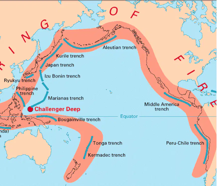
1) What is the purpose of the map below?
a)
To show the Kermadec Trench
b)
To show the Aleutian Trench
c)
To show the Equator
d)
To show the Ring of Fire
2.
2) What possible technique could scientists have used to create this map of the ocean ridges?
a)
observing from underwater vehicles
b)
monitoring sound waves
c)
surveying land levels
d)
comparing mountain ranges
3.
3) Which shows the elevation of an area using contour lines?
a)
mountains
b)
topographical maps
c)
cartographer
d)
faults
4.
4) Which type of map would best help a scientist study where earthquakes and volcanoes occur most often?
a)
Political map
b)
Topographic map
c)
Weather map
d)
Road map
5.
5) Which best describes how earthquakes and volcanoes shape the land?
a)
They break down the land.
b)
They build up the land.
c)
They can destroy things, but they can also build up the land.
d)
Only weathering and erosion can change the land.
6.
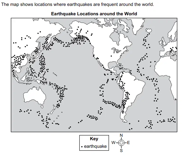
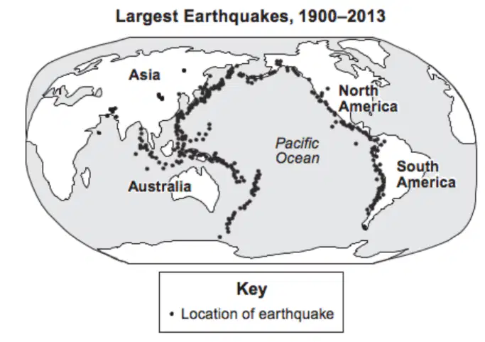
6. Based on the earthquake map below, which statement BEST describes the data in the map?
a)
Earthquakes occur in random locations.
b)
Most earthquakes occur in the Southern Hemisphere.
c)
The strongest earthquakes occur near the middle of oceans.
d)
Most earthquakes occur along boundaries between continents.
7.
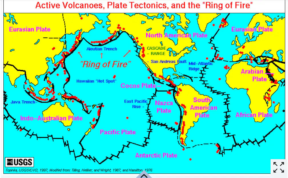
7) Look at the map of continental plates. What do you notice about the locations of earthquakes and volcanoes in relation to plate boundaries?
a)
Most earthquakes and volcanoes happen near plate boundaries.
b)
Earthquakes and volcanoes only happen in the middle of continents.
c)
There are no earthquakes or volcanoes near plate boundaries.
d)
Earthquakes and volcanoes happen randomly with no pattern.
8.
8) Why do earthquakes usually occur near plate boundaries?
a)
Earthquakes are caused by hot magma under the Earth's crust.
b)
Earthquakes occur randomly all over the world.
c)
Earthquakes happen due to the rotation of the Earth.
d)
Earthquakes result from the movement in Earth's techtonic plates.
9.
9) Plateaus, valleys, canyons, and mountains are all examples of ______________.
a)
highlands
b)
hydrosphere
c)
mantle areas
d)
landforms
10.
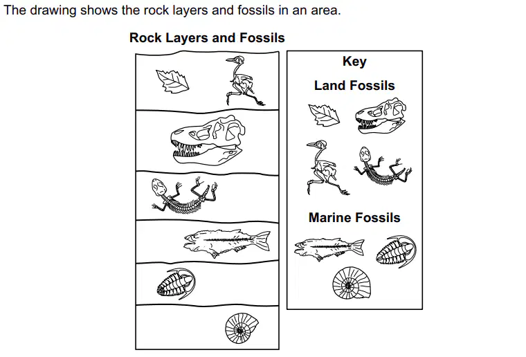
10) Which rock layer is the youngest?
a)
A
b)
B
c)
C
d)
D
11.
11) Use the drop-down menus to fill in the blanks to best describe this area and how it has changed over time: The oldest rock layer is the ______________ layer, and it has ______________ fossils. This means that a very long time ago, the area was __________________.
a)
top, land, dry land
b)
bottom, marine, underwater
12.
12) Which statement best explains why deeper rock layers often contain older fossils?
a)
Newer fossils are heavier and sink to the bottom layers.
b)
Older fossils disappear over time, leaving only the newer ones.
c)
Rock layers build up over time, covering older layers with newer ones.
d)
Wind and rain mix the layers, so age is not related to depth.
13.
13) Fossil evidence shows that a specific region once had many tropical plants but now has a dry, desert climate. What conclusion can be made?
a)
The land moved closer to the equator.
b)
The region experienced a major earthquake.
c)
The climate of the region changed over time.
d)
The plants evolved to survive in the desert.
14.

14) Select ALL of the correct agents that can cause weathering, erosion and deposition on Earth.
a)
water
b)
ice
c)
gravity
d)
wind
e)
sunlight
15.

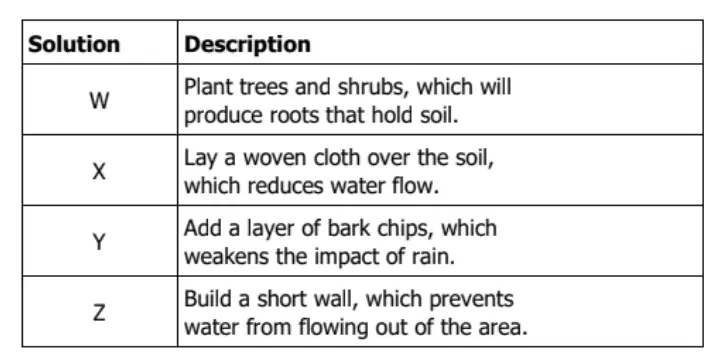
15) A city wants to protect a plot of land from water erosion to avoid runoff to nearby homes. The following table compares several solutions. The city wants to choose a solution that reduces water erosion and can be removed quickly. Which solution should the city choose?

a)
solution X
b)
solution Z
c)
solution Y
d)
solution W
16.

16) A scientist observes a canyon with a river flowing through it. What process most likely caused the canyon to form?

a)
Earthquakes splitting the land apart
b)
Wind blowing dust away over time
c)
Water eroding rock over millions of years
d)
Ice melting and refreezing in the ground
17.

17) A group of students measures the size of a rock before and after it was left in a river for one month. The rock became smaller over time. What process caused this change?

a)
Deposition
b)
Weathering
c)
Earthquakes
d)
Volcanic activity
18.

18) Sonia's teacher shows her class an example of weathering and erosion. How could Sonia’s teacher lead her class in an investigation that models weathering and erosion?

a)
Place several rocks into a freezer, take them out the next day, pour water on them, and observe.
b)
Place a large piece of ice on a layer of smaller rocks, place them in the refrigerator, and observe later.
c)
Put a rock with small cracks in it in water to soak, put the rock in the freezer, and observe it later.
d)
Put a large rock onto a table, chip off a small piece of the rock, put it in the refrigerator, and observe.
19.

19) Which of the following is a solution to reduce damage from earthquakes?

a)
Building houses on stilts
b)
Constructing buildings with flexible foundations
c)
Planting trees along hillsides
d)
Digging deep trenches near cities
20.

20) What is one way humans can reduce the impact of coastal erosion?
a)
Build stronger roads
b)
Construct seawalls or add vegetation along shorelines
c)
Increase fishing in coastal waters
d)
Allow ocean waves to carry sand away naturally
21.

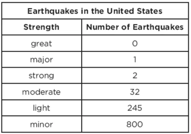
21) A scientist collected data on earthquakes in the United States for four years. She recorded her data in this chart. Which inference can she make from the data below?

a)
A minor earthquake is likely to happen somewhere in the United States every year.
b)
A great earthquake is likely to happen somewhere in the United States every year.
c)
A moderate earthquake is not likely to happen in the United States.
d)
A light earthquake can never happen in the United States.
22.

22) Fill in the blanks using the available answer choices. A ________________ is an instrument that detects and measures waves produced by earthquakes.
a)
seismograph
b)
digital sound level meter
23.

23) Based on the Earthquake map, select the BEST answer where is the next Earthquake most likely to occur?

a)
Near the equator
b)
Near the coastline
c)
Near a plate boundary
d)
Near a desert region
24.

24) A group of students are designing a model house that is safe in strong winds. Which house would be the safest?

a)
A house built out of mud.
b)
A house built out of toothpicks.
c)
A house built out of linking cubes.
d)
A house built out of craft sticks.
25.

25) What is the primary cause of volcanic eruptions?

a)

The rotation of the Earth

b)

The movement of tectonic plates

c)

The Earth's magnetic field

d)

The gravitational pull of the moon

26.

26) Why are fossils important for understanding Earth's history?

a)

They help in the formation of new rocks

b)

They are used to predict future earthquakes

c)

They are the main cause of volcanic eruptions

d)

They provide evidence of past life forms and environments

27.

27) A student makes a cross-section clay model to represent the internal structure of a volcano that leads to the formation of two rocks (X and Y). The student records the processes that affect the type of rock that is formed in a table. Which process(es) cause(s) the rock formed at location X to be different from the rock formed at location Y?

a)

1 only

b)

2 only

c)

1 and 3

d)

2 and 3

28.

28) The volcanoes on the Hawaiian Islands form due to which of the following?

a)

Divergent Boundary

b)

Hot Spot

c)

Subduction Boundary

d)

Transform Boundary