
 Worksheets
Physical Map of Africa
Total questions: 21
Worksheet time: 12mins
Name
Class
Date
1.

a)
Sudan
b)
Botswana
c)
Morocco
d)
Democratic Republic of Congo
2.

a)
Liberia
b)
Egypt
c)
Morocco
d)
Botswana
3.

a)
Madagascar
b)
Uganda
c)
Botswana
d)
Nigeria
4.

a)
Sudan
b)
Nigeria
c)
Democratic Republic of Congo
d)
Gabon
5.

a)
Kigali
b)
Tanzania
c)
Congo
d)
Kenya
6.

a)
Nigeria
b)
Mozambique
c)
Zambia
d)
South Africa
7.

What physical characteristic is #16?
a)
Sahara Desert
b)
Sahel
c)
Kalhari Desert
d)
Atlas Desert
8.

What physical characteristic is #11?
a)
Lake Victoria
b)
Lake Malawi
c)
Lake Erie
d)
Lake Tanganyika
9.

What physical characteristic is #12?
a)
Lake Victoria
b)
Lake Malawi
c)
Lake Nyasa
d)
Lake Tanganyika
10.

What is the circled physical characteristic?
a)
Congo River
b)
Niger River
c)
Sahara Desert
d)
Nile River
11.

What is the circled characteristic?
a)
Nile River
b)
Congo River
c)
Niger River
d)
Atlas Mountains
12.

Which landform is number 1?
a)
Kalahari Desert
b)
Atlas Mountains
c)
Namib Desert
d)
Sahara Desert
13.

The shaded area of the map represents which physical feature of Africa?
a)
Sahara
b)
Sahel
c)
Rainforest
d)
Kalahari Desert
14.

Semi-arid boundary of the desert
a)
Rainforest
b)
Sahel
c)
Sahara
d)
Atlas Mountains
15.
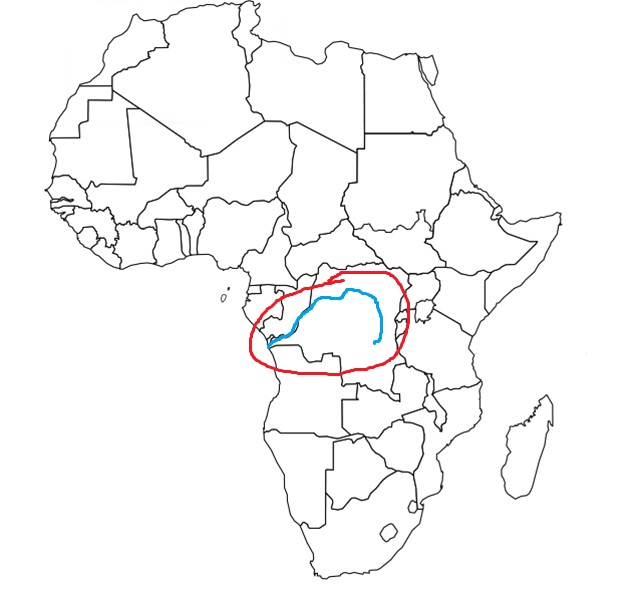
What landform is circled in the image?
a)
Zambezi River
b)
Nile River
c)
Niger River
d)
Congo River
16.

What is the following African Physical Feature?
a)
Mt. Kilimanjaro
b)
Congo River
c)
Atlas Mountains
d)
Niger River
17.

Which country is this?
a)
Djibouti
b)
South Sudan
c)
Uganda
d)
Rwanda
18.

Feature #3
a)
Atlantic Ocean
b)
Indian Ocean
c)
Southern Ocean
d)
Pacific Ocean
19.
Feature #6
a)
Atlantic Ocean
b)
Indian Ocean
c)
Southern Ocean
d)
Pacific Ocean
20.

What is the red area?
a)
Great Barrier Reef
b)
Great Rift Valley
c)
Great Salt Lake
d)
Dead Sea
21.

What is the following African Physical Feature?
a)
Mt. Kilimanjaro
b)
Congo River
c)
Atlas Mountains
d)
Niger River
100 %

