
 Worksheets
Chapter 4 Review
Total questions: 45
Worksheet time: 15mins
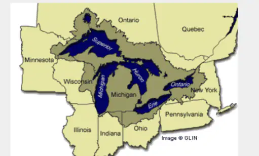
What are the Great Lakes?
A) A group of saltwater lakes
B) The world's largest group of freshwater lakes
C) A group of volcanic lakes
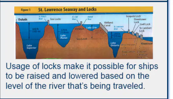
What is the significance of the St. Lawrence Seaway?
It is a natural river
It links the Great Lakes to the Atlantic Ocean
It is a mountain range
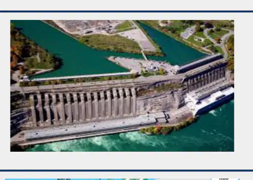
What is the largest hydroelectricity generating station in the world?
Hoover Dam
Sir Adam Beck Generating Station
Three Gorges Dam
Itaipu Dam
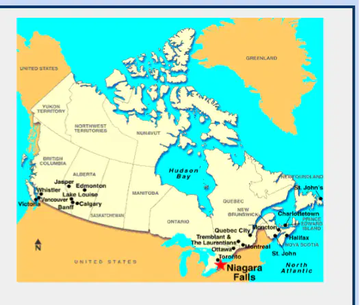
What is the U-shaped area surrounding the Hudson Bay called?
Appalachian Mountains
Canadian Shield
Rocky Mountains
Great Plains
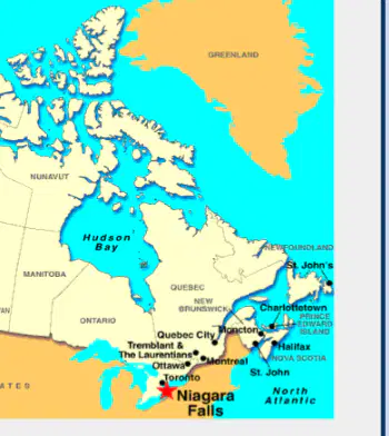
A bay is part of a large body of water that extends into a shoreline and is smaller than a ________.
gulf
lake
river
pond
The Canadian Shield is rich in which natural resources?
Forests and Timber
Minerals and Ores
Oil and Gas
Agricultural Land
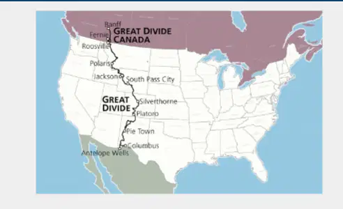
The Continental Divide is a natural boundary that determines which direction what flows?
Rivers
Mountains
Winds
Roads
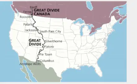
Rivers to the east of the Continental Divide flow in which direction?
North
South
East
West
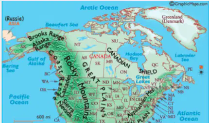
A cordillera is a:
type of mountain range
species of bird
kind of musical instrument
style of painting
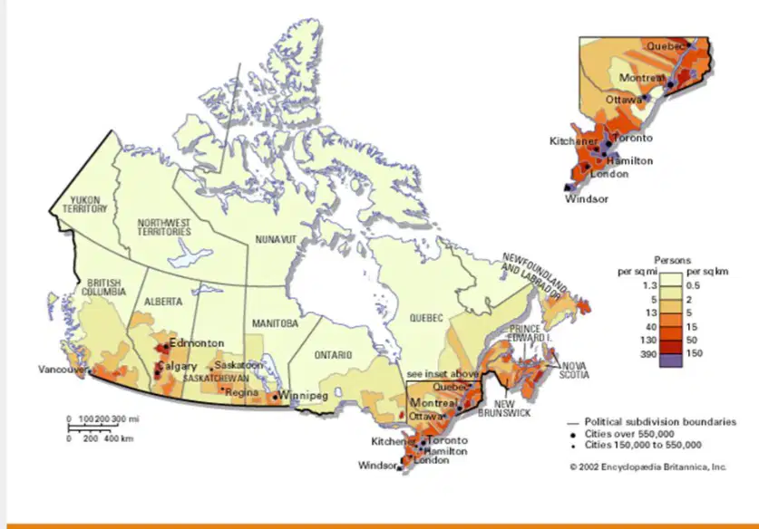
The map shows the population distribution in Canada. Which of the following best describes this distribution?
Evenly distributed across the country
Concentrated in urban areas
Sparse in the northern regions
Dense along the coastlines
Which is NOT one of the Great Lakes?
Huron
Michigan
Superior
Canada
Which of the Great Lakes is known for being the deepest?
Lake Erie
Lake Huron
Lake Michigan
Lake Superior
Where do most people in Canada live?
In rural areas where they can take advantage of the climate best for agriculture
In the southern regions, where temperatures are warmest
Near the Tundra, where the flat plateaus allow for easy travel
In the Canadian Cordillera, where the mountain views are best
The Geography of the Canadian Shield makes it best for
Agriculture
Forestry
Construction
Medicine
Why do you think Canada and the United States would have agreements about water pollution?
Both countries use water resources to generate most of their electricity.
Both countries depend on oceans and waterways for most economic activity.
The countries are facing severe water shortages.
The countries share a border and resources such as the Great Lakes.
Canada is bordered by this body of water on the west.
Atlantic Ocean
Pacific Ocean
Indian Ocean
Antarctic Ocean
Canada is bordered by this body of water on the east.
Atlantic Ocean
Pacific Ocean
Indian Ocean
Antarctic Ocean
The Great Lakes are located in
Canada
the United States
both Canada and the United States
neither Canada nor the United States
The main geographical feature of the Canadian Cordillera is
ocean views
tall mountains
flat plateaus
lush forests
Canada is surrounded by three oceans. How has this benefited trade?
It has made Canada a leader in exporting furs.
It has made Canada a leader in exporting fish.
It has made Canada a leader in exporting electronics.
In which region do most Canadians live?
Southern, near waterways
Northern, near Arctic
Western, near mountains
Why do the majority of Canadians live in the Southern part of the country?
To be near the Arctic Ocean
The climate is warmer in the South
The western region is mainly used for mining.

What is located at location A?
Quebec
Atlantic Ocean
Great Lakes
Hudson Bay

What is located at location B?
Quebec
Atlantic Ocean
Hudson Bay
Great Lakes

What is located at location D?
Quebec
Atlantic Ocean
Hudson Bay
Great Lakes

What is located at location D?
Atlantic Ocean
Canadian Shield
Great Lakes
Hudson Bay
There are many ____________ resources in the Canadian Shield.
mineral
agricultural
animal

Glacier
fishing and shipping industry
slow moving mass of ice
relating to the city
large rocky area
Canadian Shield
large rocky area in Eastern and Central Canada
fishing and shipping industry
large mass of ice
flat treeless arctic area

Which of the following letters indicates the correct location of Canada on the above map?
D
B
C
A

The Hudson Bay is surrounded by what numbers? 5 (pink) 6(light yellow)
9,7,5,8
1,8,4,5
3,5,7,4,
8,2,9,3

What Physical Feature in Canada goes through 9,1, and 8?
Hudson Bay
St. Lawrence River
Great Lakes
Rocky Mountains

The St. Lawrence River Can Be Found In What Province?
8
1
9
4
The Canadian Shield Surrounds this physical feature.
St. Lawrence River
Rocky Mountains
Hudson Bay
Great Lakes


