
 Worksheets
Nine Weeks Review
Total questions: 30
Worksheet time: 15mins
Which of the following questions might a geographer studying at a local level ask?
Which products does a country export?
What languages do people speak in South America?
How do people in a town or community live?
What features make up a physical region?
What is a map projection?
A. A particular map scale.
B. A way of representing a flat surface on a globe shape.
C. A way of projecting a map on a wall.
D. A way of representing the surface of a celestial sphere on a flat surface.
Which type of map would you use when you need to analyze geographic data represented on a map?
physical map
political map
special purpose map
general purpose map
Which type of map would you use when you need locate a certain city?
physical map
political map
special purpose map
general purpose map
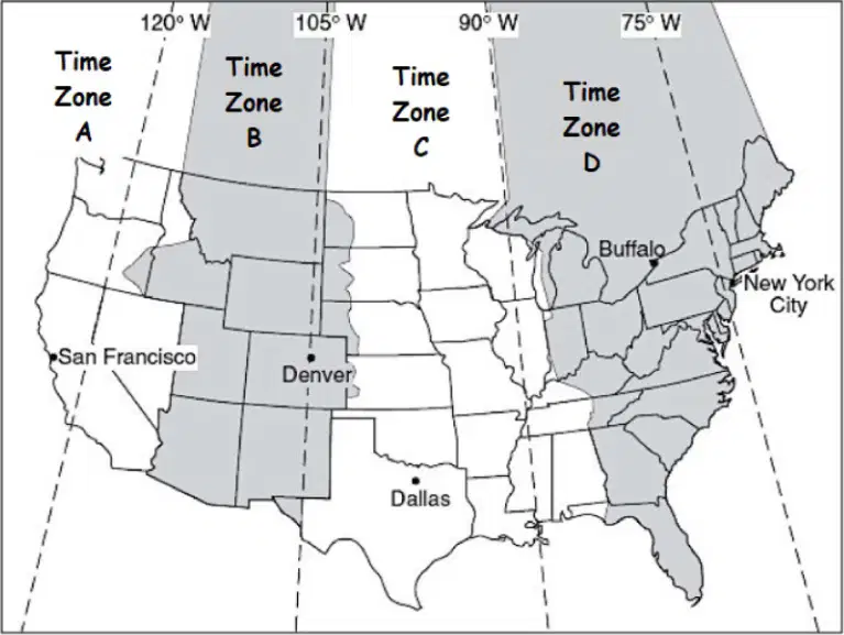
Look at the U.S. Time Zone Map above, what is the correct name of "Time Zone A"?
Pacific Standard Time
Central Standard Time
Mountain Standard Time
Eastern Standard Time
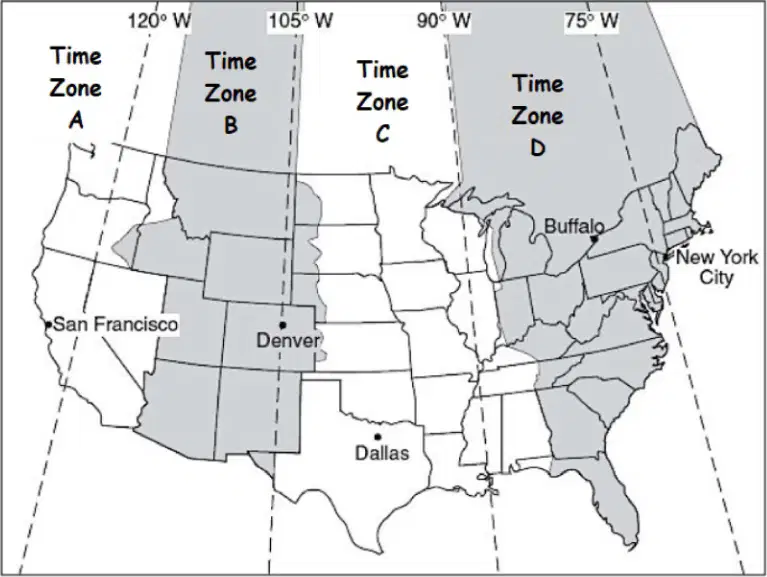
Look at the U.S. Time Zone Map above, what is the correct name of "Time Zone D"?
Pacific Standard Time
Central Standard Time
Mountain Standard Time
Eastern Standard Time
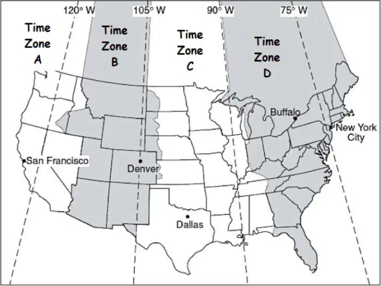
Look at the U.S. Time Zone Map above, what is the correct name of "Time Zone B"?
Pacific Standard Time
Central Standard Time
Mountain Standard Time
Eastern Standard Time
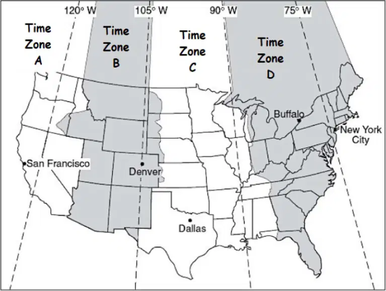
Look at the U.S. Time Zone Map above, what is the correct name of "Time Zone C"?
Pacific Standard Time
Central Standard Time
Mountain Standard Time
Eastern Standard Time
Imagine you’re in New Orleans, Louisiana, and your friend in Denver, Colorado, asked you to call her at 4:00 PM Mountain time. What time will it be in New Orleans when you call?
A. 3:00 PM
B. 4:00 PM
C. 5:00 PM
D. 6:00 PM
If it is 5:30 PM in Mississippi, what time is it in New York City?
4:30 PM
6:30 PM
2:30 PM
3:30 PM
Which of the following is not one of the five themes of geography?
Movement
Regions
Place
Environment
Your street address describes
absolute location
relative location
your environment
your society
Which of the following would a human geographer study?
soils and plants
maps and globes
weather and climate
economics and politics
Which theme of geography describes features that make a site unique?
A. Human-Environment Interaction
B. Movement
C. Place
D. Location
Which of the following is a scientific question that a geographer might ask?
Why do people from Mexico speak Spanish?
What caused the Rocky Mountains to form?
Why did the government of Afghanistan recently change?
All of the above
Geographers divide the world into regions
to compare different places.
because it is required by the national geography standards.
because regions are clearly defined.
to slow down worldwide trade.
The Rocky Mountains are a region defined by
human characteristics.
physical characteristics.
historical characteristics.
language & religious characteristics.
The statement that Japan is east of China refers to Japan’s
relative place.
region.
relative location.
absolute location.
Land, water, climate, plants, and animals are all part of an area’s
region
environment
climate
social science
A geographer who studies roads and routes is dealing with the theme of
Movement.
Human-Environment Interaction.
Physical Systems.
Location.
Using maps and other geographic representations is part of the essential element
Human-Environment Interaction.
Human Systems.
Places and Regions.
The World in Spatial Terms.
The theme of Human Systems includes the standard
How to apply geography to interpret the past.
How people create regions to interpret Earth’s complexity.
The processes, patterns, and functions of human settlement.
The physical processes that shape the patterns of Earth’s surface.
Measures distance north and south of the Equator, runs east to west, called parallels.
A. Latitude
B. Longitude
C. Equator
D. Meridian
Measures distance east and west of the Prime Meridian, run vertically from pole to pole, also called meridians.
A. Latitude
B. Longitude
C. Equator
D. Meridian
45. Southernmost point on the earth, 90 degrees south.
A. Equator
B. South Pole
C. Prime Meridian
D. Tropic of Capricorn
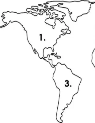
What is the name of the continent or ocean at location “3” on the map above?
Europe
Australia
South America
Africa
North America
Geography is the study of the Earth's landscapes, environments, and the relationships between people and their environments. What tools do geographers use?
Maps and globes
Telescopes and microscopes
Stethoscopes and thermometers
Paintbrushes and canvases
How is the work of geographers scientific?
By using qualitative methods only
By using quantitative methods only
By using both qualitative and quantitative methods
By not using any scientific methods
Geography can shape native cultures by influencing their lifestyle, food, and traditions. Which of the following is an example of this?
The Inuit people developing igloos in the Arctic region.
The Maasai people living in urban areas.
The Aborigines using modern technology in Australia.
The Native Americans adopting European architecture.
Identify the five themes of geography and give an example of each.
Location, Place, Human-Environment Interaction, Movement, Region
Latitude, Longitude, Equator, Prime Meridian, Tropics
Mountains, Rivers, Deserts, Forests, Oceans
Economy, Culture, Politics, History, Society

