
 Worksheets
Surveying Principles Quiz
Total questions: 95
Worksheet time: 48mins
Utilizes the principles for land, geologic and topographic surveying to control, locate and map underground and surface works related to mining operations.
Plane Surveying
Mine Surveying
Military Surveying
Route Survey
A periodical publication of astronomical data useful to a navigator.
Almanac
Record Book
Atlas
Encyclopedia
Average degree to which each point differs from the mean, also used as a measure of dispersion or spread of a distribution.
Accuracy
Range
Tolerance
Variance
Science of measurement and description of features which affect maritime navigation, marine construction, dredging, offshore wind farms, offshore oil exploration and drilling and related activities.
Topographic Survey
Photogrammetry Survey
Hydrographic Survey
Control Survey
Determines distance through linear and angular measurements of optical instruments.
Hydrographic Survey
Tacheometry
All The Above.
Telemetry
Determining positions of points; distance, direction, and elevation.
Zoning
Engineering
Surveying
Leveling
Branch of applied mathematics; determining area, length, directions.
Surveying
Engineering
Zoning
Pacing
Unpredictable and are often caused by factors beyond the control of the surveyor (e.g. environmental factors).
Human Errors
Random Errors
Human/personal Errors
Instrumental Errors
Science or art of making measurements; relative position of points.
Engineering
Surveying
Zoning
Monumenting
Determines distance through measurements of electromagnetic wave cycles and phases by a capable electronic instrument.
Electronic Distance Measurement
Tape Measure
Treats the Earth's surface as a plane and does not consider the effects of its curvature; used in small projects and yields fairly accurate results in areas less than 250 km².
Route Survey
Plane Surveying
Control Survey
None Of These
Due to limitations of the senses (e.g. carelessness of the observer, wrong parameters used).
Instrumental Errors
Systematic Errors
Personal Errors
Random Errors
Caused by variations in the phenomena of nature (e.g. magnetic declination, refraction, temperature, thermocline).
Systematic Errors
Random Errors
Natural Errors
Gross Errors
The measurement of dimensional relationships among points, lines, and physical features on or near the Earth's surface.
Engineering
Zoning
Surveying
Construction
For areas larger than 250 km², it is important to include the effects of the Earth's curvature in the calculations; leads to more complex solutions.
Route Survey
Geodetic Surveying
Cadastral Survey
Control Survey
Determines distance by recording the number of rotations the wheel makes while walking along a line. Relatively more accurate on flat terrain than elevated.
Construction Survey
Topographic Survey
Route Survey
Surveyor's Wheel
Caused by the surveying equipment, observation methods, and certain environmental factors (e.g. Not applying curvature and refraction constants, using an incorrect prism offset).
Systematic Errors
Gross Errors
Personal Errors
Natural Errors
Refers to the conformity of the measurements to its true value.
Error
Accuracy
Reliability
Residual
Establishment of the horizontal and vertical positions of arbitrary points.
Control Survey
Hydrographic Survey
Topographic Survey
Isolated Survey
Due to imperfections in the instruments (e.g. improper adjustments of equipment, not calibrated, broken parts).
Instrumental Errors
Environmental Errors
Personal Errors
Observational Errors
The weights are inversely proportional to the number of repetitions of angle measurements.
Standards for measuring temperature and pressure
Protocols for assessing light intensity and color
Regulations for calculating force and motion
Rules of Weights for angle
Measurements of relative positions of points; draw to scale.
Construction
Surveying
Engineering
Leveling
Refers to the conformity of repeated measurements of the same quantity.
Frequency
Sensitivity
Precision
Resolution
Art and science of determining angular and linear measurements.
Leveling
Zoning
Engineering
Surveying
An approximation of the true error of the sample.
Natural Errors
Residual Error
Random Errors
Most Probable Error
Utilizes the principle of aerial and terrestrial photogrammetry, in which measurements made on photographs are used to determine the positions of photographed objects.
Photogrammetric Survey
Control Survey
Route Survey
Topographic Survey
The difference between the measured value and the true value.
Error
Standard Deviation
Feedback
Resistance
The weights are directly proportional to the number of observations or measurements. The weights are inversely proportional to the square of the corresponding probable errors. The weights are inversely proportional to the total distance or length of a route.
Rules of Weights for distance and elevation
Guidelines for Calculating average speed and time
Principles of Weight distribution in structural engineering
Methods for Estimating total area and volume
Refers to those control, topographic and construction surveys necessary for the location and construction of lines of transportation or communication, such as highways, railroads, canals, transmission lines and pipelines.
Aerial Survey
Photogrammetric Survey
Property Survey
Route Survey
Used to estimate population standard deviation. It quantifies the variation in the means from multiple sets of measurements.
Accuracy
Standard Error of Mean
Variance
Most Probable Error
Performed to determine the length and direction of lot lines and to establish the position of these lines on the ground.
Control Survey
Photogrammetric Survey
Municipality Survey
Property Survey
Uses pace factor or the approximate length of one's step distance (pace) to determine distance. Very low accuracy.
Accuracy
Scaffolding
Pacing
Error
Made to secure data from which may be made a topographic map indicating the configuration of the terrain and the location of natural and human-made objects.
Route Survey
Topographic Survey
Control Survey
Construction Survey
The difference between the most probable value and the measured value or express the variation or deviation in the measurement.
Kinetic
Operating
Residual
Potential
Significant, unpredictable mistakes caused by human error (e.g. improperly levelling the surveying instrument).
Systematic Errors
Instrumental Errors
Gross Errors
Natural Errors
Used to establish the location and alignment of highways, bridges, buildings, pipes, and other man-made objects.
Title Survey
Route Survey
Control Survey
Construction Survey
A measure of the spread of a distribution of quantities. It quantifies the variation within a set of measurements. Also called the Root-Mean-Square Error.
Standard Work
Residual
Median
Standard Deviation
Measuring horizontal and vertical distances; angles between lines.
Leveling
Engineering
Surveying
Monumenting
Determines distance through using steel tapes or the Gunter's chain.
Taping/Chaining
Surveying
Pacing
Standard Deviation
Science and art of determining relative positions of points.
Engineering
Construction
Zoning
Surveying
The difference between the measured value and the true value.
Error
Feedback
Standard Deviation
Resistance
Refers to the conformity of repeated measurements of the same quantity.
Sensitivity
Resolution
Frequency
Precision
Significant, unpredictable mistakes caused by human error (e.g. improperly levelling the surveying instrument).
Natural Errors
Gross Errors
Instrumental Errors
Systematic Errors
Refers to those control, topographic and construction surveys necessary for the location and construction of lines of transportation or communication, such as highways, railroads, canals, transmission lines and pipelines.
Aerial Survey
Property Survey
Route Survey
Photogrammetric Survey
The weights are inversely proportional to the number of repetitions of angle measurements.
Protocols for assessing light intensity and color
Regulations for calculating force and motion
Rules of Weights for angle
Standards for measuring temperature and pressure
Used to establish the location and alignment of highways, bridges, buildings, pipes, and other man-made objects.
Construction Survey
Title Survey
Route Survey
Control Survey
Determines distance through linear and angular measurements of optical instruments.
Telemetry
Hydrographic Survey
Tacheometry
All The Above.
Science or art of making measurements; relative position of points.
Monumenting
Engineering
Zoning
Surveying
A periodical publication of astronomical data useful to a navigator.
Almanac
Record Book
Encyclopedia
Atlas
The difference between the most probable value and the measured value or express the variation or deviation in the measurement.
Operating
Potential
Kinetic
Residual
Due to limitations of the senses (e.g. carelessness of the observer, wrong parameters used).
Random Errors
Instrumental Errors
Systematic Errors
Personal Errors
Establishment of the horizontal and vertical positions of arbitrary points.
Control Survey
Hydrographic Survey
Isolated Survey
Topographic Survey
Utilizes the principles for land, geologic and topographic surveying to control, locate and map underground and surface works related to mining operations.
Route Survey
Mine Surveying
Plane Surveying
Military Surveying
Made to secure data from which may be made a topographic map indicating the configuration of the terrain and the location of natural and human-made objects.
Construction Survey
Route Survey
Topographic Survey
Control Survey
Measurements of relative positions of points; draw to scale.
Surveying
Leveling
Construction
Engineering
Used to estimate population standard deviation. It quantifies the variation in the means from multiple sets of measurements.
Variance
Accuracy
Standard Error of Mean
Most Probable Error
Due to imperfections in the instruments (e.g. improper adjustments of equipment, not calibrated, broken parts).
Observational Errors
Personal Errors
Instrumental Errors
Environmental Errors
Utilizes the principle of aerial and terrestrial photogrammetry, in which measurements made on photographs are used to determine the positions of photographed objects.
Photogrammetric Survey
Topographic Survey
Control Survey
Route Survey
Determines distance through measurements of electromagnetic wave cycles and phases by a capable electronic instrument.
Tape Measure
1/1
Electronic Distance Measurement
0/1
Performed to determine the length and direction of lot lines and to establish the position of these lines on the ground.
Control Survey
Municipality Survey
Photogrammetric Survey
Property Survey
Determines distance by recording the number of rotations the wheel makes while walking along a line. Relatively more accurate on flat terrain than elevated.
Surveyor's Wheel
Topographic Survey
Route Survey
Construction Survey
Measuring horizontal and vertical distances; angles between lines.
Monumenting
Leveling
Surveying
Engineering
Caused by variations in the phenomena of nature (e.g. magnetic declination, refraction, temperature, thermocline).
Systematic Errors
Gross Errors
Natural Errors
Random Errors
Science and art of determining relative positions of points.
Zoning
Surveying
Construction
Engineering
Science of measurement and description of features which affect maritime navigation, marine construction, dredging, offshore wind farms, offshore oil exploration and drilling and related activities.
Photogrammetry Survey
Hydrographic Survey
Topographic Survey
Control Survey
Treats the Earth's surface as a plane and does not consider the effects of its curvature; used in small projects and yields fairly accurate results in areas less than 250 km².
Plane Surveying
Control Survey
Route Survey
None Of These
The measurement of dimensional relationships among points, lines, and physical features on or near the Earth's surface.
Engineering
Zoning
Surveying
Construction
Determines distance through using steel tapes or the Gunter's chain.
Pacing
Standard Deviation
Taping/Chaining
Surveying
The weights are directly proportional to the number of observations or measurements. The weights are inversely proportional to the square of the corresponding probable errors. The weights are inversely proportional to the total distance or length of a route.
Rules of Weights for distance and elevation
Principles of Weight distribution in structural engineering
Guidelines for Calculating average speed and time
Methods for Estimating total area and volume
Average degree to which each point differs from the mean, also used as a measure of dispersion or spread of a distribution.
Accuracy
Variance
Range
Tolerance
Refers to the conformity of the measurements to its true value.
Reliability
Residual
Error
Accuracy
A measure of the spread of a distribution of quantities. It quantifies the variation within a set of measurements. Also called the Root-Mean-Square Error.
Residual
Standard Deviation
Median
Standard Work
Uses pace factor or the approximate length of one's step distance (pace) to determine distance. Very low accuracy
Scaffolding
Pacing
Accuracy
Error
Determining positions of points; distance, direction, and elevation.
Engineering
Leveling
Surveying
Zoning
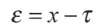
What is this formula for?
Most Probable Value
True Value
Error
Probable Value
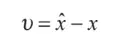
What is this formula for?
Residual
Variation
Variance
Deviation
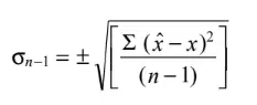
Formula for:
Variance
Deviation
Standard Deviation
Standard Variance

Formula for:
Root Mean Square
Variance
Weights
Sigma

Formula for:
Root Mean Square
Probable Error of Mean
Systematic Error
Standard Error of Mean
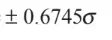
Formula for:
Confidence Interval
Confidence Limits
Most Probable Limit
Most Probable Error

Formula for:
Constant
Quantity
Weights
Limits

Formula for:
Weighted Mean
Summation of Weights
Weights
Mean
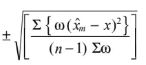
Formula for?
Standard deviation of an observation of limited weights
Standard deviation of an observation of weight
Standard deviation of an observation of unit weight
Standard error of the weighted mean
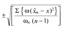
Formula for?
Standard deviation of an observation of limited weights
Standard deviation of an observation of weight
Standard deviation of an observation of unit weight
Standard error of the weighted mean
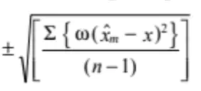
Formula for?
Standard deviation of an observation of limited weights
Standard deviation of an observation of weight
Standard deviation of an observation of unit weight
Standard error of the weighted mean
Theory of probability is applied to
Gross Errors
Systematic Errors
Random Errors
All of the above
Residual of a measured quantity is the
difference of the observed value from its most probable value.
value obtained by adding the most probable value to its true value.
remainder of the division of the true value by its most probable value.
product of the most probable value and the observed value.
If the standard deviation of a quantity is ± 1′′, the maximum error would be
2.39"
3.29"
2.93"
3.93"
If the standard deviation of an observation is ± 10 m, the most probable error would be
6.745 m
20 m
10 m
0.6745 m
The systematic errors
always positive
always negative
may be positive or negative
have same sign as the gross errors
Variance of a quantity is an indicator of
Precision
Accuracy
Randomness
Regular nature
In the case of a function y = f(x1,x2), the error in y is computed as
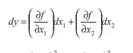
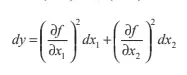
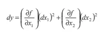
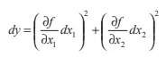
The adjusted value of an observed quantity may contain
Small gross errors
Small systematic errors
Small random errors
All of the above
One of the characteristics of random errors is that
small errors occur as frequently as the large errors.
plus errors occur more frequently than the negative errors.
small errors occur more frequently than the large errors.
large errors may occur more frequently.
If the standard error of each tape length used to measure a length is ± 0.01 m. the standard error in 4 tape lengths will be
0.01 m
0.02 m
0.04 m
0.016 m

