
Font size
 Worksheets
Unit 7 Practice Test
Total questions: 35
Worksheet time: 33mins
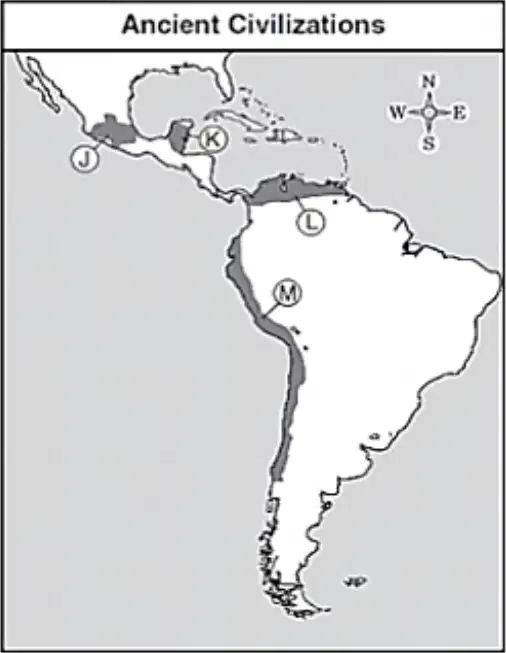
Explain the impact of geographic features and climate on the agricultural practices and settlement of the Maya, Aztec, and Incan civilizations. What letter shows the location of the Aztec Empire?
J
K
L
M
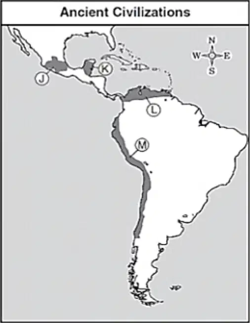
What letter shows the location of the Inca empire?
J
K
L
M
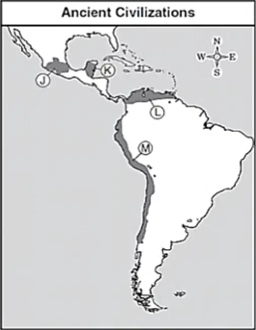
What major landform is at the area labeled M?
Appalachian Mountains
Andes Mountains
Alps Mountains
Incan Mountains
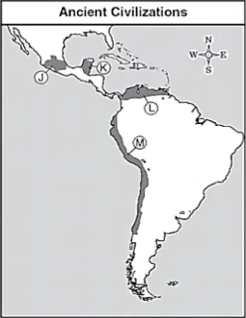
Which ocean borders the empire labeled M?
Pacific
Atlantic
Indian
Arctic
What was the farming technique employed by the Maya?
Plantation Farming
Slash and Burn
Terrace farming
Chinampas
What was the farming technique employed by the Aztecs?
Plantation farming
Slash and Burn farming
High-altitude farming
Chinampas farming
Which of the following best defines the term, chinampa?
A large plantation farm usually built around an oasis, typically used in dry climates due to lack of rainfall in the region.
A small, stationary, artificial island built on a freshwater lake for agricultural purposes, also called floating garden.
A traditional method of growing crops on steep hilly slopes by constructing successive levels of flat surfaces along the slope that resembles the steps of a ladder.
A method for harvesting food from the ocean through fishing techniques where floating platforms are used to hang several fishing hooks and divers retrieve fish and seaweed.
Which of the following cultures made use of the chinampa style of farming?
Maya
Iroquois
Aztec
Inca
Why did the culture listed in the previous question use chinampas?
Chinampas were needed in desert regions where water was scarce
Chinampas supported large populations by the clearing of large forested areas with fire
Chinampas helped them grow crops on sloped hillsides and feed the growing population
Chinampas allowed them to farm in marshy areas and overcome the lack of good farmland
As there wasn't a lot of flat land in the Inca Empire, what farming technique did they make use of?
Plantation farming
Slash and Burn farming
Terrace farming
Chinampas farming
Which civilization heavily depended on the llama for food, clothing, and transportation?
Inca
Aztec
Maya
Mississippian
How did the Andes Mountain range impact the agricultural practices of the Inca?
The large amounts of farmable land allowed for the utilization of plantation style farming.
The difficult terrain required the Inca to adapt their crops and techniques to ensure success.
The Andes Mountains led to the importation of most Incan resources.
The Inca utilized crop rotation to help create robust irrigation systems.
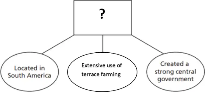
Which of the following best completes the graphic above?
Factors in the Growth of the Inca Empire
Reasons for the Rise of the Aztec Empire
Issues important in the Mayan Culture
Components of the Iroquois Civilization
Compared to the Aztec and Inca, the Maya
did not make use of trade networks
were never organized into a single Empire
never made use of scientific advancements
did not have successful agricultural practices
The slaves in Aztec society were mostly
merchants.
people of monotheistic religions.
prisoners of war.
those in debt.
Which of the following was NOT an accomplishment of the Mayan Empire?
An advanced calendar system
The development of iron tools
A hieroglyphic writing system
Advanced stone architecture
Which statement best describes the Mayan system of government?
A A barbaric tribal system that was based on the strongest warriors
B A matriarchy in which women ruled over the cities
C A collection of independent city-states with similar cultures.
D A democratic society that sent representatives once a year for a tribal council
In terms of religion, what did the Inca, Aztec, and Maya have in common?
all three were monotheistic
all three offered sacrifices to the gods
all three had a sacred text
all three adopted their religion from other cultures
Which culture had an advanced system of roads and bridges that helped connect the distant parts of a vast empire?
A Maya
B Aztec
C Inca
D Iroquois
The pyramids built by the Maya were used as
centers of government.
the bases for their temples.
defensive structures in times of war.
advanced medical centers.
Which of the following was a major use for the advanced calendar system developed by the Maya?
they used it to know when to mine for gold and silver
they used it to help determine the best time to plant crops
they needed a way to know when to have a change in leadership
they wanted to know when was the best time for long distance trade
The Inca leader Pachacuti
led a disorganized empire.
built a huge ancient empire.
developed a written language.
introduced monotheism to his people.
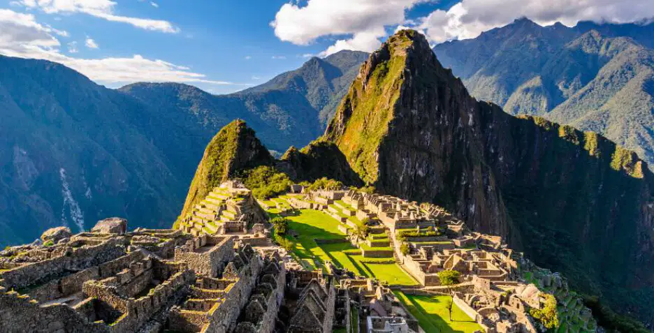
Which civilization built the city shown above?
Maya
Aztec
Iroquois
Inca
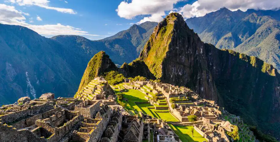
Which mountain range is the ancient city above located in?
Andes
Alps
Rockies
Himalayas
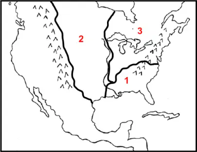
Which details best describe the area marked 2 on the map?
Rocky Mountains
Appalachian Mountains
Great Plains
Northeast Natives
Southeast Natives
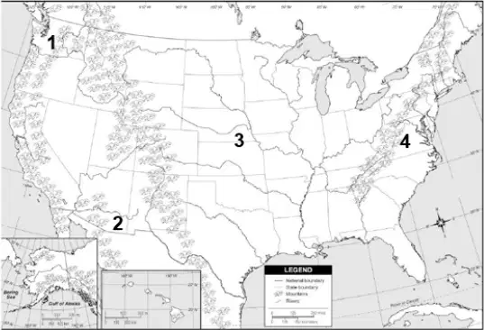
Explain the impact of geographic features on North American Indian cultures (i.e., Northeast, Southeast, and Plains), including: clothing, housing, and agriculture. Which area on the map was the location of the people who hunted buffalo and lived in teepees?
Southeast
Plains
Arctic
Eastern Woodlands
Which Native American culture group is described in the list below? - built longhouses out of wooden poles and bark that housed several families - several tribes joined together to form the Iroquois Confederacy - family lines were passed down through the mother
Southeast
Plains
Arctic
Eastern Woodlands

Use the images above to answer the following question: What is the most likely conclusion for the different materials used in the weapons of the Plains and Northeastern Natives?
Plains natives, being nomadic, had limited access to trade goods.
Native Americans utilized different resources based on their geographic location.
Native groups from different regions varied in their technological advancements.
Northeastern tribes hunted buffalo to extinction and transitioned to using deer.
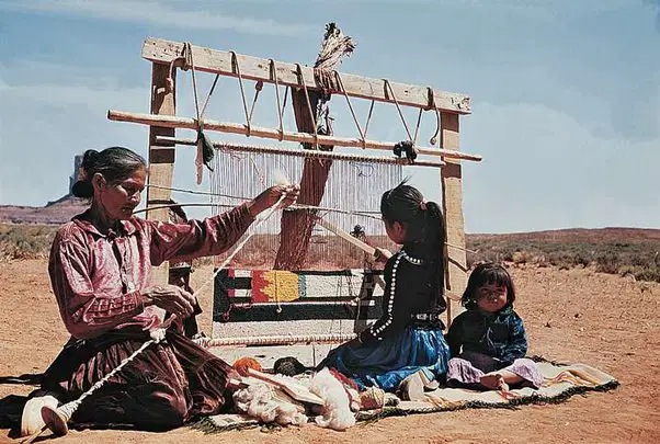
What do the sources above imply about the nature of gender roles in Native American societies? CHOOSE TWO.
Men and women did not have assigned tasks or roles in Native societies
Most native American groups existed in a matriarchal society
American Indians would often switch gender roles based on present needs.
Native women and men completed traditional gender roles.
Native men would be responsible for hunting and women responsible for making clothing
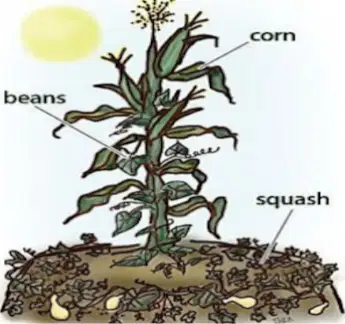
Use the image to answer the following: The image shown depicts which advanced farming technique utilized by Northeastern Natives?
Crop rotation
Terrace farming
Three Sisters method
Brick and notch planting

Use the map to answer the following: What does the image suggest about the economic networks that existed prior to the arrival of Europeans?
Tribes in North America had diverse trade networks that kept them economically connected.
Religious differences amongst tribes required regular wars to appease the gods.
Native Americans tribes remained relatively isolated from one another.
Groups in North America had major trade cities that served as centers for culture.
Match the following housing styles to the region in which they were used.

Far North

Eastern Woodlands

Great Plains

