
 Worksheets
Theory and Practice
Total questions: 100
Worksheet time: 50mins
If f is the focal length of the camera lens and θ is the angle of tilt, the distance of the plumb point from the principal point will be
a. f sin θ
b. f cos θ
c. f tan θ
d. f sec θ.
Pick up the incorrect statement from the following. High oblique photographs
a. may have tilt up to 30°
b. may include the image of the horizon
c. may not include the image of the horizon
d. none of these.
If two points differing by 1° of latitude and of the same longitude is 110 km apart on the earth, then two astronomical positions on the moon is abouta
a. 10 km
b. 25 km
c. 30 km
d. 30 km
The zenith is the point on the celestial sphere
a. east of observerb
b. west of observer
c. north of observer
d. south of observer
e. above the observer.
The longitudes of two places at latitude 60° N are 93° E and 97° W. Their departure is
a. 5100 nautical miles
b. 5700 nautical miles
c. 120 nautical miles
500 nautical miles
e. none of these.
Pick up the incorrect statement from the following :
a. In truly vertical photographs without relief angles are true at the plumb point
b. In tilted photographs without relief, angles are true at the iso-centre
c. In tilled photographs with relief, angles are true at the principal point.
d. none of these.
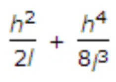
7. If h is the difference in level between end points separated by l, then the slope correction is __________ . The second term may be neglected if the value of h in a 20 m distance is less than
a. 1
2 m
b. 1 m
c. 2 m
d. 3 m
An ideal vertical curve to join two gradients, is
a.. circular
b. parabolic
c. elliptical
d. none of these.
The radius of curvature of the arc of the bubble tube is generally kept
a. 10 m
b. 25 m
c. 50 m
d. 100 m
If S is the length of a subchord and R is the radius of simple curve, the angle of deflection between its tangent and sub-chord, in minutes, is equal to
a. 573 S/R
b. 573 R/S
c. 171.9 S/R
d. 1718.9 R/S
e. 1718.9 S/R.
In chain surveying tie lines are primarily provided
a. to check the accuracy of the survey
b. to take offsets for detail survey
c. to avoid long offsets from chain lines
d. to increase the number of chain lines.
If f1 and f2 are the distances from the optical centre of a convex lens of focal length f to conjugate two points P1 and P2 respectively, the following relationship holds good
a. f = f1 + f2
1
b. f = 2 (f1 + f2)
1 1 1
f = f1 +f2
c. f
d. none of these.
The accuracy of measurement in chain surveying, does not depend upon
a. length of the offset
b. scale of the plotting
c. importance of the features
d. general layout of the chain lines.
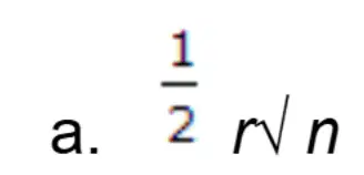
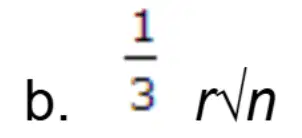
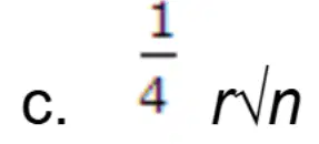
If a 30 m chain diverges through a perpendicular distance d from its correct alignment, the error in length, is


If R is the radius of the main curve, θ the angle of deflection, S the shift and L the length of the transition curve, then, total tangent length of the curve, is
a. (R - S) tan θ/2 - L/2
b. (R + S) tan θ/2 - L/2
c, (R + S) tan θ/2 + L/2
d. (R - S) tan θ/2 + L/2
e. (R - S) cos θ/2 + L/2
Two concave lenses of 60 cm focal length are cemented on either side of a convex lens of 15 cm focal length. The focal length of the combination is
a. 10 cm
b. 20 cm
c. 30 cm
d. 40 cm
The limiting length of an offset does not depend upon
a. accuracy of the work
b. method of setting out perpendiculars
c. scale of plotting
d. indefinite features to be surveyed.
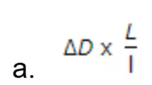
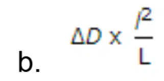
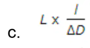
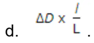
If L is the perimeter of a closed traverse, ΔD is the closing error in departure, the correction for the departure of a traverse side of length l, according to Bowditch rule, is
While viewing through a level telescope and moving the eye slightly, a relative movement occurs between the image of the levelling staff and the cross hairs. The instrument is
a. correctly focussed
b. not correctly focussed
c. said to have parallax
d. free from parallax.
Accuracy of 'fix' by two point problem, is
a. bad
b. good
c. not reliable
d. unique
The most reliable method of plotting a theodolite traverse, is
a. by consecutive co-ordinates of each station
b. by independent co-ordinates of each station
c. by plotting included angles and scaling off each traverse leg
d. by the tangent method of plotting.
Offsets are measured with an accuracy of 1 in 40. If the point on the paper from both sources of error (due to angular and measurement errors) is not to exceed 0.05 cm on a scale of 1 cm = 20 m, the maximum length of offset should be limited to
a. 14.14
b. 28.28 m
c. 200 m
d. none of these.
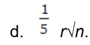
The probable error of the adjusted bearing at the middle is
The bearings of the lines AB and BC are 146° 30' and 68° 30'. The included angle ABC is
a. 102°
b. 78°
c. 45°
d. none of these.
The slope correction for a length of 30 m along a gradient of 1 in 20, is
a. 3.75 cm
b. 0.375 cm
c. 37.5 cm
d. 2.75 cm.
The main principle of surveying is to work
a. from part to the whole
b. from whole to the part
c. from higher level to the lower level
d. from lower level to higher level.
If the radius of a simple curve is R, the length of the chord for calculating offsets by the method of chords produced, should not exceed.
a. R/10
b. R/15
c. R/20
d. R/25.
The sensitiveness of a level tube decreases if
a. radius of curvature of its inner surface is increased
b. diameter of the tube is increased
c. length of the vapour bubble is increased
d. both viscosity and surface tension are increased.
ABCD is a regular parallelogram plot of land whose angle BAD is 60°. If the bearing of the line AB is 30°, the bearing of CD, is
a. 90°
b. 120°
c. 210°
d. 270°
Keeping the instrument height as 1.5 m, length of staff 4 m, the slope of the ground as 1 in 10, the sight on the down-slope, must be less than
a. 30 m
b. 25 m
c. 20 m
d. 15 m
An ideal transition curve is
a. cubic parabola
b. cubic spiral
c. clothoid spiral
d. true spiral.
If the angular measurements of a traverse are more precise than its linear measurements, balancing of the traverse, is done by
a. Bowditch's rule
b. Transit rule
c. Empirical rule
d. all of the above.
The latitude of a traverse leg is obtained by multiplying its length by
a. tangent of its reduced bearing
b. sign of its reduced bearing
c. cosine of its reduced bearing
d. cosecant of its reduced bearing.
A uniform slope was measured by the method of stepping. If the difference in level between two points is 1.8 m and the slope distance between them is 15 m, the error is approximately equal to
a. cumulative, + 0.11 m
b. compensating, ± 0.11 m
c. cumulative, - 0.11 m
d. none of these
For setting out a simple curve, using two theodolites.
a. offsets from tangents are required
b. offsets from chord produced are required
c. offsets from long chord are required
d. deflection angles from Rankine's formula are required
e. none of these
What is the primary responsibility of the LMS GE regarding the inspection of project control stations?
a) To verify the survey data of the project
b) To ensure that the project control stations are properly marked with monuments
c) To check the contractor’s report for compliance with regulations
d) To ensure the completion of the monument description book
In what scenario is a certification required for the project control stations and monuments?
a) When there are discrepancies in the project control map
b) When the primary control stations are not recovered or found on the ground
c) When the secondary control stations are verified
d) When the Political Boundary Survey has been approved
Who is responsible for issuing the Certificate of Acceptability and Endorsement Letter?
a) The contractor
b) The RTD for Lands
c) The Chief of Regional Surveys Division
d) The LMS GE
What is a prerequisite for conducting Political Boundary and Lot Survey in a numerical cadastral survey?
a) Approval of Main Project Control and Subsidiary Control
b) Certification from the contractor
c) Completion of the field notes
d) Verification of primary control
The Political Boundary Survey is checked against which of the following?
a) The Lot Description Book
b) The survey control points
c) The transmittal letter list
d) The Monument Description Book
What should be done if the Political Boundary Map is found to be defective?
a) Prepare a Pending Letter and inform the contractor
b) Approve the map without any changes
c) Immediately update the GNIS
d) Send the map for re-surveying
The Lot Survey returns must be checked for which of the following?
a) Field notes
b) Lot Description Book
c) Completeness of the computation sheets
d) All of the above
Which of the following instruments must be calibrated before use in a land survey?
a) Steel Tapes
b) Engineer’s Transit
c) GPS
d) All of the above
What document is required to register a surveying instrument?
a) Only the technical brochure
b) Invoice receipt from the vendor
c) Field notes
d) A certificate of calibration
Which instrument must have a magnification of not less than 30X for accurate measurement?
a) Electronic Distance Meters
b) Engineer’s Transit
c) Optical Theodolites
d) Digital Total Stations
The verification process for a Public Land Subdivision Survey involves checking compliance with which sections of the MLSP?
a) Sections 103 to 114
b) Sections 176 to 180
c) Sections 143 to 145
d) Sections 189 to 191
How should discrepancies between the field notes and the computation sheets be handled?
a) Inform the contractor to adjust the calculations
b) Prepare a Pending Letter for the contractor
c) Automatically approve the discrepancies
d) Recalculate the entire survey data
In a Graphical Cadastre, which of the following should be checked against the Transmittal?
a) The precision of the survey
b) The number of monuments recovered
c) The list of lots affected by deviations
d) The submitted documents' compliance with Section 176
When should the Geodetic Control Points be updated in the GNIS?
a) After every survey is conducted
b) Upon issuance of the Certificate of Acceptability
c) After the verification of the project control survey
d) After the final approval from the RTD for Lands
In what scenario must a GPS receiver be field-tested for survey accuracy?
a) Before calibration of the instrument
b) After the first use for the survey
c) Upon presentation of at least two units, one as a Base Receiver and the other as a Rover
d) When the survey data is suspected of being inaccurate
Where do you submit the survey returns for verification and approval?
a. Regional Survey Division
b. DENR
c. None of these
d. LMS
The point of zero declination on the ecliptic is at the:
a. Vernal equinox
b. Lower culmination of the sun
c. Upper culmination of the sun
d. Elongation of the Polaris
Geodetic engineers shall submit their ____________ filled out in the appropriate blanks and
signed and scaled by them.
a. Tracing plans
b. Duplicate plans
c. Original plans
d. None of the above
In WGS84 ellipsoid, the geocentric latitudes are equal at:
a. 45 degrees north
b. Equator
c. Poles
d. Both b and c
The width of easements for banks of arroyos, streams, esteros and rivers and the shore of seas and lakes throughout their entire length in forest areas.
a. 3 m.
b. 20 m.
c. 40 m.
d. 5 m.
Which of the following methods of contouring is most suitable for a hilly terrain?
a. Direct method
b. Square method
c. Cross-sections method
d. Tachometric method
The error due to eccentricity of inner and outer axes can be eliminated by_________.
a. reading both verniers and taking the mean of the two
b. taking both face observations and taking the mean of the two
c. double sighting
d. taking mean of several readings distributed over different portions of the graduated circle
Three-point problem can be solved by_______.
a. Tracing paper method
b. Bessels method
c. Lehman's method
d. all of the above
The great circle whose plane is perpendicular to the axis of rotation of the earth, is called
a. Equator
b. Terrestrial equator
c. 0° latitude
d. All the above
Agate cap is fitted with a _________.
a. cross staff
b. level
c. chain
d. prismatic compass
The latitude of a place was obtained by subtracting the zenith distance of a star from its declination, the observed star was between?
a. Horizon and equator
b. Equator and zenith
c. Zenith and pole
d. Pole and horizon
The station which is selected close to the main triangulation station, to avoid intervening obstruction, is not known as
a. Satellite station
b. Eccentric station
c. False station
d. Pivot station
23 cm × 23 cm photographs are taken from a flying height with a camera of focal length of 3600 m and 15.23 cm respectively. A parallax difference of 0.01 mm represents
a. 1 m
b. 2 m
c. 4 m
d. 8 m
The following sights are taken on "turning point"
a. foresight only
b. backsight only
c. foresight and backsight
d. foresight and intermediate sight
The horizontal angle between the true meridian and magnetic meridian at a place is called___________.
a. azimuth
b. declination
c. local attraction
d. magnetic bearing
The number of horizontal cross wires in a stadia diaphragm is _________.
a. one
b. two
c. three
d. four
The prime vertical passes through
a. The east point of the horizon
b. The west point of the horizon
c. The zenith point of the observer
d. All the above
Closed contours, with higher value inwards, represent a
a. depression
b. hillock
c. plain surface
d. none of the above
If the length of a chain is found to be short on testing, it can be adjusted by
a. straightening the links
b. removing one or more small circular rings
c. closing the joints of the rings if opened out
d. all of the above
Latitude of the observer's position is equal to altitude of
a. North pole
b. Pole star
c. Celestial pole
d. All the above
An instrument for ascertaining and compairing the relative magnitude and clusters of the stars.
a. Astrotransit
b. Astrograph
c. Astrometer
d. Astronomical Clock
The most important job of a supervisor of field survey is to:
a. Make himself liked
b. Get work done efficiently
c. Enforce discipline
d. Impress his men with his ability
A level surface which is used as reference for measuring vertical distances is called a:
a. Bench mark
b. Grade surface
c. Datum plane
d. Horizontal surface
The clockwise angle which a line makes with any reference-line, is called the:
a. Bearing
b. Declination
c. Deflection
d. Azimuth
The process of determining direction on a map relative to the earth’s surface is generally called:
a. Bearing
b. Direction
c. Geodetic
d. Orientation
In the manual for land survey procedure, establishment of geodetic control points by connecting to existing control, the connection shall be made to control on the same or higher order of accuracy. To achieve first order, the recommended number of observation is ______.
a. 6 or more
b. 4 or more
c. 5 or more
d. 3 or more
In tertiary control triangulation, the check on base not to exceed _____.
a. 1:10,000
b. 1:15,000
c. 1:50,000
d. 1:20,000
Advance survey shall be made only after a written authority is secured, upon recommendation of the __________ .
a. Chief of Cadastral
b. Chief Surveys Division
c. Regional Technical Director for Lands
d. Regional Executive Director
In primary control measurement by repetition, subtract the observed angle from the back azimuth of the proceeding line. If the difference is negative, add 360 degrees. the positive sum is the _________.
a. Forward solution
b. Back azimuth
c. Forward azimuth
d. Back solution
A traverse which closes to the point of its origin is known as ___________.
a. Circuit traverse
b. Hanging traverse
c. Loop traverse
d. Connection Traverse
All celestial bodies appear to revolve around the earth.
a. West to East
b. East to West
c. South to North
d. North to South
Regional Base Maps shall be drawn in the Transverse Locator projection on drafting film of uniform size 104 x 104 cm to a standard scale of _____________.
a. 1:600,000
b. 1:800,000
c. 1:500,000
d. 1:400,000
The resultant of the force of Earth’s attraction due to gravitation and the centrifugal force due to the rotation of the Earth.
a. Gravity
b. Centripetal force
c. Oscillation
d. Escape velocity
Any map showing boundaries and subdivisions of a tract of land determine by surveying
a. Planimetric
b. Flat
c. Principal point
d. None of the above
Several air photos mounted together to form a continous picture of a large area.
a. Strip photo
b. Mosaic
c. Photographic process
d. Photography
Which province has the largest estate area listed?
a. Laguna
b. Isabela
c. Occidental Mindoro
d. Cavite
Which system includes the transformation from WGS84 to PRS92?
a. Philippine Plane Coordinate System
b. Philippine Reference System of 1992 (PRS92)
c. Geographic Coordinate System
d. Azimuth Projection System
What is the standard size for Barangay Boundary and Index Maps (BBIM) and Municipal Boundary and Index Maps (MBIM)?
a. 50 x 50 cm
b. 54 x 54 cm
c. 60 x 60 cm
d. 48 x 48 cm
What scale is used for a maximum coordinate difference of 2400 to 3600?
a. 1:8000
b. 1:12000
c. 1:16000
d. 1:20000
At what maximum coordinate difference is the scale 1:100000 applied?
a. 24000 to 30000
b. 30000 to 36000
c. 18000 to 24000
d. 45000 to 60000
For coordinate differences of 36000 to 45000, what scale applies?
a. 1:120000
b. 1:150000
c. 1:200000
d. 1:250000
How is the north polar distance (P) determined for a celestial body with a south declination?
a. P = 90 − DP
b. P = 90 + DP
c. P = 90 − 2DP
d. P = 180 − DP
What formula is used to compute the hour angle of a circumpolar star at elongation?
a. cos t = (tan L⋅ sin D)
b. cos t = (tan L⋅ cot D)
c. cos t = (tan D ⋅ cot L)
d. cos t= (sin L ⋅ cot D)
Which scale corresponds to a maximum coordinate difference of 75000 to 90000?
a. 1:200000
b. 1:250000
c. 1:300000
d. 1:400000
For a coordinate difference of 12000 to 18000, which scale is used?
a. 1:40000
b. 1:60000
c. 1:80000
d. 1:100000
What scale is used when the maximum difference in coordinates is between 9000 and 12000?
a. 1:30000
b. 1:40000
c. 1:60000
d. 1:80000
Which factor determines the scale to be used in BBIM and MBIM maps?
a. Total area of the map
b. Maximum coordinate difference
c. Type of drafting material
d. Number of barangays or municipalities
At what coordinate difference range is the scale 1:250000 applied?
a. 60000 to 75000
b. 45000 to 60000
c. 30000 to 36000
d. 75000 to 90000
For a maximum coordinate difference of 45000 to 60000, what scale is used?
a. 1:200000
b. 1:250000
c. 1:300000
d. 1:150000
What is the scale for a maximum difference in coordinates of 12000 to 18000?
a. 1:40000
b. 1:60000
c. 1:80000
d. 1:100000

