
Font size
 Worksheets
Weather and Climate Unit 3 Test
Total questions: 46
Worksheet time: 39mins
A boundary in which two different air masses meet and do not mix, causing a change in the weather is:
the jet stream
the greenhouse effect
air pressure
a weather front
A large section of air with the same temperature and moisture level is called (a) .
a pressure gradient
an air mass
a hemisphere
a hurricane
The Sun strikes the Earth the most at the Equator and the least at the poles. This causes warm air to (a) from the equator and cold air to (b) at the poles.
Stay
leave
rise
sink
4. Temperature changes along the coast are usually less extreme than temperature changes farther inland. Which of the following statements best explains why?
It is much windier at the coast than farther inland.
The temperature of the land remains fairly constant.
It is much less humid at the coast than farther inland.
The temperature of the ocean remains fairly constant.
Which of the following data would be most useful for describing the climate of a specific area?
average weekly wind speeds for 1 month
daily relative humidity levels for 18 months
total annual precipitation amounts for 2 years
average high and low monthly temperatures for 20 years
In general, how does air move around the Earth? Pick the best answer.
from areas with deeper ocean to areas with shallower oceans
from areas of lower air pressure to areas of higher air pressure
from areas of higher temperature to areas of lower temperature
from areas of lower temperature to areas of higher temperature
The Gulf Stream is a current that brings warm ocean water from the south to the north. What type of heat transfer is this?
conduction
convection
radiation
water transfer
A cold front moving into an area can bring what type of weather?
warmer temperatures, clear and sunny skies
cooler temperatures, clear skies
warmer temperatures, clouds
cooler temperatures, clouds, and precipitation
In a particular region, a change in climate would likely have a greater effect on organisms than a change in weather would. Which of the following statements best explains why?
A change in climate causes more earthquakes than a change in weather does.
A change in climate causes clouds to form faster than a change in weather does.
A change in climate affects the number of daylight hours more than a change in weather does.
A change in climate affects an environment for a longer time than a change in weather does.
What is the initial source for global winds and convection in the atmosphere?
unequal heating of the Earth by the Sun
the rotation of Earth
the moon’s gravity
continental

Which of the following conditions produce the fog in the Grand Banks area?
dry air and fast ocean currents
cold air masses and high clouds
moist air and cold temperatures near the ocean surface
high air temperatures and high air pressure near the coast
Which of the following statements best describes the climate of an area rather than its weather conditions?
The summers are hot and humid.
The temperature at noon was 86°F.
Total rainfall on April 9 was 2 inches.
Strong winds are expected tomorrow evening.
High pressure is associated with what type of weather?
cloudy weather
cold weather
warm weather
fair/good weather
What happens to this water vapor?
The water vapor evaporates and escapes into space. New water is formed by precipitation.
The water vapor only rises for a very short time, then settles back into the ocean unnoticed.
The water vapor pushes clouds out of the way as it rises. This causes overcast conditions to clear.
The water vapor condenses as it cools, then it forms clouds. It returns to the Earth as precipitation.
Convection currents, resulting from uneven heating of the Earth's surface, cause (a) to form.
wind
fossils
mountains
volcanoes
When it is raining, water is returning to Earth during a water cycle stage called a.
condensation
deposition
precipitation
evaporation
Where does the initial source of energy come from that creates winds and thus surface currents?
the moon’s gravity
the sun
the rotation of the Earth
wind
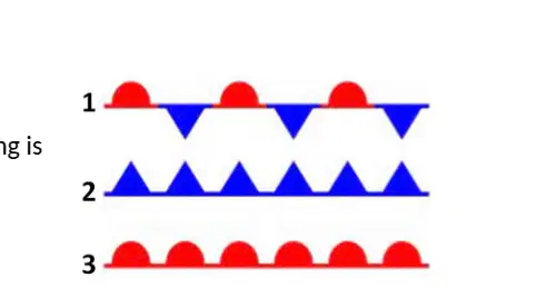
In the figure to the right, which of the following is the correct symbol for a stationary front?
1
2
3
Compared to the air at the poles, the air at the equator is warmer and
less dense, creating an area of high pressure as it rises
less dense, creating an area of low pressure as it rises
denser, creating an area of low pressure as it rises
denser, creating an area of high pressure as it rises
Solar energy heats the surface of the Earth, including the ground, rocks, and even roadways. As the temperature of these surfaces increases, heat energy is released back into the atmosphere, forming a pocket of warm air. As the warm air pocket rises, it is replaced by cooler air. This process is responsible for many of the weather patterns in our atmosphere, and is known as
convection
conduction
transpiration
evaporation
If a cool surface current flows along a coastline, what effect might it have on the climate in that area?
It will bring warmer temperatures in the summer and milder temperatures in the winters.
It will bring drier air and cause many droughts.
It will have no long term effect on climate in that area.
It will bring cooler temperatures in the summer and colder temperatures in the winters.
How can you tell which direction a front is moving on a weather map?
Look at the color of the front
Look for H’s or L’s
Look which way the triangles or circles are pointing
Look for rain clouds

The arrows in the diagram to the left show the circulation of air on a sunny day. The air circulation shown is caused by
both hot air and cool air sinking
hot air rising and cool air sinking
hot air sinking and cool air rising
both hot air and cool air rising

Once air mass A reaches location B, the weather conditions at location B will most likely become
warmer and drier
warmer and more humid
colder and more humid
colder and drier

Which factor has the greatest influence on the direction of the air mass track?
upper air currents
sea breezes
ocean currents
mountain barriers

The word LOW on the map refers to
air temperature
air pressure
relative humidity
cloud coverage
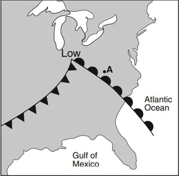
Precipitation is most likely occurring at A because it is located
on a cold ocean surface
near the cold front
on a warm land surface
near the warm front
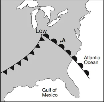
In which compass direction will the storm center (Low) most likely move over the next few days if it follows a typical storm track?
northeast
northwest
southeast
southwest

Use the diagram below to answer Questions 27 through 30. The fronts shown on the map are best described as
boundaries between different air masses
boundaries between different wind belts
areas experiencing clear skies with light winds
areas experiencing extremely warm air temperatures
What is convection?
31. How does convection on Earth cause the winds?
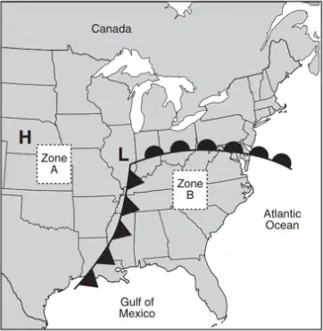
Use the diagram to answer questions a and b below:
a. Explain why the air mass centered over Zone A is colder and drier than the air mass centered over Zone (3 points)
b. Describe one weather condition that would likely occur along both fronts. (1 point)
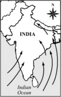
Use the diagram to answer the question.
In parts of India, the spring season is typically hot and dry. As spring changes to summer, strong winds blow moist air over the land. The map shows the direction of these strong summer winds.
Based on the map, identify the source of the moisture in the wind. (2 points)
Convection is a process of:
heat transfer through direct contact
heat transfer through fluid movement
heat transfer through electromagnetic waves
heat transfer through solid materials
How does convection on Earth cause the winds?
Convection on Earth causes winds by warm air rising and cold air sinking, creating a cycle.
Convection on Earth causes winds by cold air rising and warm air sinking, creating a cycle.
Convection on Earth causes winds by warm air sinking and cold air rising, creating a cycle.
Convection on Earth causes winds by warm air rising and warm air sinking, creating a cycle.

The air mass centered over Zone A is colder and drier than the air mass centered over Zone B because:
Zone A is located at a higher altitude.
Zone A is closer to the poles.
Zone A has less vegetation.
Zone A is influenced by ocean currents.

The source of the moisture in the wind is:
Indian Ocean
Deserts
Mountains
Forests
Continental air masses are more (a) ,
but Maritime air masses are more (b) .
Label the cold and warm front on the weather map.

Which statement best describes the climate of the two cities
Both locations are influenced by a warm current making them warm.
Hopedale is influenced by a cold ocean current making it colder and Stornoway is influenced by a warm ocean current making it warmer.
They have the same climate because they have the same latitude.
Stornoway is influenced by a cold ocean current making it colder and Hopedale is influenced by a warm ocean current making it warmer.

What is the name of the surface current that brings warmer temperatures to Europe?
EAC
Gulf Stream
Big Current
California Current

Major surface currents of the ocean are shown in the diagram.
Ocean currents affect weather patterns by -
regulating when tides occur in coastal areas
trapping heat at the equator to regulate the global climate
distributing heat from the uneven absorption of solar energy
increasing the rate of evaporation to transport water to areas experiencing droughts

Based on the map of ocean currents, which of the following statements is true? Choose 2 answers.
Warm ocean currents bring warm temperatures to the west coast of S. America.
Warm ocean currents bring warmer temperatures to the west coast of the U.S.
Cool ocean currents bring cooler temperatures to the west coast of the U.S.
Warm ocean currents bring cooler temperatures to the west coast of southern Africa.
Warm ocean currents bring warmer temperatures to the east coast of the U.S.

GLOBAL WINDS: Which winds are found between 30-60 degrees?
(a)
GLOBAL WINDS: Which winds are found between 0-30 degrees?
(a)
GLOBAL WINDS: Which winds are found between 60-90 degrees?
(a)

