
 Worksheets
Geography of Latin and South America Review
Total questions: 94
Worksheet time: 47mins

Guatemala
Mexico
Belize
Panama

Belize
Mexico
Guatemala
Costa Rica

Nicaragua
Honduras
El Salvador
Guatemala

Nicaragua
El Salvador
Panama
Costa Rica

Belize
Costa Rica
Panama
Mexico

Belize
El Salvador
Nicaragua
Panama


Which country is number 7?
Peru
Paraguay
Suriname
Colombia

Which country is number 10?
Colombia
Brazil
Paraguay
Chile

Which country is number 11?
Argentina
Paraguay
Uruguay
Bolivia

Which country is number 8?
Chile
Venezuela
Suriname
Brazil

Which country is number 2?
Suriname
Guyana
Colombia
Venezuela

Cuba
Dominican Republic
Belize
Jamaica

What is the following Latin American physical feature #6?
Lesser Antilles
Sierra Madres
Panama Canal
Greater Antilles


The Andes Mountains run along the
east coast of South America.
west coast of South America.
northern tip of South America.
southern tip of South America.
The Atacama Desert is located along the
Pacific coast of South America.
Pacific coast of Central America.
Atlantic coast of South America.
Atlantic coast of Central America.
The Panama Canal connects which two bodies of water?
the Caribbean Sea and the Atlantic Ocean
the Gulf of Mexico and the Atlantic Ocean
the Atlantic Ocean and the Pacific Ocean
the Arctic Ocean and the Pacific Ocean
The majority of the Amazon River is located within the borders of which South American country?
Argentina
Brazil
Chile
Colombia
The Sierra Madre Mountains are located in which of the following countries?
Brazil
Colombia
Cuba
Mexico

Name this physical feature
Amazon River
Maderia River
Parana River
Orinoco River

Name the physical feature.
Sierra Madre Occidental
Sierra Madre Oriental
Andes Mountains
Sierra Madre Del Sur

Name the physical feature.
Sonoran Desert
Mojave Desert
Baja Desert
Atacama Desert

Name the physical feature
Pacific Ocean
Atlantic Ocean
Indian Ocean
Arctic Ocean

Tacana Mountain
Baru Mountain
Sierra Madre Mountains
Andes Mountain

Name the physical feature.
Gulf of California
Gulf of Paria
Gulf of Mannar
Gulf of Mexico

Name the physical map
Red Sea
Caribbean Sea
Kara Sea
Barents Sea

Name the region of Latin America
Mexico
Central America
Caribbean Islands
South America
What is the cause of air pollution in Mexico City?
Using too many fossil fuels at one time
Burning of wood
Emissions from cars/truck
Not planting enough trees
What is the cause of deforestation in Brazil
logging
mining
ranching
all the above


This region of Latin America includes countries such as El Salvador, Costa Rica, Nicaragua, Guatemala, and Honduras among others
Central America
Mexico
the Caribbean
South America

Atacama Desert
Amazon Rainforest
Andes Mountains
Panama Canal

This mountain range goes up the west coast of South America...

What is the name of this mountain range?
Andes
Himalayas
Rocky
Sierra

The arrow on this map is pointing to what river?
Amazon
Nile
Thames
Volga

Which number represents the Pacific Ocean?
1
2
3
4

Which number on the map represents the Atlantic Ocean?
1
3
2
4

Which number on the map represents the Caribbean Sea?
2
3
5
8

Which region in Latin America is known for its dense rainforest and diverse wildlife?
Amazon Rainforest
Patagonia
Andes Mountains
Pampas
Mexico City's most pressing environmental issue is
mountain erosion.
dangerous air pollution.
erosion along the coastline.
cutting down of the rainforest.

What is the name of the longest mountain range in Latin America?
Andes
Alps
Rockies
Himalayas

Which body of water lies to the east of Latin America and is known for its turquoise blue color?
Caribbean Sea
Indian Ocean
Red Sea
Mediterranean Sea

Which country in Latin America is home to the Atacama Desert, one of the driest places on earth?
Peru
Chile
Argentina
Brazil


What is a rain forest
Dense forest that receives high amounts of rain each year
Forest that suffers from hurricanes most commonly
Forest that holds 6% of the Earth's population
What are the main sources of air pollution in Mexico City?
intense sunlight
the high altitude
factories and cars
cars that produce little or no air pollution
What are the two main reasons why Amazonian deforestation happens?
timber and cattle grazing
Which river flows through the Amazon Rainforest?
Nile River
Amazon River
Mississippi River

Latin America is divided into 3 regions. Select all that apply.
Mexico and Central America
North and South America
Caribbean
South America

2nd largest mountain range in the world along the west coast of South America!
Himalayan Mountains
Sierra Madre Mountains
Andes Mountains
Rocky Mountains

A ship canal 40 miles long across an Isthmus built by the United States
The Panama Canal
The Suez Canal
The Strait of Gibraltar
The Strait of Bosporus and Dardanelles
How has the Panama Canal affected world trade?
It has created a revolution in Panama
It has created an imbalance of world power
It has created tension between countries
Its has shortened trips and reduced costs
Which mountain range runs down the western edge of South America and serves as the eastern border of Chile?
the Andes
the Zagros
the Argentines
the Sangre de Christos
What is the best description of the location of the Andes Mountains?
The Andes Mountains run east-west in northern South America.
The Andes Mountains run east-west in Southern America
The Andes Mountains run north-south in western South America
The Andes Mountains run north-south in eastern South America.
This region of Latin America contains several islands including Puerto Rico, Jamaica, Hispaniola, and Cuba
Mexico
Central America
South America
the Caribbean
Which mountain range is location in Mexico?
Sierra Madres Mountains
Andes Mountains
Atacama Mountains
Sierra Nevada Mountains
Which ocean is on the western side of Mexico?
Pacific
Atlantic
Artic
Indian
Which country holds the largest percent of the Amazon Rainforest?
Cuba
Peru
Argentina
Brazil
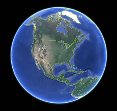
How many continents are there in the world?
6
7
10
1 Giant Continent
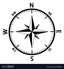
What is this direction finder called?
Briar Rose
Yellow Rose
Compass Rose
Rose Bowl
Match the correct label to the designated location
Pacific Ocean
Atlantic Ocean
Indian Ocean
Arctic Ocean
Match the correct label to the designated location
Atlantic Ocean
Pacific Ocean
Indian Ocean
Arctic Ocean
Match the correct label to the designated location
Caribbean Sea
Gulf of Mexico
Bering Strait
Lake Maracaibo
Match the correct label to the designated location
Gulf of Mexico
Caribbean Sea
Gulf of California
Atlantic Ocean
Match the correct label to the designated location
Sierra Madre Oriental
Sierra Madre Occidental
Andes Mountains
Guiana Highlands
Match the correct label to the designated location
Sierra Madre Occidental
Sierra Madre Oriental
Andes Mountains
Guiana Highlands
Match the correct label to the designated location
Andes Mountains
Guiana Highlands
Sierra Madre Occidental
Sierra Madre Oriental
Match the correct label to the designated location
Yucatan Peninsula
Plateau of Mexico
Patagonia
Gran Chaco
Match the correct label to the designated location
Atacama Desert
Pampas
Gran Chaco
Guiana Highlands

Which country is shaded on the map?

Which country is shaded on the map?

Which country is shaded on the map?

Which country is shaded on the map?

Which country is shaded on the map?

Which country is shaded on the map?

Which country is shaded on the map?

Which country is shaded on the map?

Which country is shaded on the map?

