
 Worksheets
South America Countries and Features
Total questions: 27
Worksheet time: 28mins

Look at the map of South America and match the countries with the correct number on the map.
6
Brazil
7
Uruguay
8
Falkland Islands
9
Argentina
10
Chile

What is the equator? (Standard SS6G1) SWW-1
a trench that splits the Earth into two hemispheres
an imaginary line that runs from north to south
an imaginary line that runs from east to west
an imaginary line that runs from west to north

Located in Chile, its one of the driest places on Earth!
Sahara Desert
Atacama Desert
Gobi Desert
Kalahari Desert
An imaginary line that lies halfway between the Northern and Southern Hemisphere, at 0 degrees LATITUDE
prime meridian
latitude
equator
longitude

Cuba and Jamaica are examples of __________________ islands.
Hawaiian Islands
Eastern Islands
Caribbean Islands
Southern Islands
The Amazon River in South America is an example of a....?
Human Geographic Characteristic
Physical Geographic Characteristic


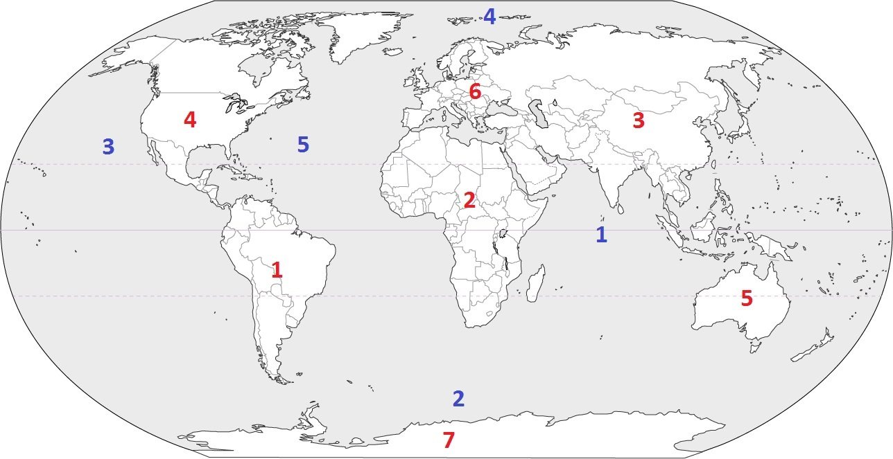
In the photo, number 1 is....
United States
Mexico
Brazil
Chile

Yellow is....
North America
South America
Europe
Australia
Africa

What physical feature is pictured here?
Caribbean Sea
Panama Canal
Atlantic Ocean
Amazon River

Geography is the study of what?
the universe and its features
the earth and its features
the state and its features
the continent and its features
Climate
the amount of rain received in a year
weather patterns over a long period of time
the average temperature and rain fall for a year
the current temperature outside
What mountain range runs the length of South America? (Standard SS6G1a) SWW-4
The Rocky Mountains
The Andes Mountains
The South American Mountains
The Central American Mountains

Latin America is divided into 3 regions. Select all that apply.
Mexico and Central America
North and South America
Caribbean
South America
Most of the Amazon Rainforest is located in what country? (Standard SS6G1a) SWW-4
Peru
Venezuela
Colombia
Brazil

Which is the Pacific Ocean?
1
2
3
4

What type of map is shown above?
thematic map
mental map
political map
physical map

2nd largest mountain range in the world along the west coast of South America!
Himalayan Mountains
Sierra Madre Mountains
Andes Mountains
Rocky Mountains

Use the following map and word bank to label the physical features of Latin America. (Standard SS6G1) SWW-3
F.
Amazon River
G.
Amazon Rainforest
H.
Pacific Ocean
I.
Atacama Desert
J.
Andes Mountains

Water that surrounds the West Indies, is a popular tourist area, and is a major trade route in Latin America.
Panama Canal
Caribbean Sea
Gulf of Mexico
Pacific Ocean
This region of Latin America contains several islands including Puerto Rico, Jamaica, Hispaniola, and Cuba
Mexico
Central America
South America
the Caribbean

Select all the options that make up Human Features
Culture
Economics
Government
History
Storms
Earth has SEVEN great bodies of land. They are called _____
global grids
hemispheres
continents
equator
The __________ was built in 1914 to encourage trade.
Amazon Rainforest
Andes Mountains
Sierra Madre Mountains
Panama Canal

Which continent does not have a permanent settlement of people?
Australia
Antarctica
Africa
The Middle East

