
 Worksheets
Simple Map
Total questions: 27
Worksheet time: 43mins
Name
Class
Date
1.
What IS NOT a part of most maps?
a)
Compass Rose
b)
Title
c)
Symbols/Key
d)
People
2.
Imaginary lines that circle the earth parallel to the equator are called this.
a)
longitude
b)
meridians
c)
latitude
d)
international dateline
3.
The 0 degree line of longitude that divides the Eastern and Western Hemispheres.
a)
Prime Meridian
b)
meridian
c)
equator
d)
parallel
4.
What is a map scale?
a)
a tool to measure distance
b)
a tool to tell direction
c)
a tool to start a fire
d)
a tool to build a house
5.
Where would you find the symbol that indicates which city on the map is the capital city?
a)
map scale
b)
map legend
c)
map elevation
d)
map title
6.
Tells the subject of the map
a)
map key
b)
map scale
c)
map title
7.
The 0 degree latitude line that divides the Northern and Southern Hemispheres.
a)
Prime Meridian
b)
time zone
c)
equator
d)
International Dateline
8.
A map showing boundaries of countries is what type of map?
a)
Political
b)
Physical
c)
Thematic
d)
Nothing
9.
Why is it necessary to have a map scale?
a)
mapmakers make things too big
b)
mapmakers make things too small
c)
mapmakers must make things smaller than they really are
d)
mapmakers distort everything
10.

What is this object known as?
a)
map symbol
b)
map key
c)
map scale
d)
compass rose
11.
A map showing cities, capitals, and states is which type of map?
a)
Political
b)
Physical
c)
Thematic
d)
Nothing
12.
A map showing mountains, rivers, oceans, elevation is what type of map?
a)
Political
b)
Physical
c)
Thematic
d)
Nothing
13.
A map showing bodies of water, lakes, and islands is what type of map?
a)
Political
b)
Physical
c)
Thematic
d)
Nothing
14.

What type pf map is this?
a)
Political Map
b)
Physical Map
c)
Natural Resource Map
d)
Population Density Map
15.

What kind of map is this?
a)
weather
b)
product
c)
physical
d)
political
16.
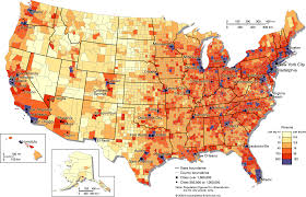
Identify this map.
a)
Population density map
b)
Zoning map
c)
Road map
d)
Physical map
17.

Identify this map
a)
Physical Map
b)
Climate Map
c)
Road Map
18.

What is the name of this line at 0 degrees latitude?
a)
Prime Meridian
b)
Equator
c)
North Pole
d)
South Pole
19.

What is the name of the line at zero degrees longitude?
a)
Equator
b)
Prime Meridian
c)
North Pole
d)
South Pole
20.

What is the approximate location of letter B?
a)
80oN, 0o
b)
0o, 80oW
c)
80oS, 0o
d)
0o, 80oE
21.
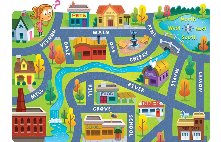
The bank is on what street?
a)
Main
b)
Maple
c)
Lemon
d)
River
22.
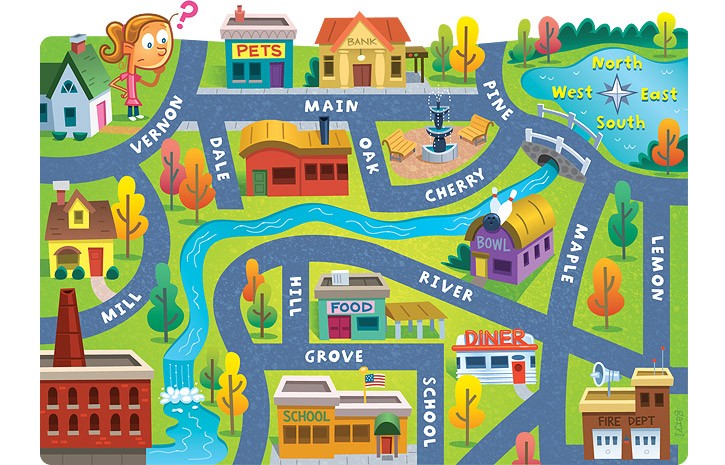
The school is ____ of the pet store.
a)
North
b)
South
c)
East
d)
West
23.
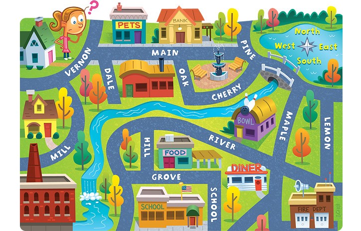
Lemon street runs _____________.
a)
East and West
b)
North and South
c)
South and West
d)
North and East
24.
What are the four cardinal direction?
a)
North, South, Windy, Sunny
b)
Never Eat Slimy Worms
c)
North, South, East, West
d)
South Never Eat West
25.
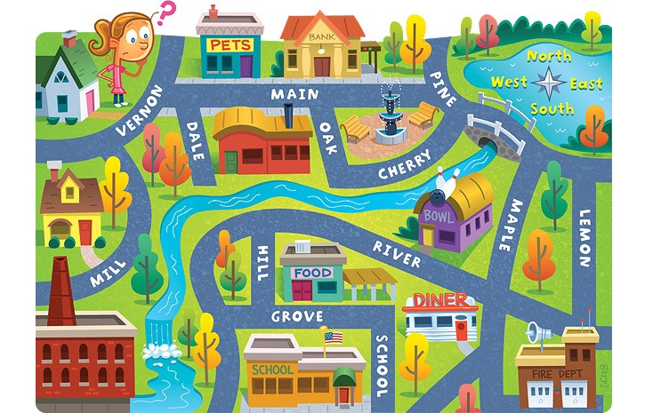
The fire dept. is ______ of the school.
a)
South
b)
East
c)
North
d)
West
26.
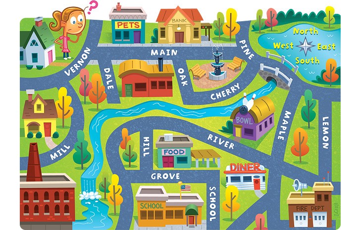
The bank is ____ of the pet store.
a)
East
b)
North
c)
West
d)
South
27.
A parallel of latitude north of the equator.
a)
Tropic of Casper
b)
Tropic of Candy
c)
Tropic of Cancer
d)
Tropic of Capricorn
100 %

