
Font size
 Worksheets
Ocean Currents and Climate
Total questions: 31
Worksheet time: 49mins
What drives the oceanic surface currents?
Coriolis Force
Prevailing winds
Hurricanes
Wind Gust
Ocean currents affect climatic temperatures on land.
True
False
If ocean currents and prevailing winds did not exist…
There would be no climates
The climates would be more extreme in terms of temperatures & precipitation amounts.
The climatic temperatures would differ from today’s climate but not the precipitation amounts.
The precipitations amounts would differ from today’s climate but not the climatic temperatures.
Match the following descriptions to El Nino or La Nina. Mark only one oval per row. Strong trade winds:
El Nino
La Nina
Match the following descriptions to El Nino or La Nina. Mark only one oval per row. Strong upwelling in the eastern Pacific Ocean:
El Nino
La Nina
Match the following descriptions to El Nino or La Nina. Mark only one oval per row. Bad for fishing:
El Nino
La Nina
Match the following descriptions to El Nino or La Nina. Mark only one oval per row. Wetter weather patterns on the west coast:
El Nino
La Nina
Where do hurricanes start their initial stages of formation?
On the equator in the Atlantic
Africa
Northern Atlantic Ocean
Gulf of Mexico
Caribbean Sea
In the northern hemisphere, hurricanes rotate _____ and in the southern hemisphere, hurricanes rotate _____. Mark only one oval.
Clockwise; counterclockwise
Counterclockwise; clockwise
clockwise; clockwise
counterclockwise; counterclockwise
The area of the hurricane with the strongest winds is the.
Eye
Rain bands
Eyewall
Convective clouds
The area of the hurricane with the weakest winds is the.
Eye
Rain bands
Eyewall
Convective clouds
Can hurricanes form tornadoes?
True
False
__________ cause the highest evaporation rate.
Fast winds
Slow winds
No wind
Match the following factors as needed or not needed to form hurricanes. Mark only one oval per row.
Warm water
Low evaporation rate
Coriolis effect
Why doesn’t California get hurricanes?
The winds aren’t blowing the correct direction.
The ocean current is cold.
There is too much evaporation in California.
The Coriolis force is too strong.
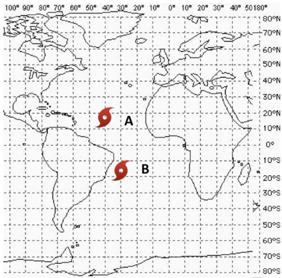
Where would you expect Hurricane A to be in 24 hours? (Refer to the map showing the positions of Hurricane A and B)
20°N 30°W
20°N 50°W
10°N 30°W
10°N 50°W
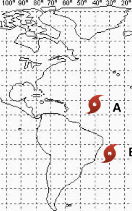
Where would you expect Hurricane B to be in 24 hours?
10°S 40°W
10°S 20°W
20°S 20°W
20°S 40°W
What causes the ocean surface temperatures to change between El
Nino to La Nina?
Cold water upwellings off the coast of Indonesia
Warm water upwellings off the coast of Indonesia
Strong trade winds blowing off the coast of South America
Weak trade winds blowing off the coast of South America
What is generally true about thermoclines?
Ocean temps are fairly constant above the thermocline
Ocean temps are fairly constant below the thermocline
Thermocline temperatures are constant around the world
There is no purpose to knowing what a thermocline is
What is a gyre?
A current of warm water along the coast
circulating water currents
A current of cold water in the open ccean
Where a cold and warm current collide with each other
What causes currents to change directions in different hemispheres?
Coriolis Effect
Butterfly Effect
Bernoulli Effect
Angle of Isolation
Which direction does the Coriolis Effect have on the Northern Hemisphere?
Warm water is pushed toward South America
Clockwise rotations
Counter-Clockwise rotations
Gyres made completely of cold water
Where do we find the strongest Upwellings?
Southern coast of continents
Northern coast of continents
Eastern coast of continents
Western coast of continents
Which current runs along the Eastern US coast and is responsible for the British
Isles' warmer winters?
Greenland Current
Canary Current
Labrador Current
Gulf Stream Current
What is a thermocline?
A rapid change in temperature with depth
A rapid change in temperature with latitude
A rapid change in salinity with depth
A rapid change in density with depth
Differing amounts of solar radiation across Earth's latitudes affect the ocean's...
salinity in the thermocline
density at the surface
temperature at the surface
density in the thermocline

The image is of a(n):
El Nino event
La Nina event
Non-El Nino (normal conditions)

The picture below is of a(n) ____ event.
Non-El Nino (Normal)
El Nino
La Nina
La Niña is characterized by ______________ of the Western Pacific Ocean.
a warming
a cooling
average temperatures

What is upwelling?
When cool, nutrient dense water rises to the surface
When warm, nutrient dense water rises to the surface
Temperature gradient of the ocean
When wind pushes warm water

What weather pattern is this a picture of?
La Nina
Normal weather
El Nino
La Tia

