
 Worksheets
Grade 10 Geography Mock Exam
Total questions: 143
Worksheet time: 2hrs 46mins
The amount of water vapor in the air is known as ___.
dew point
humidty
relative humidity
rain
Which one of the following is an accurate relative humidity reading?
32 degrees
24 mL
45%
15 NW
When the air is full of water and has a relative humidity of 100% it is said to be ___.
full
humid
saturated
warm
The condition of the atmosphere at a certain time and place is referred to as ___.
weather
climate
relative humidity
dew point
Which will hold more water, warm air or cold air?
Warm Air
Cold AIr
Dew is what?
Water that is pushed out by plants
Water that was a gas in the atmosphere, but when it cooled turned into liquid water touching a solid object
Water from the ground

colder air = higher humidty
warmer air = higher humidity


When less dense mountain air rises and is replaced by cooler, denser valley air
mountain breeze
land breeze
sea breeze
valley breeze

Movement of air from sea to land during the day when cooler air from above the water moves over the land, forcing the heated, less dense air above the land to rise
sea breeze
land breeze
valley breeze
mountain breeze

Air going towards the equator that is defected by the Coriolis effect. These are named because of their usefulness to merchant vessels
trade winds
prevailing westerlies
jet streams
squall lines
What characteristic do global winds and local winds share?
They are both wind.
They are both created by unequal heating of the Earth’s surface.
They both occur in small areas.
They both occur in small areas.
The Coriolis effect is the curving of wind across Earth. What causes winds to curve?
Earth's revolution
Earth's magnetic field
Earth's rotation
Earth's gravitational pull

The general pattern of winds around a high pressure area is clockwise, outward. The general pattern of winds around a low pressure area is counterclockwise, inward. Based on the information provided, which Texas city shown will most likely have winds from the north?
Port Arthur
Galveston
Corpus Christi
Brownsville

The general pattern of winds around a high pressure area is clockwise, outward. The general pattern of winds around a low pressure area is counterclockwise, inward. Based on the information provided, the winds in Monterrey, Mexico will be mainly from the -
north.
east.
south.
west.

The Jet Stream is a global pattern of atmospheric movement that influences patterns in local weather. Based on the information provided in the weather map, which city shown most recently experienced a drop in pressure and can also expect a rise in pressure over the next few days?
Atlanta
Cleveland
Los Angeles
Omaha

The general pattern of winds around a high pressure area is clockwise, outward. The general pattern of winds around a low pressure area is counterclockwise, inward. Based on the information provided, which city shown will most likely have winds from the south?
Rockford
Chicago
Kankakee
La Salle

The general pattern of winds around a high pressure area is clockwise, outward. The general pattern of winds around a low pressure area is counterclockwise, inward. Based on the information provided, The winds in Ann Arbor, Michigan will be mainly from the -
north.
east.
south.
west

The general pattern of winds around a high pressure area is clockwise, outward. The general pattern of winds around a low pressure area is counterclockwise, inward. Based on the information provided, which Texas city shown will most likely have winds from the east?
Abilene
Tyler
Houston
San Antonio
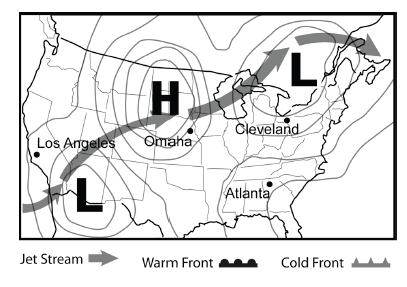
The Jet Stream is a global pattern of atmospheric movement that influences patterns in local weather. In general, one can expect clear skies with a high pressure area and cloudier conditions in areas of low pressure. Based on this information, and that provided in the weather map, which city shown most likely is currently experiencing clouds but will see clearer skies in the near future?
Atlanta
Cleveland
Omaha
Los Angeles
What is the primary force that drives the movement of wind in the Earth's atmosphere?
Coriolis effect
Pressure gradient force
Frictional force
Gravitational force
Which instrument is used to measure atmospheric pressure?
Anemometer
Barometer
Hygrometer
Thermometer
How does atmospheric pressure change with altitude?
It increases with altitude.
It decreases with altitude.
It remains constant.
It fluctuates randomly.

The dense subsiding air that flows toward the equator and is strongly defected to the west (coming from the east)
horse latitudes
prevailing westerlies
polar vortex
polar easterlies

Winds of upper and lower elevation air that flow toward the pole from 30 degrees are deflected toward the east (coming from the west)
prevailing westerlies
polar easterlies
trade winds
horse latitudes

What kind of air pressure does COLD air have?
High pressure
Low pressure

What kind of air pressure does WARM air have?
High pressure
Low pressure
In what direction (left or right) do winds curve in the Northern Hemisphere? Is this clockwise or counterclockwise?
Left; Clockwise
Right; Clockwise
Right; Counterclockwise
Left; Counterclockwise
Steady winds between the equator and 30o latitude north and south are known as the _______________.
doldrums
jet streams
easterlies
trade winds
The distinct wind patterns on Earth’s surface are created by ___________________ and by the Coriolis Effect.
Differences in heating
The ozone layer
magnetic fields
jet streams
What is the Coriolis Effect on wind patterns?
It allows them to go straight.
It causes them to turn in circles.
It causes them to turn slightly.
There is no Coriolis Effect.
What is the name for cooler air blowing from the land to the sea?
Sea Breeze
Land Breeze
Mountain Breeze
None of the Above
What is the name for cooler air blowing from the sea to land?
Sea Breeze
Land Breeze
Mountain Breeze
None of the Above
Global winds over the United States blow in which direction?
east to west
north to south
south to west
west to east

Is not a force but results from the difference in speed of winds relative to the ground as they move from one latitude to another when the winds appear to bend because of the movement of the earth.
doldrums
cyclones
horse latitudes
Coriolis Effect
What instrument is used to measure atmospheric pressure?
Barometer
Anemometer
Hygrometer
Thermometer
Which of the following best describes the Coriolis Effect?
It causes moving air and water to turn left in the southern hemisphere and right in the northern hemisphere.
It causes moving air and water to turn right in the southern hemisphere and left in the northern hemisphere.
It has no effect on moving air and water.
It causes moving air and water to move in a straight line.
What is the primary cause of wind?
Differences in air pressure
The rotation of the Earth
The presence of mountains
The distance from the equator

The general pattern of winds around a high pressure area is clockwise, outward. The general pattern of winds around a low pressure area is counterclockwise, inward. Based on the information provided, the winds in St Louis, Missouri will be mainly from the -
north.
east.
south.
west.

The Jet Stream is a global pattern of atmospheric movement that influences patterns in local weather. Based on the information provided in the weather map, which city shown most recently saw a rise in air pressure?
Baltimore
Jacksonville
Portland
Rapid City

The Jet Stream is a global pattern of atmospheric movement that influences patterns in local weather. Based on the information provided in the weather map, which city shown will most likely experience a drop in pressure over the next few days?
Baltimore
Jacksonville
Portland
Rapid City

The Jet Stream is a global pattern of atmospheric movement that influences patterns in local weather. Based on the information provided in the weather map, which city shown will likely see a drop in temperature in the near future?
Albany
Bismarck
Nashville
San Diego
Which of the following is a region where the atmospheric pressure at the surface of the planet is lower than that of surrounding locations; usually associated with stormy weather
Low Pressure Area
No Pressure Area
Mid Pressure Area
High Pressure Area
What is the measure of the force with which air molecules push on a surface?
Air Pressure
Jet Stream
Radiation
Trade Winds
What is a Hadley Cell?
a large-scale atmospheric convection cell in which air rises at the equator and sinks at medium latitudes, typically about 30 degrees North or South
A wind that blows from the land to the sea due to local temperature and pressure differences
Global winds that blow constantly from the same direction
Dominant winds of the mid-latitudes.
A region where the atmospheric pressure at the surface of the planet is greater than its surrounding environment, usually associated with dry weather
High Pressure Area
Low Pressure Area
Mid Pressure Area
No Pressure Area
Prevailing cold winds that blow from the east to the west near the North Pole and South Pole?
Polar Easterlies
Westerlies
Coriolis Effect
Prevailing Winds
What are prevailing winds that blow from east to west from 30 degrees latitude to the equator in both hemispheres?
Trade Winds
Land Breeze
Hadley Cell
Jet Stream
These winds move from the subtropical highs to the subpolar lows from west to east
Westerlies
Polar Easterlies
Jet Stream
Sea Breeze
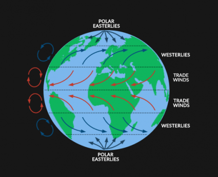
What is the Coriolis Effect?
the spread of something over a given area
the effect of Earth's rotation on the direction of winds and currents
winds in northern Indian ocean that blow from the southwest in the summer & from the northeast in winter
two layers of horizontal winds moving in opposite directions
What instrument is used to measure atmospheric pressure?
Barometer
Anemometer
Thermometer
Hygrometer
Which of the following best describes the Coriolis effect?
The deflection of moving objects due to Earth's rotation
The increase in wind speed with altitude
The decrease in atmospheric pressure with altitude
The change in temperature with latitude
What causes the trade winds to blow from east to west in the tropics?
Earth's rotation and the Coriolis effect
The presence of mountain ranges
The difference in temperature between the poles and the equator
The gravitational pull of the moon
Without the rotation of the planet there wouldn't be a spin of winds around the eye of the hurricane.
True
False
For a weather system to be called hurricane, a certain wind speed is needed.
True
False
Storming over land usually increases the power of the hurricane.
True.
False.
Hurricanes hit the US usually from the south-west.
True.
False.
A hurricane can form without warm moist air.
True.
False.
Gale force means low speed.
True.
False.
The eye of the hurricane is calm but its walls have the fastest spinning winds.
True.
False.
Florida is often hit by hurricanes.
True.
False.
Landfall means a storm system leaving land.
True.
False.
Swirling means spinning.
True.
False.
The word for heavy waves lapping out onto the land is sturgeon.
True.
False.
Catastrophic damage causes the complete destruction of all houses in an area (no walls remain standing).
True.
False.
For tropical storms or hurricanes to form a main ingredient is the existence of land masses that have different temperature, humidity and therefore different pressure.
True.
False.
Weather and climate both refer to atmospheric conditions.
True.
False.
The main rainforests are found in the following areas:
South America, Africa, South East Asia
South America, North America, Africa
South America, Africa, Europe
Europe, North America, Australia
Most tropical rainforests are located in a band around which line of latitude?
Tropic of cancer
Equator
Tropic of Capricorn
Arctic circle
Antarctic circle
Which of the following most accurately describes climatic conditions in the tropical rainforest?
Hot, usually over 27oC and very wet with over 2000mm of rainfall per year
Hot, usually over 27oC and very wet with over 4000mm of rainfall per year
Hot, usually over 37oC and very wet with over 2000mm of rainfall per year
What are the tallest trees in the rainforest known as?
Canopy
Emergents
Under canopy
True canopy
The canopy contains the most of the _____ in the rainforest.
Fungi
Air
Animals
Soil
Which of the following is the main reason for the high temperature in tropical rainforests?
A. Little cloud amount
B. Receive large amounts of solar radiation
C. Small heat loss at night
D. Vigorous photosynthesis of vegetation
Which rainforest layer has short bushes, trees, and ferns?
Forest floor
Understory
Canopy
Emergent layer
What percentage of all biodiversity (plants and animals) is found in rainforests?
5-10%
20-30%
40-50%
70-80%

Why do trees have lots of surface roots?
Shallow soil.
High rainfall.
Lack of light on the forest floor.
Insect protection
The rainforest is stratified - it has different layers.
The layers, in order from top to bottom, are...
Herb, shrub, sub-canopy, canopy, emergent
Emergent, canopy, sub-canopy, shrub, herb
Canopy, emergent, sub-canopy, herb, shrub
Canopy, emergent, sub-canopy, shrub, herb
The biggest store of nutrients in the rainforest is in the..
Soil
Litter
Biomass
The constant rainfall means that a lot of water infiltrates through tropical rainforest soils. As it moves through the soil, the water takes nutrients with it.
Name this process:
Runoff
Weathering
Leaching
Decomposition
Select the way(s) in which plants have adapted to the high levels of rainfall
Thick waxy leaves
A wide canopy
Drip tips
These plants climb tree trunks to reach the light:
Epiphytes
Mahogany
Lianas
King Fern
Many trees have buttress structures at their base. Why?
To prevent moss and algae growing over leaves
To reach deep into the soil to access groundwater
To keep the tall, slender trunks anchored upright
So that water runs off quickly

What type of plant in the above photo belongs to?
A. Epiphytes
B. Parasites
C. Stranglers
D. Flowers
Name the main characteristics of a hot desert
High daytime temperatures, low night time temperatures, low rainfall
High daytime temperatures, high night time temperatures, low rainfall
Low daytime temperatures, high night time temperatures, high rainfall.
Low daytime temperatures, low night time temperatures, high rainfall
Deserts are located in areas of...
High pressure
Low pressure
Most deserts are found between what degrees north and south of the equator?
10 to 30 degrees
20 to 40 degrees
20 to 35 degrees
0 to 20 degrees
A lack of cloud in deserts leads to extreme ................... temperature ranges
Diurnal
Annual
Mean
Perennial
Which of the following is not a characteristic of hot deserts
High humidity
Very hot during daytime
Very cold during night time
Warm, dry winds
What word describes being without moisture; extremely dry; parched
Barren
Aridity
Thirsty
Tropistic
A plant, which has adapted to survive within an environment with very little liquid water.
Cactus
Joshua Tree
Xylophone
Xerophyte
A thick fleshy plant which retains water well within it’s stem and have very small leaves.
Cactus
Prickly Pear
Succulent
Josua Tree
What is the driving force for plate tectonics?
gravity slab pull
the push of the mid-ocean ridge
the gravity of the Moon and Sun
mantle convection
If a divergent plate boundary is found within a continent,
a line of volcanoes forms.
a subduction zone forms.
the continent rifts apart.
none of these.
In the Hawaiian islands, the youngest volcano
is about to subduct into a deep-sea trench.
is above a hotspot.
is above a mid-oceanic ridge in the Pacific.
is topped by limestone.
. Plate tectonics theory says that
Earth’s geography has been the same for all geologic time.
Earth’s geography is continually changing.
all geological activity happens at plate boundaries.
continents drift but scientists do not yet know why
True or False-At transform plate boundaries, two plates move toward each other.
True
False
New land is created at a ____________ plate boundary.
Transform
Convergent
Divergent
Strike/Slip
Volcanoes are caused by the ____________ of one plate under another.
subduction
reduction
convection
none of the above
The Himalayan Mountains rise at a(n) ____________ plate boundary.
divergent
convergent
subduction
strike/slip
How can two lithospheric plates move relative to each other?
They can only converge or diverge.
They can only collide or slide along each other.
They can collide, pull apart, or slide against each other
They can only move toward each other.
The outlines of the plates are located by mapping
earthquake epicenters.
continental margins.
the locations of earthquake faults.
mid-ocean ridges.
The movement of the tectonic plates is caused by
the rotation of the Earth.
convection currents in the Asthenosphere
the gravity of the iron-nickel core.
the Moho discontinuity.
In some areas of the world, like California and Japan, earthquakes are a common occurrence. How can this best be explained?
The strong ocean currents are undermining both areas causing earthquakes.
Both areas are located near the edge of the Pacific Ocean, the unstable sand causes earthquakes.
Both areas are subjected to strong ocean wind and waves that causes earthquakes.
Both areas are on the boundary of active plates, the motion of the plates causes earthquakes.
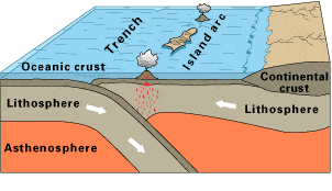
Observe this diagram of a plate boundary. One statement BEST describes what is happening. It is that
the oceanic crust is melting.
the denser ceanic crust is subducting under the less dense oceanic crust
volcanic islands are forming.
the tectonic plates are moving away from each other.
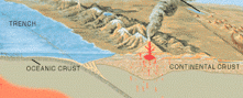
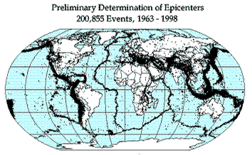
Earthquake epicenters (center of where the earthquakes started) were mapped for a 35 year period in the diagram above. The black dots indicate these epicenters. The black dots appear along what feature on Earth?
hot spots
plate boundaries
rift zones
sea floor spreading
The 2004 Indian Ocean tsunami was caused by a shift in two plates that pushed one section of the sea floor under another section of the sea floor by 5 meters. What type of boundary is this?
divergent
convergent
transform
metamorphic
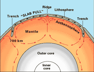
What is the source of energy that drives plate movement?
the subducton of the sea floor
the different densities of the oceanic and crustal plates
convection currents in the asthenosphere
the friction force between the plates that move past each other

Below is a picture of sea-floor spreading. How are the ocean crusts moving?
Converging
Diverging
Sliding
No movement
The San Andreas Fault in California is known as an active earthquake area. What type of
boundary is it?
Converging
Diverging
Transform
Sea Floor Spreading
The rigid section of the earth that move as a unit is called..........
Gravitational Pull
Tectonic plates
All of the following are geologic features except..........
rift valley
earthquake
moutains

