
Font size
 Worksheets
The Hydrological Cycle and Rivers
Total questions: 60
Worksheet time: 30mins
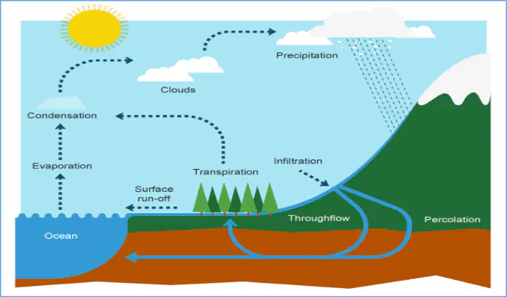
Define the following keyword: Evaporation.
Evaporation is the process by which water changes from a liquid to a gas or vapor.
Evaporation is the process by which water changes from a gas to a solid.
Evaporation is the process by which water changes from a solid to a liquid.
Evaporation is the process by which water changes from a gas to a liquid.
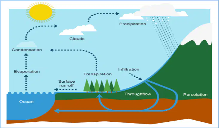
Define the following keyword: Transpiration.
Transpiration is the process by which water is absorbed by plants from the soil and then released as vapor into the atmosphere from their leaves.
Transpiration is the process by which plants convert sunlight into chemical energy through photosynthesis.
Transpiration is the process by which plants take in carbon dioxide from the atmosphere and release oxygen.
Transpiration is the process by which roots anchor the plant and absorb minerals from the soil.
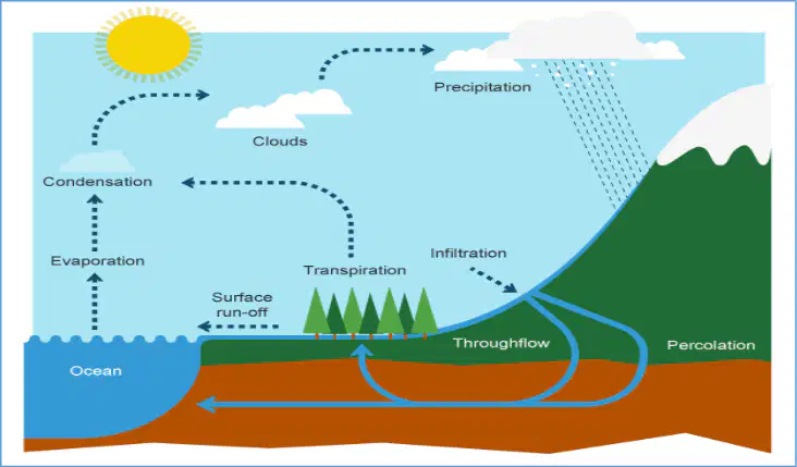
Define the following keyword: Condensation.
Condensation is the process by which water vapor in the air cools down and changes back into liquid droplets, forming clouds.
Condensation is the process by which solid ice turns directly into water vapor without becoming liquid.
Condensation is the process by which plants release water vapor into the air through their leaves.
Condensation is the process by which liquid water is heated and turns into water vapor.
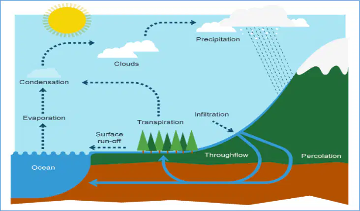
Define the following keyword: Precipitation.
Precipitation is any form of water, such as rain, snow, sleet, or hail, that falls from clouds to the Earth's surface.
Precipitation is the process by which plants make their own food using sunlight.
Precipitation is the movement of air from high pressure to low pressure areas.
Precipitation is the breaking down of rocks into smaller pieces by natural forces.
What is the process called when some water is stopped by vegetation and does not immediately reach the ground?
intercepted (interception)
evaporation
transpiration
percolation
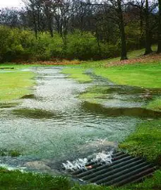
What is the term for water that flows across the surface of the ground when the surface doesn't allow water to penetrate?
surface runoff
groundwater recharge
evaporation
infiltration
What type of rock or ground condition makes surface run-off more likely to occur?
impermeable
permeable
porous
absorbent
What is the process called when water moves into the soil and moves within it?
infiltration
evaporation
condensation
transpiration
When rainfall or water flows through land and moves more slowly back to the river than surface run-off, what is this process called?
throughflow
evaporation
precipitation
condensation
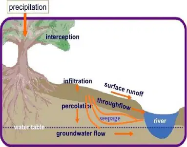
What is the process called when water moves downwards through the soil deeper into the ground and is slowly transferred back to the river or sea?
percolates (percolation)
evaporation
condensation
transpiration
What is the term for water that is stored in rocks following percolation?
groundwater
surface water
rainwater
runoff
The major ______ of water are the ocean, ice caps and snow, rivers, lakes, land and the atmosphere. The movement of water between these stores is called _______.
stores, transfers
sources, evaporation
types, condensation
forms, precipitation
Water in the hydrological cycle can be stored in which of the following places?
Ice and snow, lakes and rivers, ground water, oceans and seas
Only in the atmosphere
Only in plants and animals
Only in rivers and lakes
What is the annual average rainfall in the Maltese Islands?
530mm
1200mm
800mm
300mm
What percentage of water quickly evaporates due to high temperatures in the Maltese Islands?
65%
25%
40%
80%
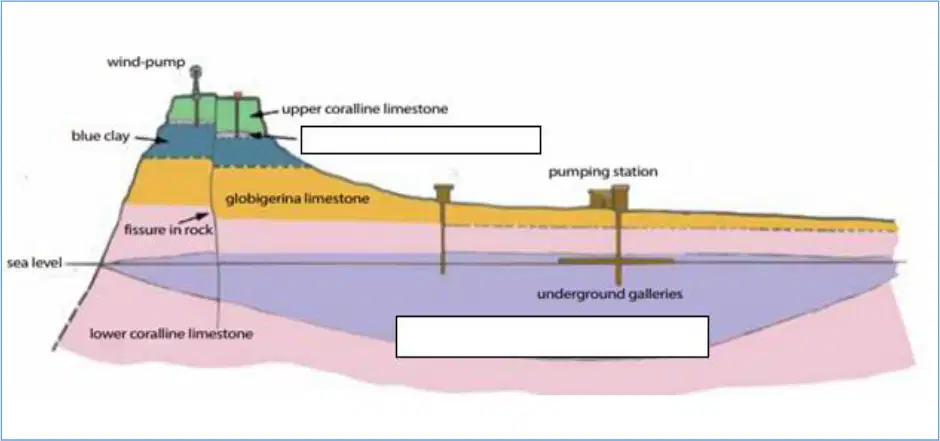
Look at the following diagram and label the perched aquifer and the mean sea level aquifer.
Perched aquifer: on top of the Blue Clay; Mean sea level aquifer: on top of the Lower Coralline Limestone at sea level.
Perched aquifer: below the Lower Coralline Limestone; Mean sea level aquifer: above the Blue Clay.
Perched aquifer: at sea level; Mean sea level aquifer: on top of the Blue Clay.
Perched aquifer: on top of the Lower Coralline Limestone; Mean sea level aquifer: below the Blue Clay.
Presently slightly less than half the water consumed in Malta is brought up from which source?
Rivers
Aquifers
Lakes
Desalination plants
More than half of the potable water produced in the Maltese Islands comes from reverse osmosis plants.
True
False
Name the three locations in Malta where reverse osmosis plants are found.
Pembroke, Siggiewi, and Cirkewwa
Valletta, Marsaxlokk, and Mdina
Sliema, Gozo, and Birzebbuga
Rabat, Qormi, and Mellieha
What is the main environmental concern associated with the use of reverse osmosis in Malta?
Large amounts of salty water are thrown back at sea causing great damage to the marine ecosystems.
It increases the amount of freshwater in the sea.
It causes air pollution due to chemical reactions.
It leads to excessive use of fertilizers in agriculture.
A river basin is an area of land drained by a river and its branches. What is this system a part of?
The hydrological cycle which operates on land.
The carbon cycle in the atmosphere.
The rock cycle beneath the earth's surface.
The nitrogen cycle in plants.
Match the following components of the river basin system with their descriptions:
Water entering the system
Inputs
Water moving within the system
Flows or Transfers
Water held within the systems
Stores
Leaving the system
Outputs
Read carefully the following descriptions and write down the keywords related to the river basin system. Description: Any form of liquid or frozen water that forms in the atmosphere and falls back to the Earth.
Precipitation
Evaporation
Transpiration
Runoff
Read carefully the following descriptions and write down the keywords related to the river basin system. Choose from the following: Percolation, Interception, Infiltration, Surface Storage, Precipitation, Throughflow Description: The total volume of water held on the Earth's surface stored in lakes, rivers, oceans and puddles. What is the correct keyword for the above description?
Surface Storage
Percolation
Infiltration
Throughflow
Read carefully the following descriptions and write down the keywords related to the river basin system. Description: The movement of water into underlying rocks.
Percolation
Evaporation
Transpiration
Runoff
Read carefully the following descriptions and write down the keywords related to the river basin system. Choose from the following: Percolation, Interception, Infiltration, Surface Storage, Precipitation, Throughflow Description: The horizontal movement of water in soil and rocks. What is the correct keyword?
Throughflow
Precipitation
Interception
Surface Storage
The movement of water into the soil from the surface.
Infiltration
Evaporation
Transpiration
Runoff
Read carefully the following descriptions and write down the keywords related to the river basin.
Main River
Watershed
Tributary
Source
Mouth
Tributary
Confluence
Confluence
Watershed
Main River
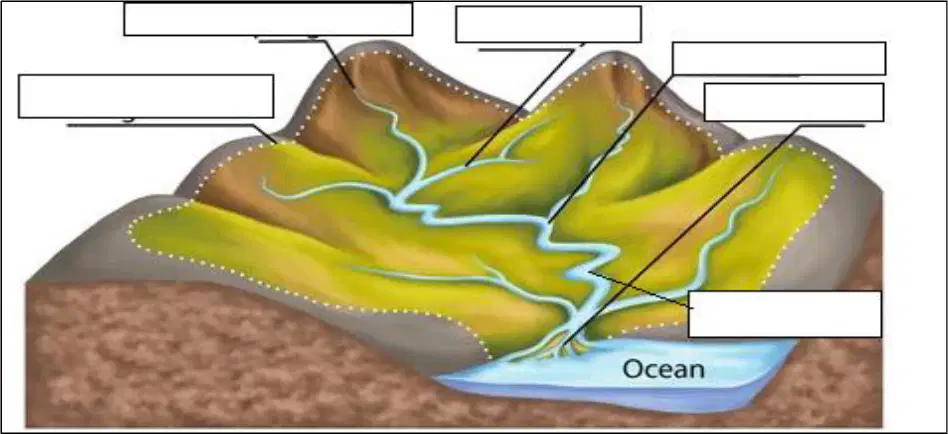
Now use the same keywords of exercise 6 to label the following diagram of the river basin.
The labels should be: Watershed, Source, Tributary, Confluence, Main River, Mouth (placed appropriately on the diagram).
The labels should be: Delta, Estuary, Floodplain, Rapids, Oxbow Lake, Meander (placed randomly on the diagram).
The labels should be: Glacier, Canyon, Plateau, Cliff, Valley, Ridge (placed randomly on the diagram).
The labels should be: Pond, Swamp, Marsh, Bay, Lagoon, Isthmus (placed randomly on the diagram).
Which of the following is a factor that can cause the land around a river to become saturated, leading to surface run-off?
Precipitation
Relief
Rock type
River discharge
Permeable rocks allow water to pass through pores and cracks, whereas impermeable rocks do not.
True
False
A steep valley is more likely to flood than a flatter valley because:
water runs off more quickly, increasing flood risk
the soil absorbs more water, reducing flood risk
there is less rainfall in steep valleys
steep valleys have more vegetation to absorb water
How does deforestation affect flood risk?
Deforestation increases flood risk because water will not be intercepted and will flow into the river.
Deforestation decreases flood risk because it creates more space for water to be absorbed.
Deforestation has no effect on flood risk because rivers control flooding.
Deforestation prevents flooding by increasing soil absorption.
When an area surrounding a river is built on, what happens to the flood risk and why?
Flood risk increases because of the increase in impermeable surfaces like tarmac and concrete, which cause more water to flow directly into the river.
Flood risk decreases because buildings absorb excess water from rainfall.
Flood risk remains the same because rivers naturally control water flow regardless of surrounding surfaces.
Flood risk decreases because more vegetation is planted around buildings to absorb water.
If dams are placed in the middle of a river, what is the effect on river flow and discharge?
River flow is controlled, causing more discharge before the dam and less below the dam.
River flow becomes uncontrolled, increasing discharge below the dam.
River flow is unaffected, and discharge remains the same throughout.
River flow is reversed, causing more discharge upstream than downstream.
Fill in the description for the following process of erosion: Hydraulic action.
Hydraulic action is the force of the water hitting the river bed and banks, causing material to be dislodged and carried away.
Hydraulic action is the process where rocks are dissolved by acidic water.
Hydraulic action is when wind blows sand against rocks, wearing them down.
Hydraulic action is the process of plants breaking apart rocks with their roots.
Fill in the description for the following process of erosion: Attrition.
Attrition is when rocks and stones carried by the river knock against each other and break into smaller, smoother pieces.
Attrition is when the river dissolves soluble minerals from rocks.
Attrition is when the river deposits sediment along its banks.
Attrition is when water seeps into cracks in rocks and freezes, causing the rocks to break apart.
Fill in the description for the following process of erosion: Abrasion (Corrosion).
Abrasion (Corrosion) is when the load the river is carrying scrapes along the bed and banks, wearing them away.
Abrasion (Corrosion) is when water dissolves soluble minerals from the river bed and banks.
Abrasion (Corrosion) is when air trapped in cracks in the river bank causes the rock to break apart.
Abrasion (Corrosion) is when the river drops its load due to a decrease in energy.
Fill in the description for the following process of erosion: Solution (Corrosion).
Solution (Corrosion) is when soluble materials dissolve in the water and are carried along in solution.
Solution (Corrosion) is when rocks are broken down by freeze-thaw action.
Solution (Corrosion) is when pebbles grind against each other, becoming smaller and rounder.
Solution (Corrosion) is when large rocks are rolled along the river bed by the force of the water.
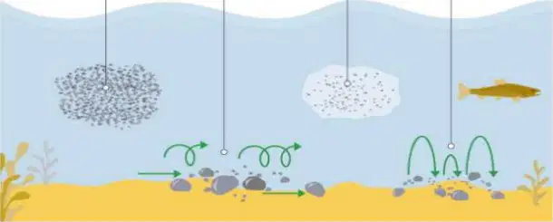
Fill in the blank: Describe the process of 'Traction' as a way by which a river can transport material.
Traction is the process where large rocks and boulders are rolled along the river bed by the force of the water.
Traction is the process where dissolved minerals are carried in solution by the river water.
Traction is the process where fine particles are suspended and carried within the water flow.
Traction is the process where small pebbles and stones bounce along the river bed in a series of short jumps.
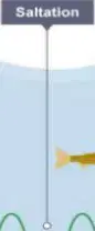
Fill in the blank: Describe the process of 'Saltation' as a way by which a river can transport material.
Saltation is the process where small pebbles and stones are bounced along the river bed in a leap-frogging motion.
Saltation is the process where dissolved minerals are carried in solution by the river water.
Saltation is the process where large boulders are rolled along the river bed by the force of the water.
Saltation is the process where fine particles are suspended and carried within the river flow.
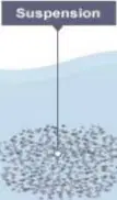
Describe the process of 'Suspension' as a way by which a river can transport material.
Suspension is the process where fine, light material is carried along in the water.
Suspension is the process where large boulders are rolled along the river bed.
Suspension is the process where dissolved minerals are carried in solution.
Suspension is the process where pebbles are bounced along the river bed.
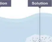
Fill in the blank: Describe the process of 'Solution' as a way by which a river can transport material.
Solution is the process where minerals are dissolved in the water and carried along in solution.
Solution is the process where large rocks are rolled along the river bed.
Solution is the process where sand and gravel bounce along the river bed.
Solution is the process where fine particles are suspended in the water.
When are energy levels in a river usually highest?
Near a river's mouth, when its course is flat and wide
Near a river's source, when its course is steep and its valley narrow
When the river enters a lake or sea
When the river is dry
What is a long profile in the context of rivers?
A line representing the river from its source to its mouth
A type of river landform
The speed of the river flow
The amount of water in the river
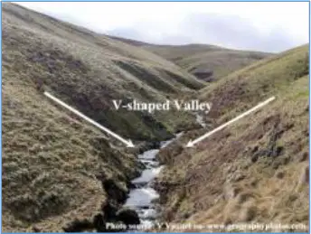
What is a V-shaped valley?
A valley formed by deposition
A valley formed by rivers eroding the landscape vertically, cutting a deep notch down into the landscape
A valley found only at the river mouth
A valley with no water flow
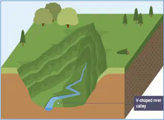
After periods of heavy rain, soil on the valley sides slowly moves downhill under gravity. What shape does the valley form as it is deepened faster than it is widened?
U-shaped valley
V-shaped valley
Flat plain
Canyon
What do we call the erosional process that takes place when material is moved along the bed of the river and collides with each other?
Attrition
Solution
Suspension
Deposition
What is a meander in the context of river landforms?
A straight section of a river
A bend in the river
A waterfall
A delta
The formation of a meander is due to both ______ and deposition.
erosion
condensation
evaporation
precipitation
What is an oxbow lake?
A lake formed by volcanic activity
A lake formed when a meander is cut off from the main channel
A lake formed by glacial melting
A lake formed by rainfall
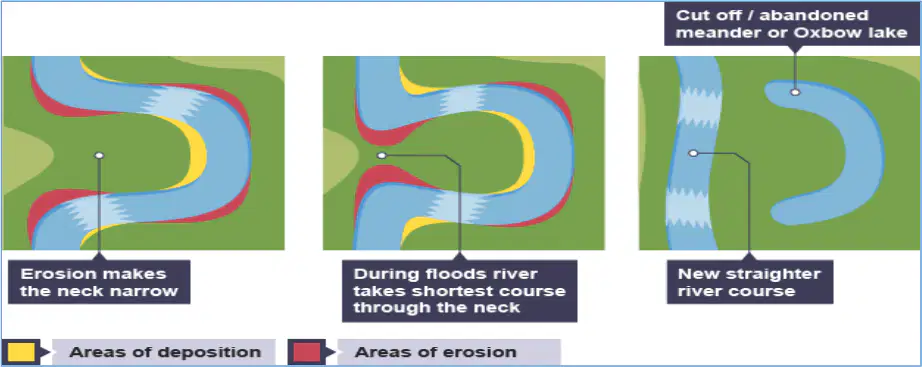
What process causes the neck of a meander to become narrow?
Erosion
Deposition
Flooding
Sedimentation
What is alluvium?
Alluvium is a layer of silt deposited by the river in times of floods, which is very fertile.
Alluvium is a type of volcanic rock found in mountains.
Alluvium is a layer of ice formed in polar regions.
Alluvium is a mineral extracted from deep mines.
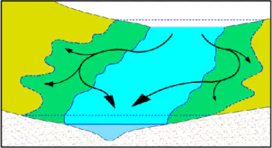
Why are floodplains considered good places for agriculture?
Floodplains are considered good places for agriculture because the river deposits fertile silt or alluvium on the flood plain every time it floods its banks.
Floodplains are considered good places for agriculture because they are always dry and never experience flooding.
Floodplains are considered good places for agriculture because they are located far from any water sources.
Floodplains are considered good places for agriculture because they have rocky soil that is difficult to cultivate.
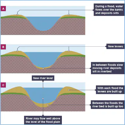
What are levees (embankments) and how are they formed?
Levees are embankments formed by the repeated flooding of the river. When the river floods, the biggest, heaviest and coarsest material will be dumped close to the river banks, building up over time to form levees on each side of the river banks.
Levees are natural hills formed by wind erosion over thousands of years, far from river banks.
Levees are artificial walls built to separate two different ecosystems in a forest.
Levees are underground tunnels created by the movement of groundwater beneath the river.
What is a delta and how is it formed?
A delta is found at the mouth of large rivers, where the river deposits its material faster than the sea can remove it, forming new land.
A delta is a mountain formed by volcanic eruptions near the river source.
A delta is a deep underwater trench created by ocean currents.
A delta is a sand dune formed by wind at the river bank.
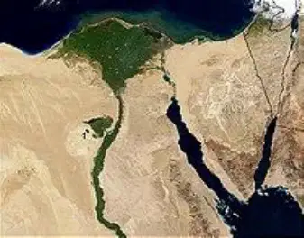
Which of the following is an example of an arcuate (fan-shaped) delta?
Nile Delta in Egypt
Mississippi River Delta
Amazon River Delta
Ganges Delta
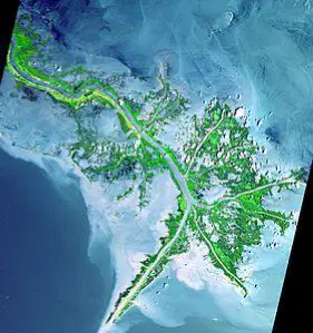
Which of the following is an example of a bird’s foot delta?
Nile Delta in Egypt
Mississippi River Delta
Amazon River Delta
Ganges Delta
Fill in the blank: Deltas are usually very ______ agricultural areas, but are also very prone to flooding.
fertile
arid
rocky
barren
Read carefully the following descriptions and match with their appropriate definition:
Oxbow lake
A u-shaped lake that forms when a wide meander is cut-off from the main river.
Levées
Also known as embankments; formed when coarse material is deposited on each side of the river banks.
Meander
A bend in the river formed through erosion and deposition.
Delta
The point where deposition takes place at the mouth of a river.
Lateral erosion
The point along the river, when erosion happens sideways.

