
 Worksheets
Physical Features of North America
Total questions: 61
Worksheet time: 33mins

SSWG1: Physical characteristics of place such as landforms, bodies of water, climate, and natural resources act as contributing factors to world settlement patterns because they:
influence where people choose to live and develop communities.
determine the language spoken in a region.
control the political systems of countries.
dictate the fashion trends in different areas.
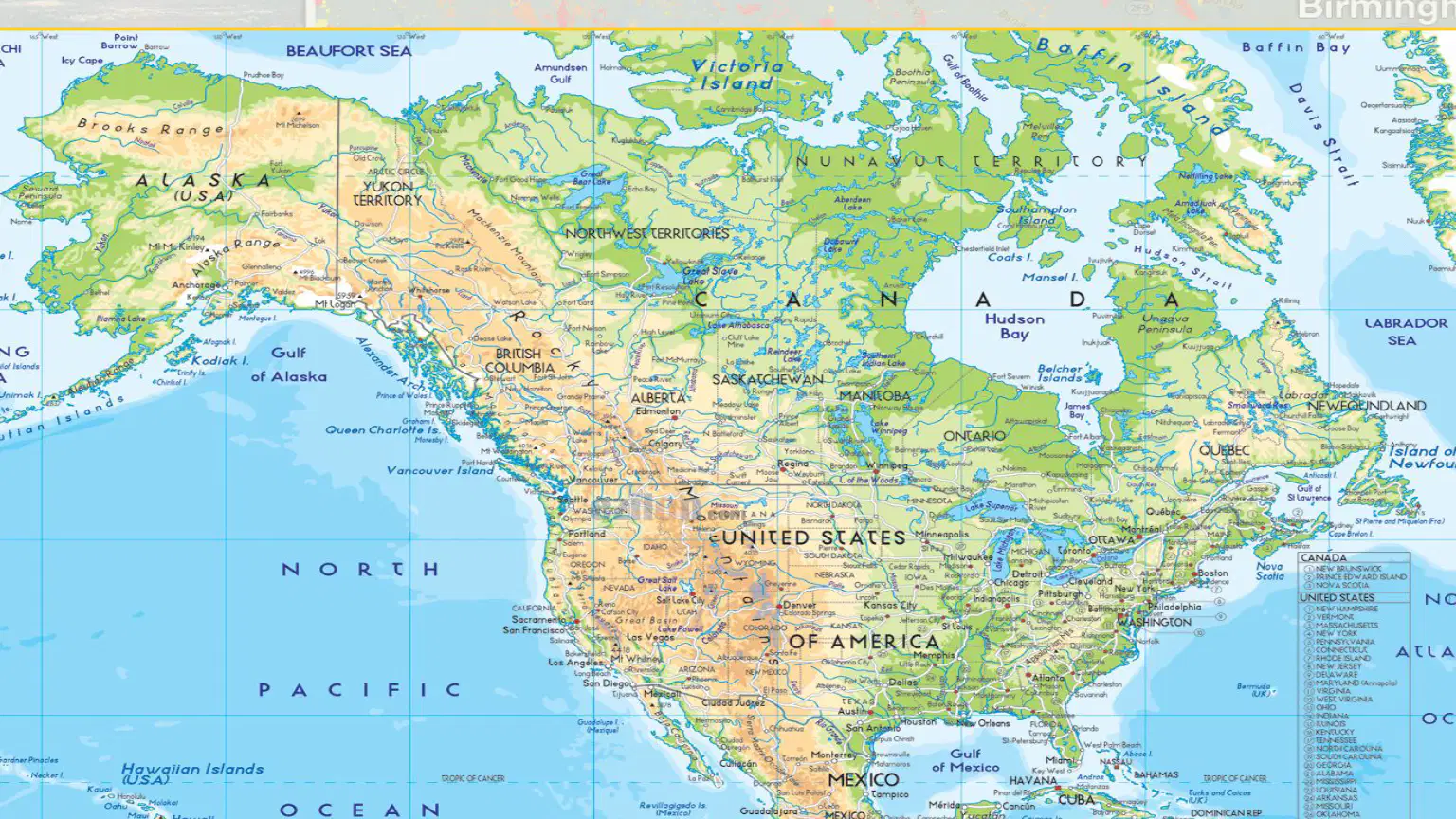
Refer to the map of North America: Climate, Physical Features, and Settlement Patterns. Which country is located directly north of the United States?
Mexico
Canada
Greenland
Cuba

The Rocky Mountains are primarily located in which two countries?
United States and Canada
Mexico and United States
Canada and Greenland
United States and Cuba

The Gulf of Mexico is located to the southeast of which country?
Canada
United States
Greenland
Cuba

Refer to the map of North America: Climate, Physical Features, and Settlement Patterns. Fill in the blank: The ________ Islands are located in the North Pacific Ocean, southwest of Alaska.
Aleutian
Hawaiian
Bermuda
Canary

What is the name of the large bay located in northeastern Canada?
Hudson Bay
Bay of Fundy
James Bay
Baffin Bay
Which of the following best describes North America?
The smallest continent
The third-largest continent
The largest continent
An island
North America is a diverse continent with a wide range of ______ and physical features.
climates
languages
currencies
festivals
Landscapes, climate, and availability of water have significantly influenced where people have ______ and how they live.
settled
traveled
studied
played

According to the map, which region in North America is labeled as 'Arctic'?

Name two types of forests found in North America according to the map legend.
Coniferous and Deciduous forests
Rainforest and Mangrove forests
Boreal and Tropical forests
Savanna and Desert forests
What type of climates are experienced from the north to the south?
Only tropical
Only arctic
A variety of climates, from arctic in the north to tropical in the south
Only temperate
How does climate affect plant and animal life?
Climate affects plant and animal life, which in turn influences economic activities.
Climate has no effect on plant and animal life.
Climate only affects animal life, not plants.
Climate only affects plant life, not animals.

Which economic activities are more suitable for the warmer climates in the south?
Forestry and mining
Growing crops like cotton and citrus fruits
Ice fishing
Skiing

Which economic activities are better suited for the colder climates in the north?
Growing citrus fruits
Forestry and mining
Surfing
Rice farming
Mountains are a landform that rises prominently above its surroundings, generally exhibiting steep slopes, and are formed when the Earth's ________ smashed together or converged.
tectonic plates
atmosphere
oceans
continents
One of the major ways that mountains can impact human settlements is by creating a phenomenon known as a ________.
rain-shadow effect
urban heat island
lake-effect snow
continental drift
What is a rain shadow? Fill in the blank: A rain shadow is a patch of land that has been forced to become a desert because mountain ranges blocked all plant-growing, ______ weather.
rainy
windy
cold
sunny
On the rain shadow side of the mountain, what happens?
Weather systems drop rain and snow.
All the precipitation is blocked.
The soil becomes wet and fertile.
The air cools and condenses.
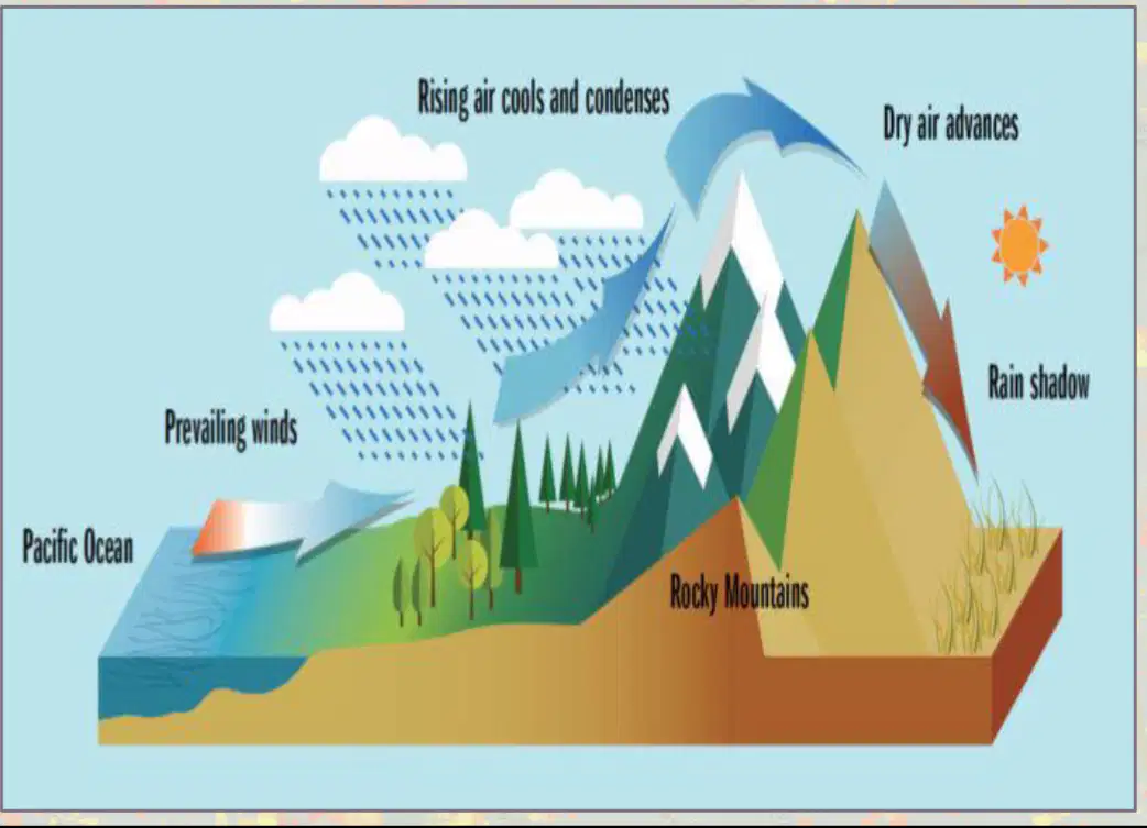
Based on the diagram, which side of the mountain receives more rain?
The side facing the Pacific Ocean
The rain shadow side
Both sides receive equal rain
The side facing the sun
Which mountain range is most dominant in the eastern portion of North America: _________.
Appalachian Mountains
Andes Mountains
Alps
Himalayas
Which mountain range dominates the states of Utah, Colorado, Arizona, and New Mexico in North America: _________.
Rocky Mountains
Andes Mountains
Himalayas
Alps
One of the most dominant mountain ranges in North America, not located in the Incited States: _________.
Canadian Shield
Andes Mountains
Alps
Himalayas

According to the map of the Appalachian Mountains, which U.S. state is home to the Great Smoky Mountains?
Georgia
North Carolina
Tennessee
Alabama

Which of the following is NOT a state or province through which the Appalachian Trail passes?
Maine
New York
Ohio
Georgia
Fill in the blank: The Appalachian Mountains extend from the state of _______ in the south to the province of _______ in the north.
Alabama, Newfoundland and Labrador
Georgia, Quebec
Mississippi, Ontario
Tennessee, Nova Scotia
The Appalachian Mountains stretch from the southeastern part of the United States to the northeastern part of North America.
True
False
These mountain ranges form a natural boundary between which two regions of North America?
The western Coastal Plain and the Rocky Mountains
The eastern Coastal Plain and the Interior Lowlands
The Great Plains and the Pacific Coast
The Interior Lowlands and the Rocky Mountains
As the first American frontier, the Appalachians were a challenge for settlers attempting to cross and _________?
settle to the west.
return to the east.
trade with the north.
farm in the south.
The Rocky Mountains are located primarily in which part of North America?
Western North America
Eastern North America
Southern North America
Central North America
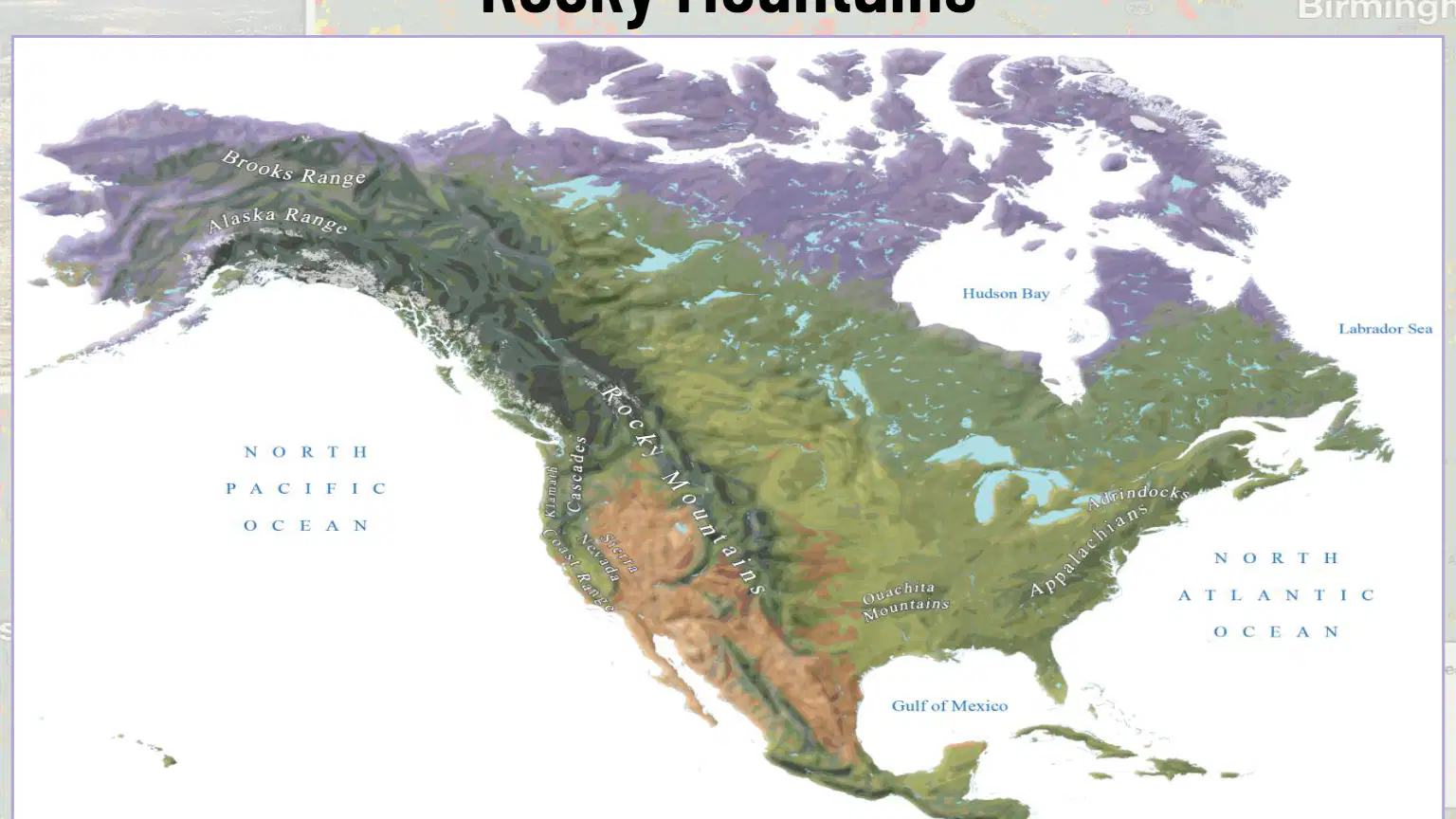
Name one body of water labeled on the map near the Rocky Mountains.
North Pacific Ocean
Lake Superior
Gulf of Mexico
Hudson Bay
Where does the Rocky Mountains chain begin and where does it extend to?
The Rocky Mountains chain begins in New Mexico and extends north through western Canada into Alaska.
The Rocky Mountains chain begins in California and extends south to Texas.
The Rocky Mountains chain begins in Florida and extends north to Maine.
The Rocky Mountains chain begins in Arizona and extends east to the Atlantic Ocean.
The Rocky Mountains are part of a system of parallel mountain ranges known as the _________?
Cordilleras
Andes
Appalachians
Himalayas
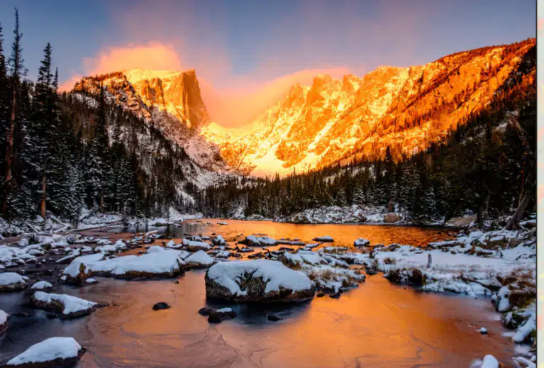
What is a cordillera?
A cordillera is a long series of mountain ranges.
A cordillera is a type of river.
A cordillera is a desert region.
A cordillera is a large forest.
Barrier to Expansion: The Rocky Mountains initially ________ westward expansion due to their rugged terrain and harsh climate.
hindered
encouraged
accelerated
facilitated
What did the mountains offer to attract settlers and miners?
Difficult terrain
Abundant natural resources
Lack of water
Few animals
Diverse Environments: The Rockies created distinct ecological zones, leading to varied agricultural practices and settlement patterns on either side. What was one impact of the Rockies on settlement patterns?
Uniform climate
Varied agricultural practices
No effect
Increased rainfall
What is the name of the mountain range shown in the image?
Appalachian Mountains
Rocky Mountains
Andes Mountains
Himalayas
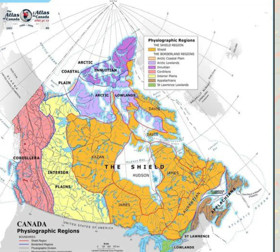
According to the map titled 'Canadian Shield,' which of the following provinces is entirely or partially covered by the Canadian Shield?
Alberta
Ontario
British Columbia
Yukon

Based on the map titled 'Canadian Shield,' what color represents the extent of the Canadian Shield?
Pink
Green
Blue
Yellow

According to the map titled 'Canadian Shield,' which of the following U.S. states is partially covered by the Canadian Shield?
California
Minnesota
Texas
Florida

According to the map titled 'Canadian Shield,' which large body of water is surrounded by the Canadian Shield?
Hudson Bay
Lake Superior
Great Bear Lake
Lake Ontario
What is the Canadian Shield?
A) A mountain range in South America
B) A vast region of exposed rock covering much of Canada and parts of the United States
C) A desert in Africa
D) An island in the Pacific Ocean
The Canadian Shield has a ______ climate, with long, cold winters and short growing seasons.
harsh
mild
tropical
arid
Why was it difficult for early settlers to rely on agriculture in the Canadian Shield?
The soil was too fertile
The region had long, cold winters and short growing seasons
There was too much rainfall
The area was covered in forests
According to the information provided, what has made it difficult for agriculture and limited population growth in the Canadian Shield?
Fertile soil and warm climate
Infertile soil and cold climate
High rainfall and dense forests
Proximity to the ocean
Most settlements in the Canadian Shield are concentrated near the Great Lakes or along the southern border where the ______ is more moderate.
climate
elevation
vegetation
soil

What is the name of the geographic region shown in the image?
Rocky Mountains
Canadian Shield
Appalachian Mountains
Great Plains

The main purpose of the map titled 'River Systems' is to:
show the locations and paths of major rivers.
display population density in different regions.
indicate the climate zones of the area.
highlight major cities and capitals.
According to the passage, what role did river systems serve in early America?
They were used only for recreation
They served as highways, carrying lifeblood to settlements
They were barriers to settlement
They were only used for fishing
River systems provided _______, food, and transportation, shaping where towns grew and how people interacted.
water
gold
timber
electricity
What are two major benefits that river systems provided to early American settlements, according to the passage?
They provided water and transportation (also food, and shaped where towns grew and how people interacted).
They provided gold and precious stones to early settlers.
They offered protection from wild animals and invaders.
They served as boundaries for different countries.
The Mississippi River is the ______ longest river in North America.
second
first
third
fourth
The Mississippi River has been vital for which of the following?
Transport of goods
Irrigation
Drinking water
Electricity
All of the above
Why did American Indians and European settlers find the Mississippi River watershed to be valuable?
Because it provided rich soil that is great for growing crops in the river valleys.
Because it was the only source of gold in North America.
Because it was the only place where trees could grow.
Because it was the only area with mountains.
Settlement in the areas around the Mississippi River watershed has been aided and hampered by the river system.
True
False

What is the name of the river shown in the image?
Colorado River
Mississippi River
Amazon River
Nile River
Where does the Colorado River rise from?
The Appalachian Mountains
The Rocky Mountains
The Sierra Nevada
The Andes
The Colorado River is often referred to as the "Lifeline of the ________."
Southwest
Midwest
Northeast
Southeast
Select the three states that the Colorado River passes through.
California, Arizona, Colorado
Texas, Nevada, Utah
Oregon, Idaho, Wyoming
Montana, New Mexico, Kansas
In which state does the Colorado River form the international boundary between the U.S. and Mexico for 17 miles?
Arizona
California
New Mexico
Texas

