
 Worksheets
Map Skills and Geography Tools Quiz
Total questions: 100
Worksheet time: 50mins
Which of the following is a part of a map that shows directions such as north, south, east, and west?
Compass rose
Scale bar
Grid line
Latitude
What is the main purpose of a scale bar on a map?
To show the direction of north
To measure distances on the map
To identify continents
To locate oceans
Which of the following best describes absolute location?
The general area where something is found
The exact coordinates of a place using latitude and longitude
The name of a continent
The direction from one place to another
Which tool would a geographer most likely use to find the exact location of a place on Earth?
GPS
Thermometer
Microscope
Stopwatch
If you wanted to compare the size of two countries on a map, which map feature would you use?
Compass rose
Scale bar
Key
Grid line
Why is it important to understand the difference between absolute and relative location?
It helps you find places more accurately and understand their relationship to other places.
It helps you draw better maps.
It helps you memorize country names.
It helps you identify map colors.
Which of the following is NOT a tool or technology used by geographers?
Globe
GPS
Aerial photography
Stethoscope
A student is given the coordinates 40°N, 74°W. What skill are they demonstrating if they use these coordinates to find a location on a map?
Identifying continents
Using absolute location
Drawing a compass rose
Naming oceans
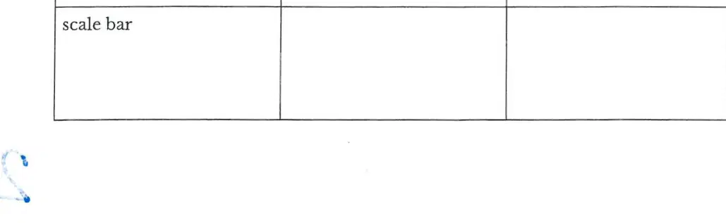
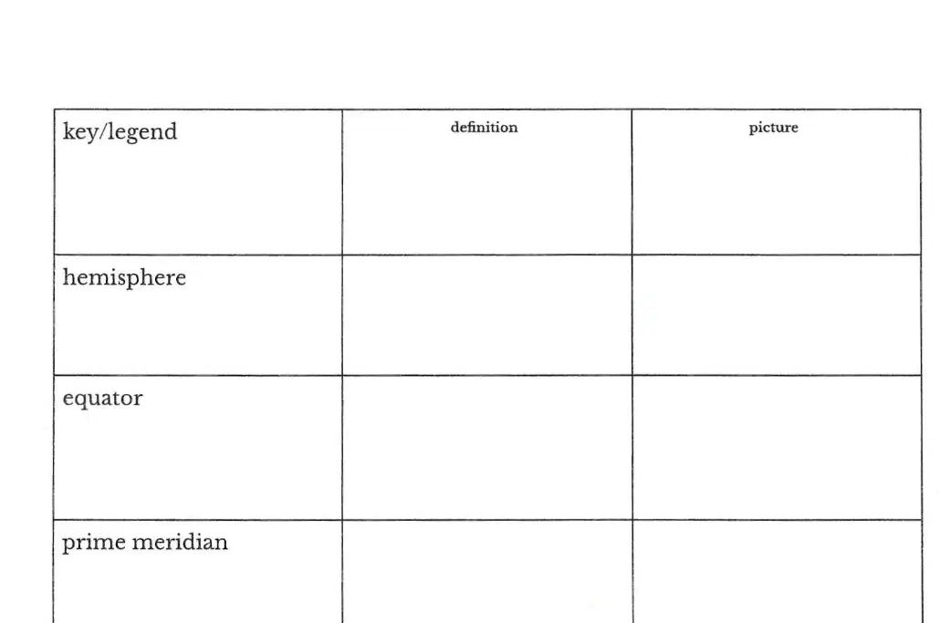
What is the purpose of the table shown in the image?
To list countries and their capitals
To define vocabulary words and draw their representations
To compare different types of maps
To record weather data
Which of the following terms refers to the imaginary line that divides the Earth into the Northern and Southern Hemispheres?
Prime meridian
Equator
Longitude
Latitude
What is the name for the imaginary line that divides the Earth into the Eastern and Western Hemispheres?
Equator
Latitude
Prime meridian
Absolute location
Which term describes the exact position of a place on Earth using coordinates such as latitude and longitude?
Relative location
Hemisphere
Absolute location
Key/legend
What does a key/legend on a map help you do?
Find the equator
Understand the symbols and colors used on the map
Measure distance between two points
Locate the prime meridian
If you are describing a place by saying it is "north of the river and next to the school," which term are you using?
Absolute location
Relative location
Longitude
Latitude
Which of the following best describes latitude?
Lines that run from the North Pole to the South Pole
Lines that measure distance east or west of the prime meridian
Lines that measure distance north or south of the equator
The exact address of a place
Longitude lines are used to measure which of the following?
Distance north or south of the equator
Distance east or west of the prime meridian
The size of a hemisphere
The meaning of map symbols
A map shows a circle divided into four equal parts. What concept does this best represent?
Key/legend
Latitude
Hemisphere
Absolute location
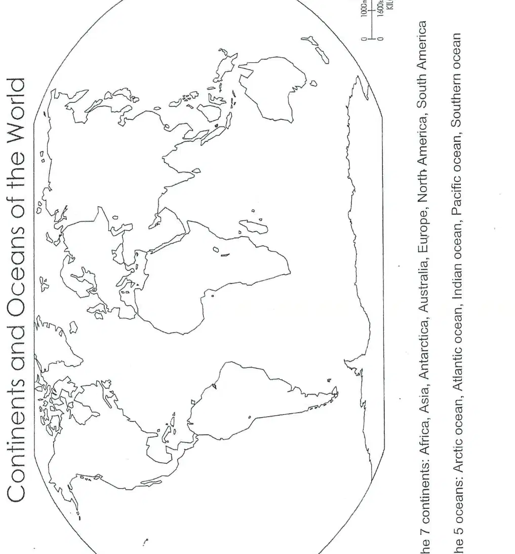
Which of the following is NOT one of the seven continents of the world?
Africa
Europe
Greenland
Australia

Which ocean is located between Africa, Asia, and Australia?
Atlantic Ocean
Indian Ocean
Pacific Ocean
Arctic Ocean

If you are asked to label the Southern Ocean on a blank map, which area would you focus on?
Around the North Pole
Around the equator
Around Antarctica
Around Europe

Why is it important to be able to identify and label the continents and oceans on a world map?
It helps in understanding world geography and global relationships.
It is only useful for coloring activities.
It is required for learning multiplication tables.
It is not important for any subject.
What does the title of a map tell you?
The symbols used on the map
The information the map is showing
The distance between places
The direction of north
What is another name for the key on a map?
Compass
Scale bar
Legend
Title
Which part of a map helps you figure out the distance between two places?
Compass rose
Key
Scale bar
Title
What does the compass rose on a map show?
The population of cities
The cardinal directions (north, south, east, west)
The types of landforms
The scale of the map
How are cities usually symbolized on a map?
By a star
By a triangle
By a solid circle
By a square
What do boundary lines on a map show?
The location of rivers
The extent of an area’s territory or political influence
The height of mountains
The direction of the wind
If you wanted to find the capital city on a map, which symbol would you look for?
A solid circle
A star
A square
A triangle
A student is looking at a map and wants to know what a certain symbol means. Which part of the map should they use?
Title
Key
Scale bar
Compass rose
Why is the scale bar important when using a map to plan a trip?
It shows the direction to travel
It explains the symbols on the map
It helps measure the real distance between places
It marks the location of cities
Imagine you are given a map without a compass rose. What challenge might you face?
Not knowing the meaning of symbols
Not knowing the distance between places
Not knowing which way is north, south, east, or west
Not knowing the names of cities
What is the main purpose of a compass rose on a map?
To show the scale of the map
To indicate directions
To display the map's title
To show the map's legend
How many directions can some elaborate compass roses indicate?
Four
Eight
Sixteen
Two
When a compass rose shows only one direction, which direction does it usually point to?
South
East
West
North
Which of the following is a cardinal direction?
Northeast
North
Southwest
Southeast
Which of the following is an intermediate direction?
North
South
East
Northeast
Why might someone create a phrase to remember the order of the cardinal directions?
To make maps look more interesting
To help remember the correct order easily
To decorate the compass rose
To show the scale of the map
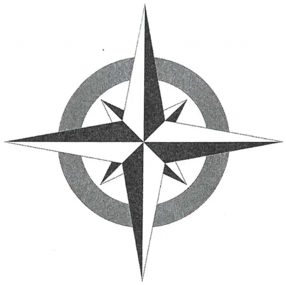
Look at the diagram below. What is this diagram called?
Map legend
Compass rose
Scale bar
Map grid
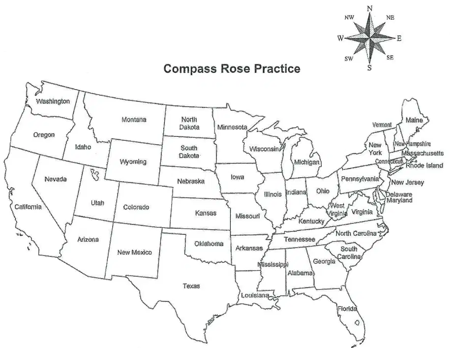
What is the direction of Ohio to Indiana?
East
West
North
South
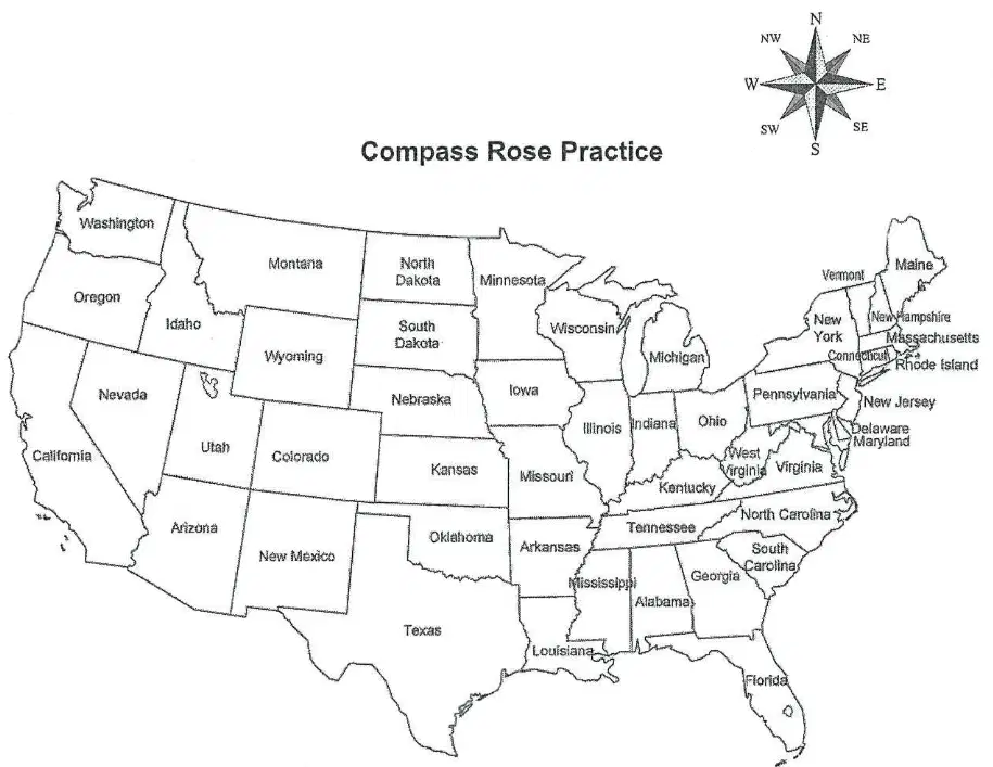
What is the direction of Indiana to Kentucky?
North
South
East
West
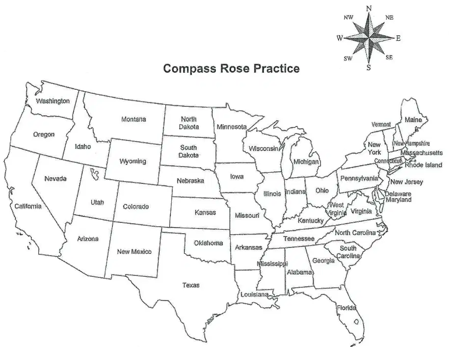
What is the direction of Kentucky to Missouri?
West
East
North
South
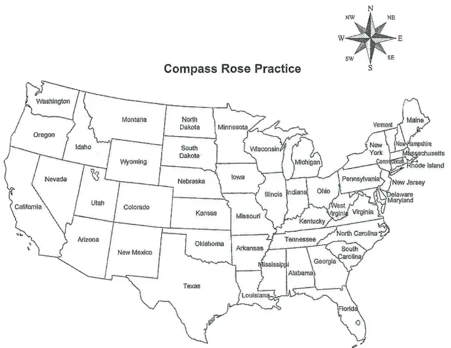
What is the direction of Missouri to Alabama?
Northeast
Southwest
Southeast
Northwest
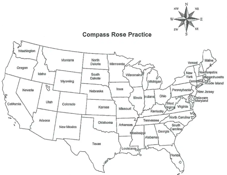
What is the direction of Alabama to North Carolina?
West
North
East
South
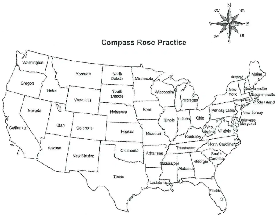
What is the direction of North Carolina to Pennsylvania?
North
South
East
West
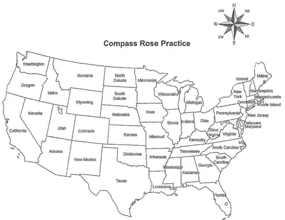
What is the direction of Pennsylvania to Texas?
Northeast
Southeast
Southwest
Northwest
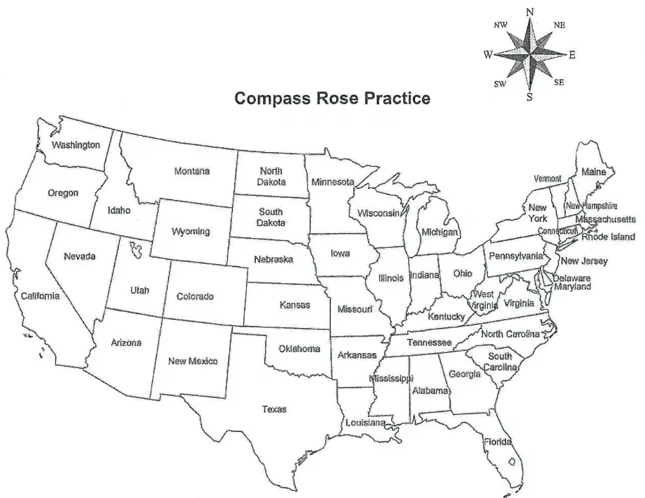
What is the direction of Texas to Louisiana?
East
West
North
South
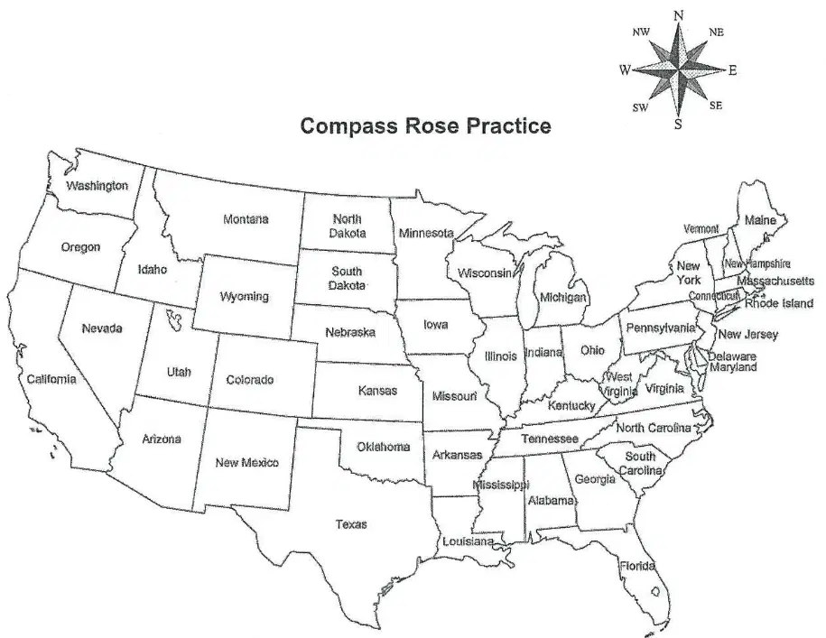
What is the direction of Louisiana to Colorado?
Northeast
Northwest
Southwest
North
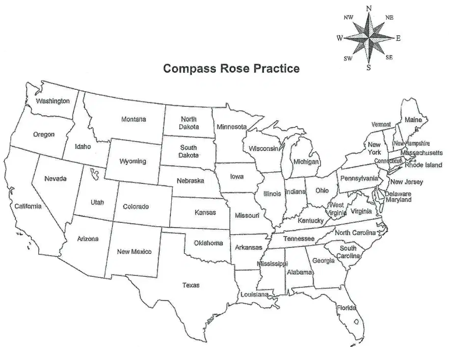
What is the direction of Colorado to South Dakota?
North
South
East
West
What is a map scale used for?
To measure distance on a map
To find directions on a map
To color maps
To write names on a map
According to the instructions, what should you do first when using a ruler to measure the scale bar on a map?
Start measuring from the right side
Line up the edge of your ruler with the left line of the scale bar
Draw a line on the map
Measure the whole map
If the scale bar shows that 1 inch equals 10 miles, how many miles would 2 inches represent on the map?
5 miles
10 miles
20 miles
15 miles
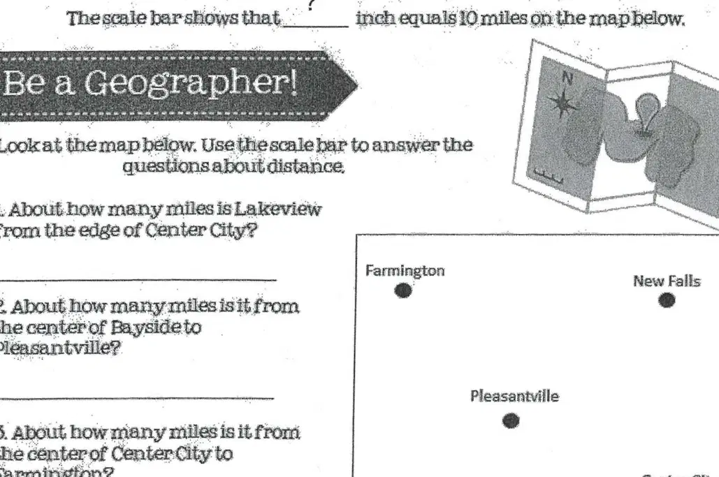
Using the map and the scale bar, which of the following is the best way to estimate the distance between two locations?
Measure the distance between the locations with a ruler and use the scale bar to convert to miles
Guess the distance by looking at the map
Count the number of locations between them
Use a calculator without measuring
Why is it important to use the scale bar when measuring distances on a map?
It helps you find the real distance between places
It makes the map look better
It tells you the names of places
It shows you which direction is north
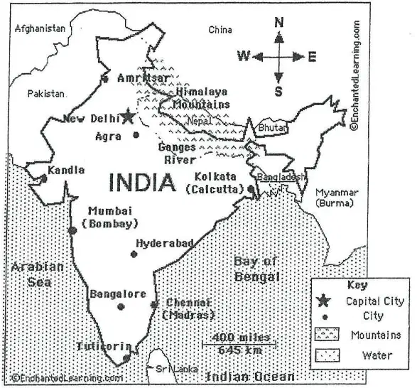
What is India's Capital City?
Mumbai
Kolkata
New Delhi
Hyderabad
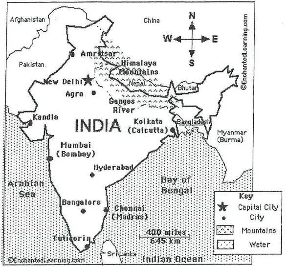
What do the black dots on the map represent?
Mountains
Cities
Rivers
Water bodies
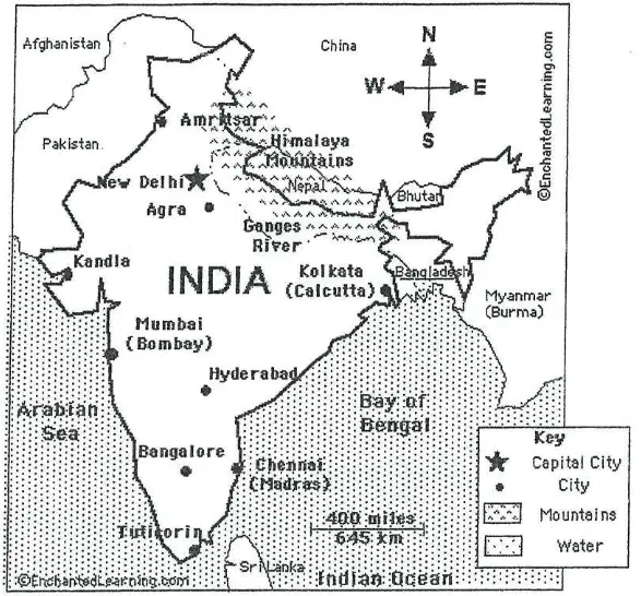
What body of water lies west of Bangalore?
Bay of Bengal
Arabian Sea
Indian Ocean
Ganges River
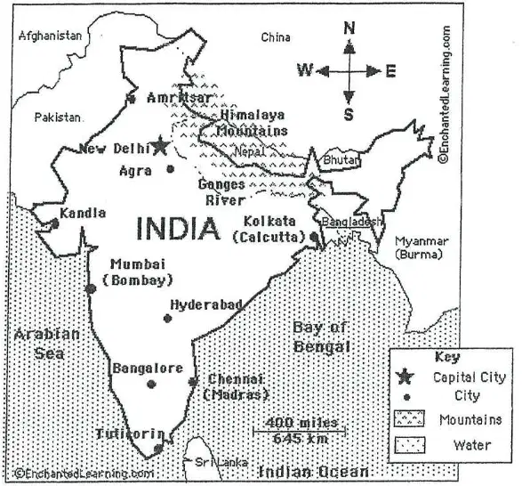
What direction would you travel to go from Hyderabad to Bangalore?
North
South
East
West
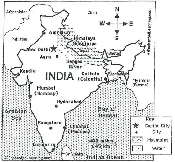
What direction would you travel to go from Bangalore to Kolkata?
West
North
East
South
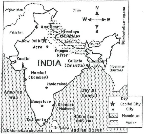
What mountain range lies northeast of Mumbai?
Himalaya Mountains
Western Ghats
Eastern Ghats
Vindhya Range
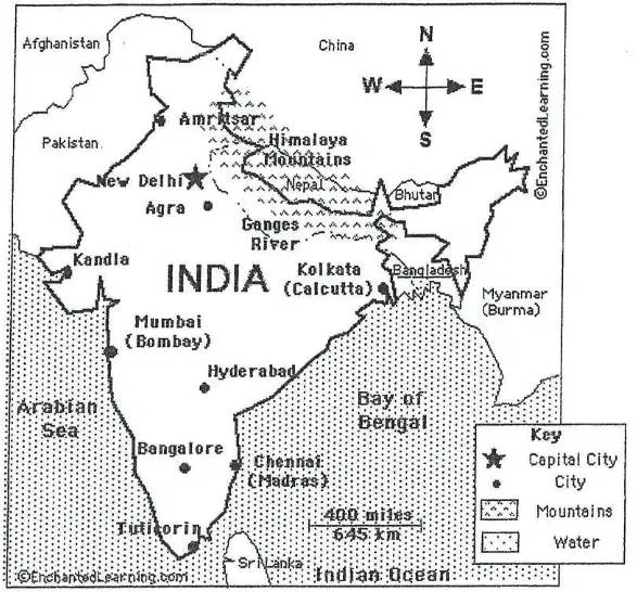
Using the scale bar, what is the distance between Mumbai and Hyderabad?
About 400 miles
About 100 miles
About 800 miles
About 200 miles
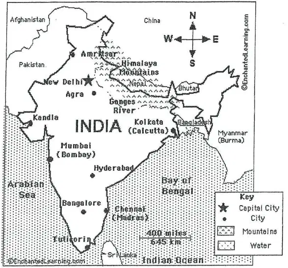
Using the scale bar, what is the distance between New Delhi and Chennai?
About 200 miles
About 800 miles
About 1,000 miles
About 400 miles
What does the Equator divide the world into?
Eastern and Western hemispheres
Northern and Southern hemispheres
Eastern and Northern hemispheres
Southern and Western hemispheres
What does the Prime Meridian divide the world into?
Northern and Southern hemispheres
Eastern and Western hemispheres
Northern and Eastern hemispheres
Southern and Western hemispheres
Which hemispheres is North America located in?
Northern and Eastern hemispheres
Southern and Western hemispheres
Northern and Western hemispheres
Southern and Eastern hemispheres
Which hemispheres is Australia located in?
Northern and Western hemispheres
Southern and Eastern hemispheres
Northern and Eastern hemispheres
Southern and Western hemispheres
Which hemispheres is Africa located in?
Northern and Western hemispheres
Southern and Eastern hemispheres
Northern and Southern, Eastern and Western hemispheres
Only in the Northern hemisphere
Which hemispheres is Asia located in?
Northern and Eastern hemispheres
Southern and Western hemispheres
Northern and Western hemispheres
Southern and Eastern hemispheres
What are lines of latitude?
Imaginary lines that go around the earth
Real lines that go from pole to pole
Lines that run vertically on the globe
Lines that only exist at the equator
What is another name for lines of latitude?
Meridians
Parallels
Longitudes
Axes
At what latitude is the equator located?
0°
90° N
90° S
30° N
Where is the South Pole located in terms of latitude?
90° N
0°
60° S
90° S
Where is the North Pole located in terms of latitude?
90° S
0°
90° N
60° N
The United States is in which hemisphere?
Northern Hemisphere
Southern Hemisphere
Eastern Hemisphere
Western Hemisphere
Most of South America is in which hemisphere?
Northern Hemisphere
Southern Hemisphere
Eastern Hemisphere
Western Hemisphere
Australia is located at which latitude?
30° S
30° N
60° N
0°
What does latitude describe about a location on Earth?
Its distance from the prime meridian
Its location in relation to the equator
Its altitude above sea level
Its population density
If a place is north of the equator, how is its latitude described?
In degrees South (° S)
In degrees North (° N)
In degrees East (° E)
In degrees West (° W)
If a place is south of the equator, how is its latitude described?
In degrees North (° N)
In degrees South (° S)
In degrees East (° E)
In degrees West (° W)
What does the equator divide the earth into?
Eastern and Western Hemispheres
Northern and Southern Hemispheres
Continents and Oceans
Poles and Tropics

What does the diagram illustrate?
The lines of latitude and their relation to the equator and poles
The movement of tectonic plates
The distribution of continents
The Earth's rotation around the sun

Which of the following is NOT one of the important latitude lines mentioned in the material?
Arctic Circle
Tropic of Cancer
Prime Meridian
Antarctic Circle

What is the latitude of the Tropic of Capricorn?
23 1/2° north of the equator
66 1/2° north of the equator
23 1/2° south of the equator
66 1/2° south of the equator

Which latitude line is located at 0°?
Tropic of Cancer
Equator
Arctic Circle
Antarctic Circle

If you were to label the 6 lines of latitude and longitude on a blank map, which of the following would you include?
Only the Equator and Prime Meridian
Only the Tropic of Cancer and Tropic of Capricorn
Arctic Circle, Tropic of Cancer, Equator, Tropic of Capricorn, Antarctic Circle, and Prime Meridian
Only the Equator, Tropic of Cancer, and Tropic of Capricorn

Why is it important to label the 7 continents and the 4 oceans on a world map?
It helps identify political boundaries.
It helps understand the physical geography of the Earth.
It is required for time zone calculations.
It is only important for navigation at sea.
What are lines of longitude also called?
Parallels
Meridians
Equators
Tropics
Where is the Prime Meridian located?
90° longitude
180° longitude
0° longitude
60° longitude
If a place is east of the Prime Meridian, its longitude would be in which direction?
West
North
East
South
Which hemisphere is South America mostly located in?
Eastern Hemisphere
Western Hemisphere
Northern Hemisphere
Southern Hemisphere
Most of Africa is in which hemisphere?
Western Hemisphere
Eastern Hemisphere
Northern Hemisphere
Southern Hemisphere
Why is the Prime Meridian sometimes called the Greenwich Meridian?
Because it passes through Paris
Because it passes through New York
Because it passes through Greenwich, England
Because it passes through Tokyo
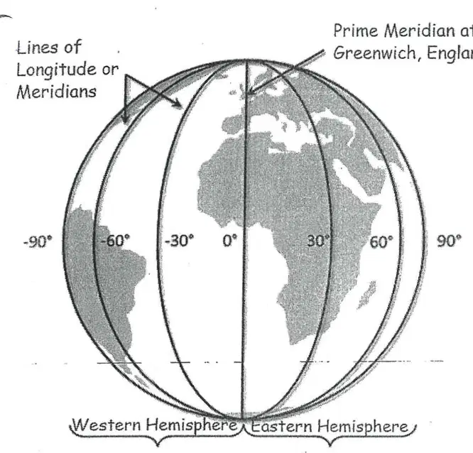
What do lines of longitude determine?
The distance from the Equator
The distance from the Prime Meridian
The distance from the North Pole
The distance from the International Date Line
What are the imaginary lines that run east to west around the globe called?
Latitude
Longitude
Meridian
Equator
Which line circles the middle of the Earth like a belt and is located halfway between the North and South Poles?
Prime Meridian
Equator
Tropic of Cancer
International Date Line
What does the letter 'N' or 'S' following the degree symbol in latitude indicate?
Whether the location is east or west of the Prime Meridian
Whether the location is north or south of the Equator
Whether the location is above or below sea level
Whether the location is in the Northern or Southern Hemisphere
What is the latitude of the North Pole?
0°
45°N
90°N
180°N
What are lines of longitude also known as?
Parallels
Meridians
Equators
Tropics
Which line is known as 0° longitude and runs through Greenwich, England?
Equator
Tropic of Capricorn
Prime Meridian
International Date Line
What does the letter 'E' or 'W' following the degree symbol in longitude indicate?
Whether the location is north or south of the Equator
Whether the location is east or west of the Prime Meridian
Whether the location is above or below sea level
Whether the location is in the Eastern or Western Hemisphere
What is the 180° meridian on the opposite side of the Earth from the Prime Meridian called?
Equator
Tropic of Cancer
International Date Line
Arctic Circle

