
 Worksheets
Social Studies Alive: Unit 1 Lesson 1 Quiz
Total questions: 19
Worksheet time: 31mins
Lines of _______ are imaginary lines that run from the North Pole
to the South Pole.
globe
government
landform
longitude
A sphere that is a model of the Earth is called a _______.
globe
government
landform
vegetation
Different plants make up the _______ of an area.
globe
government
length
vegetation
The _______ makes the laws in a country, state, or community.
globe
government
longitude
vegetation
A mountain is a type of _______.
globe
landform
length
vegetation
Which of these is a cardinal direction on a compass?
down
west
pole
northeast
Almost three quarters of the Earth's surface are covered by _______.
mountains.
plains.
forests.
water.
What is found at 0° Latitude?
the equator
the North Pole
the Greenwich meridian
the South Pole
Most of the Earth's water is
in rivers and lakes.
salt water.
a land form.
All of the above
The weather that can be measured over a long period of time is called
climate.
geography.
longitude.
vegetation.
Which of the following affects where people choose to live?
climate
physical feature
vegetation
all of the above
What do all maps have in common?
They all show physical features.
They are all created by collecting data.
They are all made from what people can see.
They all show the regions of the United States.

Two of the rivers that form part of the border of the United States are the ____________________ and the ____________________. (Only name one of them)
(a)

A tributary that flows into the Mississippi River from the east is the (a) .

A physical feature at 25°N, 90°W is (a) .
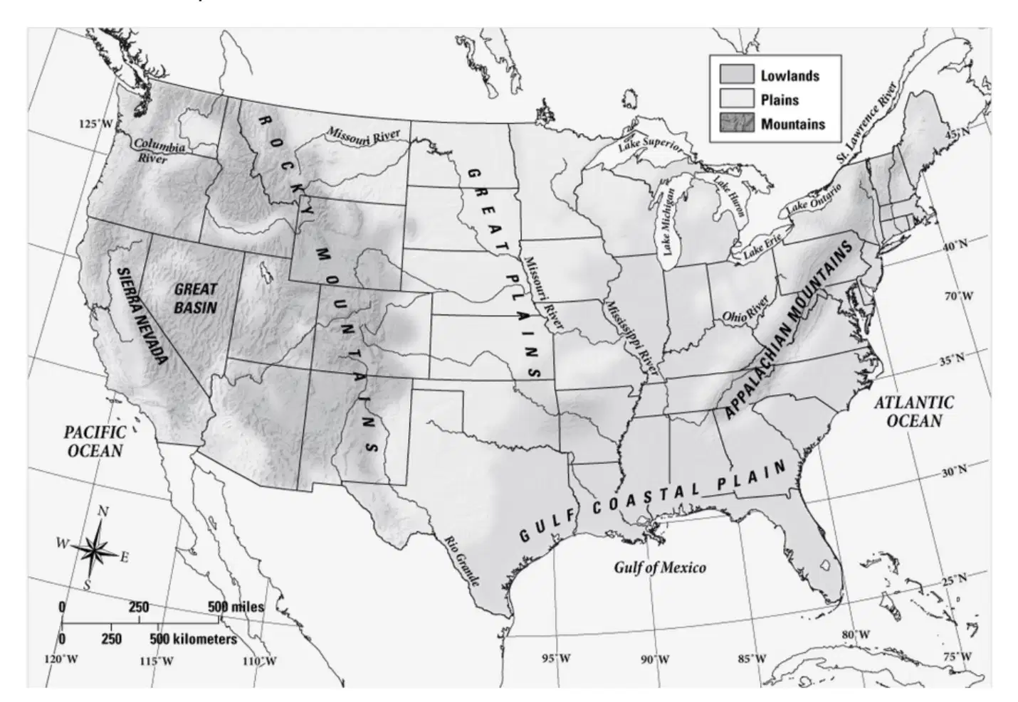
A geographic feature of the United States south of the Appalachian Mountains is the (a) .

The western tip of Lake Ontario is located at approximately ______ degrees north latitude and ______ degrees west longitude.
Write the answer as __ N, __W
(a)
Create a landscape that you would like to live in.
1. Draw a map with at least four physical features.
2. Mark where you would live.
3. Include a map key that explains the different symbols on your map.


Write a paragraph about why you would choose to live in the place you chose on your map. Be sure to include which resources would help you survive and how the environment would affect your life.

