
 Worksheets
Unit 1 Sec 1 Review
Total questions: 30
Worksheet time: 15mins
Name
Class
Date
1.
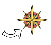
What direction is the arrow pointing?
a)
South East
b)
North East
c)
North West
d)
South West
2.
An ancient supercontinent with all present continents joined together
a)
Pangea
b)
Climate
c)
Weather
d)
Landforms
3.
The study of human and nonhuman features of earth.
a)
biology
b)
meteorology
c)
geography
d)
climate
4.
Which one isn't a theme of geography
a)
Movement
b)
Place
c)
Region
d)
Human
5.
Type of map that shows the major physical features of a region. These features include mountains, rivers, oceans, islands, deserts, and plains
a)
Physical Map
b)
Political Map
c)
Scale
d)
Geography Map
6.
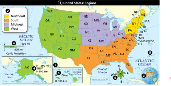
Identify what number 2 is on the map.
a)
map title
b)
compass rose
c)
map key
d)
locator map
7.
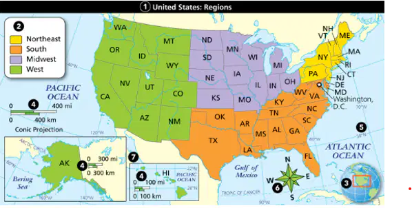
Identify what number 4 is on the map.
a)
map title
b)
scale bar
c)
map key
d)
locator map
8.
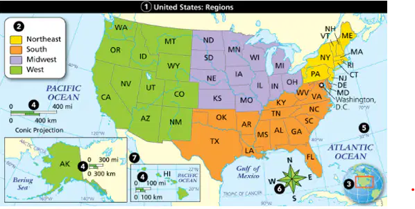
Identify what number 1 is on the map.
a)
map title
b)
scale bar
c)
map key
d)
locator map
9.
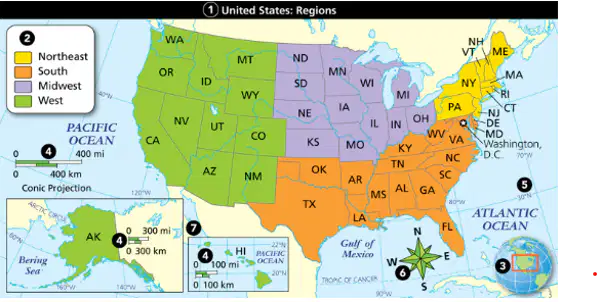
Identify what number 5 is on the map.
a)
map title
b)
scale bar
c)
map grid
d)
locator map
10.

Identify what number 3 is on the map.
a)
map title
b)
scale bar
c)
map grid
d)
locator map
11.
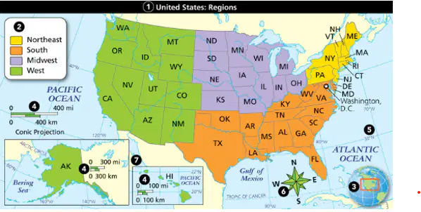
Identify what number 6 is on the map.
a)
compass rose
b)
scale bar
c)
map grid
d)
locator map
12.
What is the study of human and nonhuman features on earth?
a)
meterotology
b)
climatology
c)
geography
d)
biology
13.
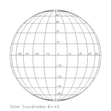
Imaginary lines that runs from east to west and is measured in degrees.
a)
Poles
b)
Prime Meriden
c)
Longitude
d)
Latitude
14.
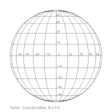
Imaginary lines that runs from north to south and is measured in degrees.
a)
Poles
b)
Prime Meridian
c)
Longitude
d)
Latitude
15.
Imaginary line that runs around the center of the earth that divides each half of the earth into hemispheres.
a)
Longitude
b)
Equator
c)
Latutude
d)
Prime Meridan
16.
Half of the earth. The four halves are the Northern Hemisphere, Southern Hemisphere, Eastern Hemisphere, and Western Hemisphere.
a)
Latitude
b)
Longitude
c)
Prime Meridan
d)
Hemisphere
17.
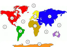
Name Continent G
a)
Antartica
b)
South America
c)
Asia
d)
North America
18.
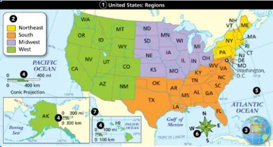
Identify what number 3 is on the map.
a)
Locator map
b)
Map Title
c)
Key
d)
Scale
e)
Compass rose
19.

What type of imaginary lines run horizontal on Earth?
a)
Latitude
b)
Prime Meridan
c)
Longitude
d)
Equator
20.
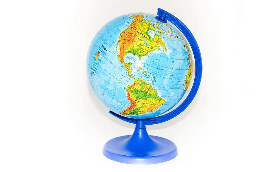
What Theme of Geography deals with relative and absolute?
a)
Movement
b)
Region
c)
Place
d)
Location
21.
What line divides the earth into Eastern and Western Hemispheres?
a)
Latitude
b)
Longitude
c)
Prime Meridan
d)
Equator
22.
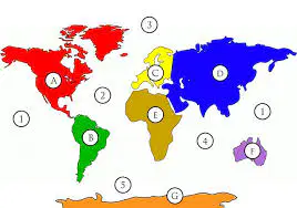
Continent F is ________.
a)
North America
b)
Europe
c)
Antarctica
d)
Australia
23.
The mobility of people, goods and ideas across various locations is which theme of geography?
a)
movement
b)
place
c)
location
d)
human-environment interaction
24.
A group of plants and animals that depend on each other and their environment for survival.
a)
Regions
b)
Canopy
c)
Ecosystem
d)
Map
25.
A natural feature of the Earth's Surface.
a)
Climate
b)
Deforestation
c)
Landforms
d)
Region
26.

Represents the distance between two locations on the map. Ex: 1 inch on the map equals 1 mile on the ground.
a)
Scale
b)
Map
c)
Globe
d)
Directions
27.
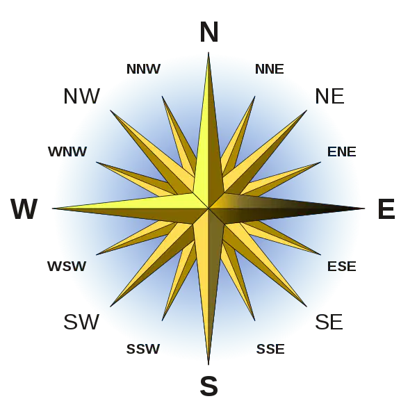
What direction is the black line pointing
a)
Northwest
b)
West
c)
South
d)
East
28.
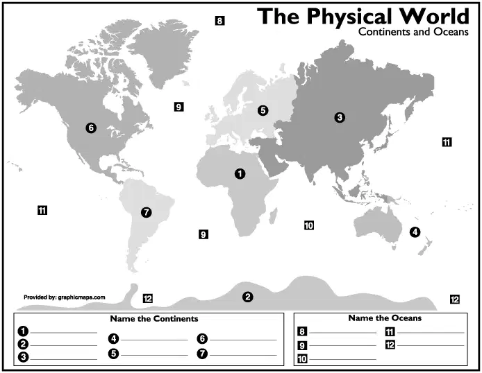
Name the Ocean with #8 The 5 Oceans are Pacific, Artic, Southern, Indian, Atlantic
a)
Atlantic
b)
Southern
c)
Artic
d)
Pacific
e)
Indian
29.

A small chart included on a map that gives descriptions of what symbols are used and what they stand for
a)
Key
b)
Scale
c)
Compass Rose
d)
Intermediate Directions
30.

This map shows boundaries defining nations, countries, states, provinces and territories and the major cities that lie within them
a)
Physical
b)
Weather
c)
Earth
d)
Political
100 %

