
 Worksheets
MP1 AP Human Geography 4 Wks Exam -2026-27
Total questions: 20
Worksheet time: 20mins

The meridians shown on the map calculate the
distance north and south of the equator
relative location of bodies of water to landmasses
distance east and west of the prime meridian
arrangement of objects on earth's surface in relationship to one another
organization of earth's surface into distinct areas that are viewed as different from other areas
Mathematical calculations using latitude and longitude allow us to determine the
relative location of a particular place
physical site characteristics of all places on earth
toponym of a particular place
absolute location of a particular place
arrangement of objects on earth's surface
Which of the following is a type of region categorization that emphasizes the relationship between core and peripheral areas?
formal regions
uniform regions
functional regions
perceptual regions
vernacular regions
Which of the following modern trends is most directly responsible for the phenomenon of space-time compression?
regionalization
globalization
democratization
fragmentation
acculturation
The art and science of map making is called
cartography
topography
physical geography
spatial analysis
territorial morphology
This computer system captures, stores, analyzes, and displays data. It measures the position of an object on Earth and stores it in a computer along with countless other specific measurements. Each type of information may be stored in a layer, and then layers may be combined to present the overall image.
Question: The statement above refer to which of the following?
A local global continuum
A GIS
U.S. Census Tracing
A GPS
A Spatial Data Pattern
Linear, centralized, random, and grid patterns help to define
position of something on earth's surface
arrangement of objects on earth's surface in relation to other objects
distance between objects on a map and the distance between objects on earth's surface
organization of earth's surface into distinct areas
physical gap or distance between two objects
Which of the following is NOT a physical site characteristics?
amount of rainfall
type of soil
elevation
the location of a smaller street in relation to a main street
type of vegetation
One way that possibilism differs from environmental determinism is that it emphasizes
climate
culture
history
regions
trade
A region that has an informal sense of place because people have a different views of what unites them, is an example of a
functional region
formal region
perceptual region
uniform region
Nodal region
Which of the following types of maps would have the largest scale?
World
Continent
State
City
Country
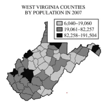
Use the image to answer the following question:
The map shown best fits which of the following type?
Cartogram
Choropleth
Proportional
symbol
Dot symbol
Isoline
Which of the following concepts could best be explained by the theory of possibilism?
Regional differences between the internal structures of cities
Changes in population growth rates over time
Limitations on agricultural crops based on climate
Political patterns seen in election maps
Modification of landscapes by human cultures
New York City's ________ is approximately 100 miles northeast of Philadelphia and 100 miles southwest of Boston.
location
site
situation
toponym
jurisdiction
Which of the following is most likely a functional region?
an area where new ideas seem to be circulating the fastest
the area of dominance of a particular church or sect
the area that a person regards as a hometown
the area of dominance of a television station
area where people tend to be fans of a particular professional football team
Which of the following best describes the idea of a cultural landscape?
The natural landscape of the mountains in any given country.
A landscape set aside for historical preservation, like a Civil War battlefield.
Land that has been developed with museums, concert halls, and schools.
A landscape where human activity has modified the natural environment in some way.
A landscape untouched by human activity, featuring mountains, rivers, and plants.
Read the definitions below and then answer the question that follows.
Watershed: A region in which all rainfall eventually flows downhill through a system of streams and tributaries into the same body of water, such as the catchment basin of a river or lake.
Milkshed: A region in which fresh milk is produced and can be delivered without spoilage for sale and consumption. A dairy farm sits at the center of an area, the size of which is determined by how far fresh milk can be shipped and still maintain shelf-life for consumers.
Given the definitions, watersheds and milksheds can best be classified as what type of region?
Culture
Formal
Functional
Industrial
Vernacular
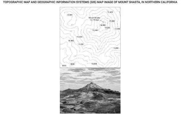
The images show a topographic map and a geographic information systems (GIS) representation of Mount Shasta in California. Which of the following statements best explains why these printed images are geometrically distorted representations of Earth’s surface?
Some maps do not show the actual coloration of Earth’s surface and vegetation.
GIS can only display two-dimensional layers.
The planet’s gravitational poles are not located at the poles of Earth’s axis.
The three dimensions of Earth’s surface are displayed on a two-dimensional page.
Printed maps alter the sense of place that people can have about a location.
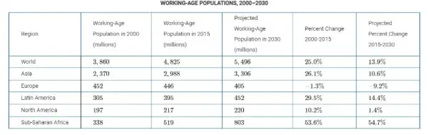
An international company is looking to expand its network of factories, which use labor-intensive production methods, in a region of the world experiencing significant growth in the working-age population. Based on the data in the table, which of the following regions should the company choose?
North America, which will have faster working-age growth in 2015 to 2030 than in 2000 to 2015
Asia, which will have a faster working-age growth rate in 2015 to 2030 than in 2000 to 2015
Latin America, which had the fastest working-age growth rate among world regions from 2000 to 2015
Asia, which will have the fastest working-age growth rate among world regions from 2015 to 2030
Sub-Saharan Africa, which will have the fastest working-age growth rate among world regions from 2015 to 2030
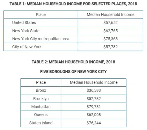
The data on median household income in Table 1 is presented in different
culture regions
physical regions
map scales
scales of analysis
vernacular regions

