Worksheets
World Geography: Unit 1 Review
Total questions: 35
Worksheet time: 21mins

Which of the following is not one of the 5 Themes of Geography?
latitude
place
location
location

What is the most probable reason for the patterns of settlement in Canada?
religion
climate
culture
mining activity
Which is more useful?
map
globe
Which are the 3 types of maps? (Mark all that apply)
cylindrical
thematic
physical
planar
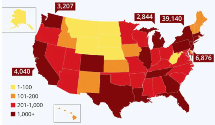
What type of map is this?
Thematic
Physical
Political
Topographic
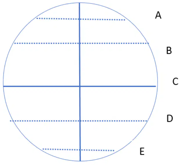
Where would the lines of low latitude be found?
North of line A and south of line E
Between lines A-B and D-E
Between lines B-C and C-D
South of line D and north of line C
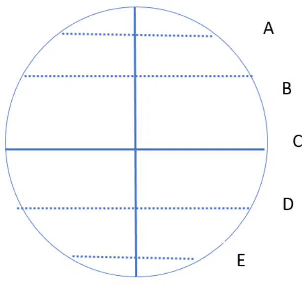
Where would the lines of high latitude be found?
North of line A and south of line E
Between lines B-C and C-D
Between lines A-B and D-E
What most affects the climate of an area?
Latitude
Longitude
A polar bear would most likely thrive in which latitude zone?
low
mid
high
We live in which latitude zone?
high
low
mid
What causes the seasons to change?
revolution
rotation
Chemical or physical process that breaks down rocks into smaller pieces
weathering
erosion
all of the above
none of the above

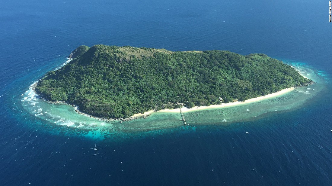
What is this?
plains
mountain
hills
Which climate zone has the widest temperature variation throughout the year?
temperate
tropical
polar
A biome is an ecological community with unique plant and animal species which are largely determined by the climate.
True
False
Weathering is the process of moving weathered material.
True
False
Place refers to the physical and cultural traits that make an area unique.
True
False
Air conditioning is an example of Human-Environment Interaction.
True
False
Acid rain would count as which type of weathering?
Chemical
Biological
Physical

Erosion is the process in which rocks are broken down.
True
False
An isthmus is a small strip of land connecting two larger pieces of land.
True
False
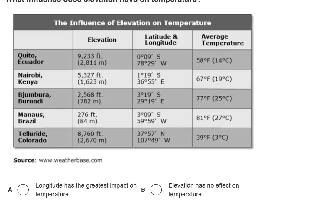
What influence does elevation have on temperature?
Longitude has the greatest impact on temperature.
Elevation has no effect on temperature.
The higher the elevation the higher the temperature.
The lower the elevation the higher the temperature.
The imaginary line that measures north and south 0-90 degrees is (a) and the imaginary line that measures east and west 0-180 degrees is (b)
The prime meridian is the line of (a) at (b) degrees.


What Landform is this?
Archipelago
Basin
Isthmus
Valley



10) Which point on the diagram correctly locates 15° S and 30° W?
Z
Y
X
W
What type of map is this?
Political map
Cartogram