
 Worksheets
Think like a Geographer
Total questions: 28
Worksheet time: 14mins

Based on the information in the maps above, which region of Texas has the most average rainfall in one year?
Great Plains
Central Plains
Coastal Plains
Mountain and Basin
If someone wanted to move to a region of Texas with mild winters and hot summers, which region would that be?
Great Plains
North Central Plains
Gulf Coastal Plain
Mountains and Basins
Which region of Texas includes the characteristics listed in the box?
Great Plains
Coastal Plains
North Central Plains
Mountain/Basin Area
Which physical characteristic is found in the Gulf Coast Plains region of Texas?
Tall forests
Sandy beaches
Deep canyons
Rugged mountains
Which landform is found in the Mountains and Basin region, but not in the Coastal Plains region of Texas?
Bayous
Canyons
Grasslands
Rivers
Not many cities are located in the Mountain and Basin Region of Texas. Why is this so?
The region lacks natural resources.
The region is dry and hard to farm.
The region is flat and uninteresting.
The region has too mild of a climate.

Look at the locations of the cities on the map. What can you tell about why cities grew where they did?
They were all in the mildest climate areas.
They were all close to sources of water.
They were all close to oil fields.
They were all in the southern part of the state.

Look at the map above of the State of Texas. What can you tell about the location of cities in the state?
They are all located along rivers.
They are all located on the coast.
They are all in the southern part of the state.
They are all located on highways.
Which city in the Coastal Plains is important to many industries?
Houston
Amarillo
El Paso
San Antonio
In which Texas region would you find people living near wind farms?
East Texas
Coastal Plains
Rocky Mountains
North Central Plains
How have many of the people living in the Great Plains region of Texas made a living?
Banking
Fishing
Ranching
Teaching
The tourism, oil and gas, and shipping industries all contribute to the economy of —
the Gulf Coast of Texas
the Panhandle of Texas
the Capital area of Texas
the Rio Grande Valley of Texas
Because of their location in the Permian Basin, the economies of Midland and Odessa are based largely on —
the cattle industry
the military industry
the aerospace industry
the oil extraction industry
The development of a timber industry in East Texas was facilitated by —
an access to harbors
an arid, humid climate
an abundance of forests
a large quantity of rivers
Many oil refineries in Texas are located along the coast. Why would this be a good location for an oil refinery?
It is in an area where there would be lots of workers.
It is in a region where the weather is usually very nice.
It is close to water needed to fight fires at oil refineries.
It is near shipping channels to transport oil to the refinery.
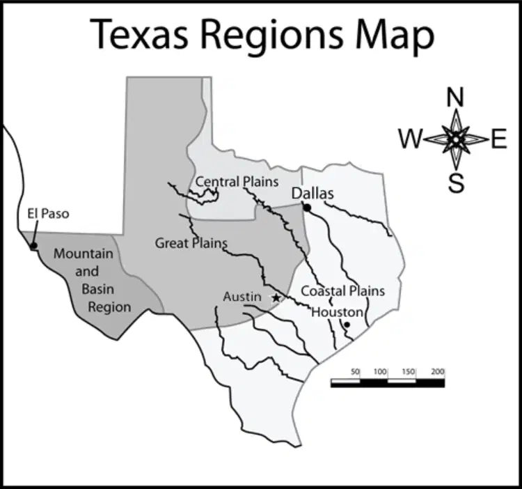
Using the scale on the map, approximately how far would you travel from Houston to Dallas?
100 miles
200 miles
500 miles
1,000 miles
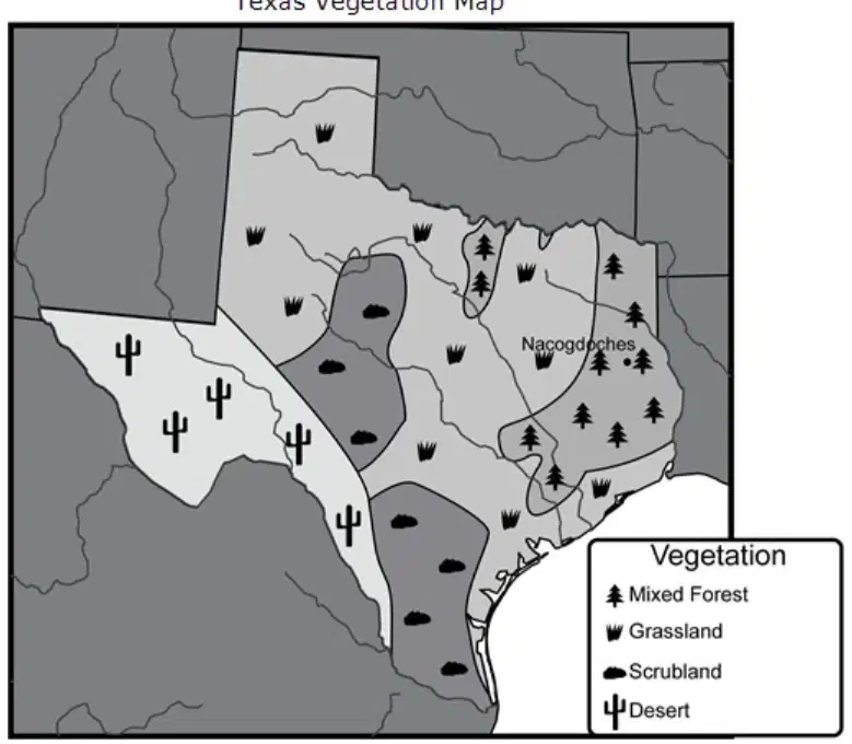
Based on the map, how does the pattern of vegetation in Texas change if you travel from east to west?
There are more trees and less grassland.
The vegetation gets taller and much larger.
The vegetation starts to include more piney woods.
There are more plants able to handle dry conditions.

Based on the map above, what type of vegetation is found in the area near the city of Nacogdoches?
Rice farms
Scrubland
Desert cactus
Mixed forests
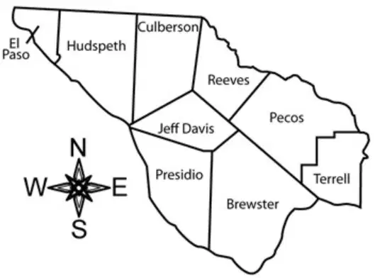
If you were to travel from Presidio County to El Paso County, in which direction would you be traveling?
Northwest
Southeast
West
East
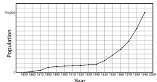
Which graph best represents the population changes in Austin, Texas over the years?
Graph F image
Graph G image
Graph H image
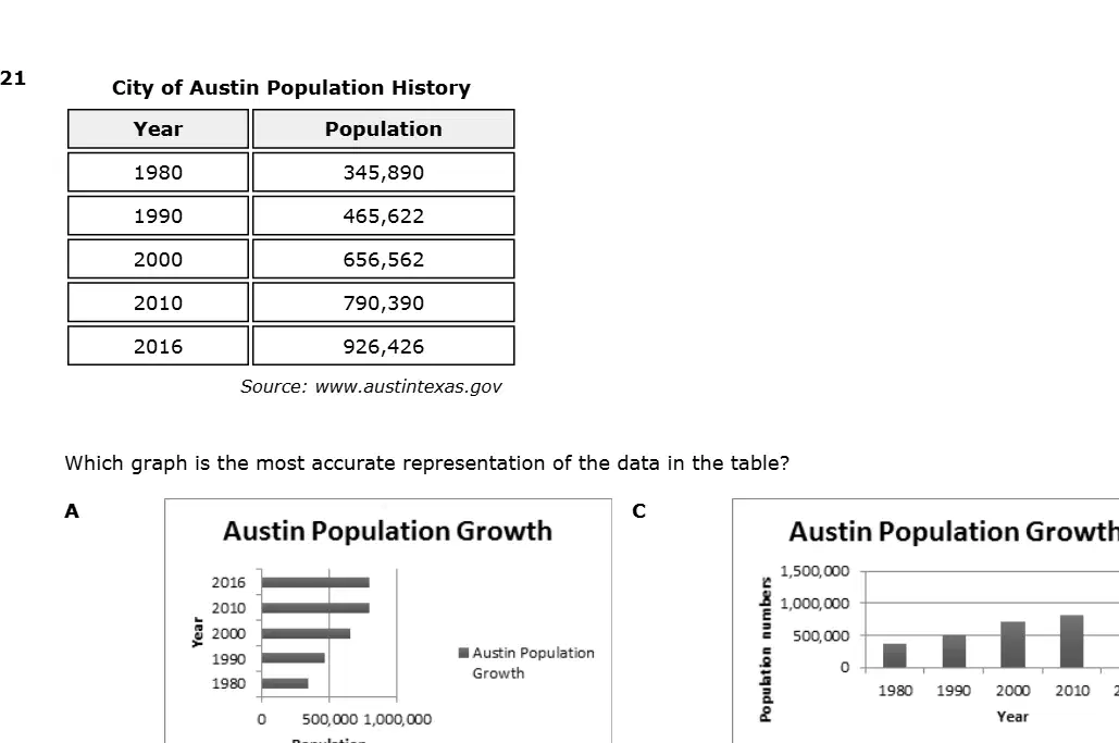
Which graph is the most accurate representation of the data in the table?
Graph A
Graph B
Graph C
Graph D
True or False: Political maps show the borders of countries, states, or other places.
true
false
Click on ALL of the correct answers. The four cardinal directions are
north
northeast
south
east
west
Someone who draws a map is called a
journalist
artist
cartographer
True or False: A map legend or key tells us what the different symbols on a map stand for.
true
false
A physical map shows
landforms like mountains, plains, deserts, and bodies of water.
workout centers.
only rivers.
A road map shows
only state borders.
only rivers.
highways and major roads.
Click all answers that are correct. A thematic map shows information about one theme like
population.
rainfall.
elevation.

