
Font size
 Worksheets
Map Skills and 5 Themes of Geography Test
Total questions: 20
Worksheet time: 3600secs
Which of the following best describes "absolute location"?
A place’s exact location on Earth
An area that shares common features
Features such as people, language, culture, etc.
How people, goods, and ideas move from place to place
What does the term "movement" refer to in geography?
How people, goods, and ideas move from place to place
Features such as landforms, bodies of water, climate, etc.
A place’s location in relation to another place
The relationship between people and their environment
Which of the following is an example of a human feature?
Language
River
Mountain
Climate
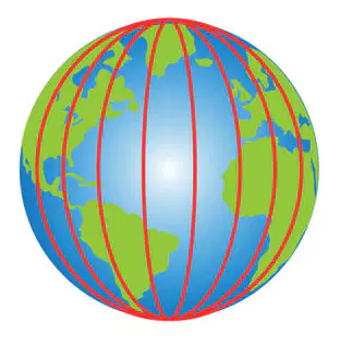
What is shown on the map? (HINT: THERE ARE TWO CORRECT ANSWERS!)
parallels
meridian
lines of longitude
lines of latitude
If you are describing a place by saying it is "north of the river and next to the school," which geographic concept are you using?
Relative location
Absolute location
Region
Movement
A student is asked to explain how people adapt to living in a desert environment. Which theme of geography are they being asked about?
Human-environment interaction
Place
Movement
Region
Which term refers to a system of imaginary lines that help us determine location?
grid
key
place
locator map
What is another name for a line of latitude?
parallel
meridian
region
scale bar
If you wanted to know how much space on a map represents real distance, which map feature would you use?
scale bar
title
grid
geography
A student is looking at a map and wants to understand what the different symbols and colors mean. Which part of the map should they look at?
key
Prime Meridian
place
region
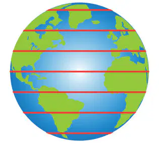
What is shown on the map? (HINT: THERE ARE TWO CORRECT ANSWERS!)
meridians
parallels
lines of latitude
lines of longitude
Imagine you are planning a trip and want to know how one city is positioned in relation to another. Which concept would you use to describe this?
relative location
locator map
title
parallel
The __________________ is an imaginary line at 0 degrees that runs from north to south.
Equator
Prime Meridian
parallel
map key
Which of the following best describes the function of a compass rose on a map?
It shows the different countries on a map.
It displays the directions (north, south, east, west) on a map.
It measures the distance between two points.
It marks the location of the equator.
What is the equator?
A line that runs from the North Pole to the South Pole.
A line that divides the Earth into Eastern and Western Hemispheres.
An imaginary line that divides the Earth into Northern and Southern Hemispheres.
A line that shows the location of the Prime Meridian.
What is a hemisphere?
A type of map used to show countries.
Half of the Earth, usually divided into Northern and Southern or Eastern and Western.
A tool used to measure distance on a map.
A line that runs parallel to the equator.
A globe is shown with a single horizontal line drawn around its widest part. What does this line represent?
The Prime Meridian
The Equator
A line of longitude
A line of latitude
Why is it important to know the difference between lines of latitude and lines of longitude when reading a map?
Because they help identify the type of map being used.
Because they help locate places accurately on the Earth's surface.
Because they show the population of different regions.
Because they indicate the climate of a region.
__________________ is an area that shares common features.
region
geography
map
area
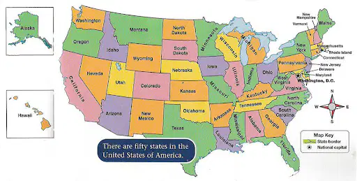
Which state is directly south of Kansas?
Nebraska
Missouri
Oklahoma
North Carolina

