
 Worksheets
Map Basics 2026-2027
Total questions: 20
Worksheet time: 20mins
Name
Class
Date
1.

What kind of map is this?
a)
weather
b)
product
c)
physical
d)
political
2.

What is the name of this line at 0 degrees latitude?
a)
Prime Meridian
b)
Equator
c)
North Pole
d)
South Pole
3.

What is the name of the line at zero degrees longitude?
a)
Equator
b)
Prime Meridian
c)
North Pole
d)
South Pole
4.

What is the approximate location of letter B?
a)
80oN, 0o
b)
0o, 80oW
c)
80oS, 0o
d)
0o, 80oE
5.
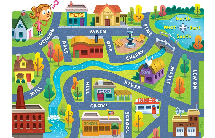
The school is ____ of the pet store.
a)
North
b)
South
c)
East
d)
West
6.
A map that shows boundaries of continents, countries, states, cities
a)
physical
b)
political
c)
thematic
d)
cultural
7.
A map that shows the physical shape of an area (mountains, lakes, rivers, etc.)
a)
physical
b)
political
c)
thematic
d)
cultural
8.

What is the red arrow pointing to?
a)
title
b)
scale
c)
symbols
d)
legend/key
9.

What is the yellow arrow pointing to?
a)
title
b)
scale
c)
symbols
d)
legend/key
10.

What is the purpose of this map?
a)
A physical map that shows where the mountains are
b)
A political map that shows the locations of all the states
c)
A special-purpose map that shows unemployment rates
d)
A special purpose map that shows climate activity
11.
Where would you find the symbol that indicates which city on the map is the capital city?
a)
map scale
b)
map legend
c)
map elevation
d)
map title
12.

What is this object known as?
a)
map symbol
b)
map key
c)
map scale
d)
compass rose
13.

Which city is located at 38 degrees north and 120 degrees west?
a)
San Fransisco
b)
New York
c)
New Orleans
d)
London
14.
If you were at 30 degrees south and 60 degrees west, which continent would you be in?
a)
Europe
b)
Africa
c)
South America
d)
Australia
15.
Which map is a 'political map'?
a)
b)
c)
d)
16.
What is represented by the "D" in the TODALS acronym for maps?
a)
Distance
b)
Direction
c)
Date
d)
Description
17.
Which of the following is NOT part of the TODALS map essentials?
a)
Title
b)
Orientation
c)
Distance
d)
Scale
18.

a)
The map shows lines of longitude.
b)
The map shows lines of latitude.
19.

If you were leaving the school and wanted to go to the park what direction would you go?
a)
North
b)
East
c)
West
d)
South
20.

What direction is indicated by the number 4? _
(a)
100 %

