
Font size
 Worksheets
U.S. Geography and Regions Test
Total questions: 27
Worksheet time: 19mins
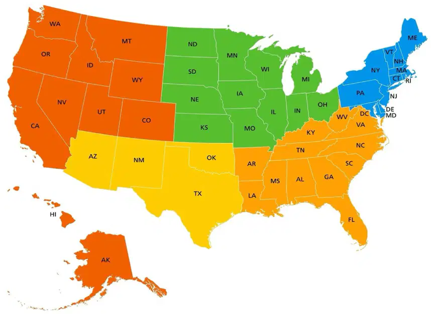
What U.S. Region is shown in red?
West
Southwest
Midwest
Northeast
Southeast
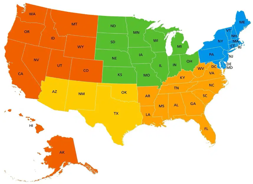
What U.S. Region is shown in green?
Midwest
Northeast
Southwest
Southeast
West
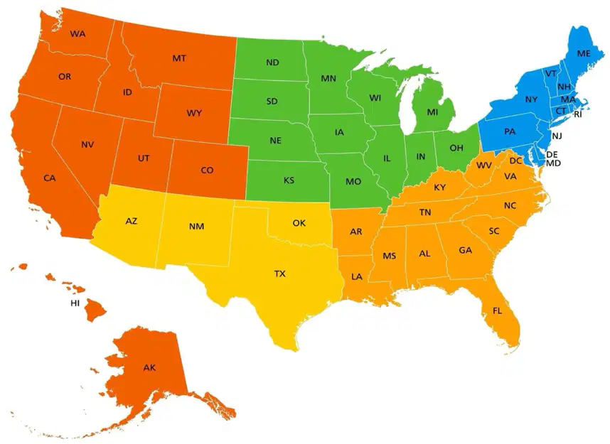
What U.S. Region is shown in yellow?
Southwest
Northeast
Midwest
Southeast
West
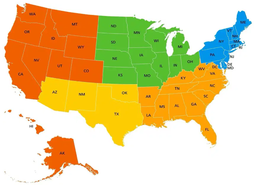
What U.S. Region is shown in blue?
Northeast
Midwest
Southwest
West
Southeast

What U.S. Region is shown in orange?
Southeast
Northeast
Midwest
Southwest
West
Which city is located in Texas and is home to the Johnson Space Center?
New York City
Los Angeles
Chicago
Houston
Phoenix
Which city is the largest in the United States and was created by people from the Netherlands in 1642?
New York City
Los Angeles
Chicago
Houston
Phoenix
Which city is able to move goods around because it is near lakes and rivers?
New York City
Los Angeles
Chicago
Houston
Phoenix
Which city would you want to live if you were trying to become a famous actor?
New York City
Los Angeles
Chicago
Houston
Phoenix
Which city relies on tourists visiting the Grand Canyon?
New York City
Los Angeles
Chicago
Houston
Phoenix
Which cities are located next to oceans or large bodies of water?
New York City
Los Angeles
Chicago
Houston
Phoenix
Which region is known for having dry deserts and little rainfall?
West
Midwest
Southwest
Southeast
Northeast
The Rocky Mountains are a major landform that is *mostly* in which region?
West
Midwest
Southwest
Southeast
Northeast
Which region has hot, humid summers and mild winters, with swamps and wetlands?
West
Midwest
Southwest
Southeast
Northeast
Tall grasses cover the Great Plains, which are mostly found in which region?
West
Midwest
Southwest
Southeast
Northeast
Which region has four distinct seasons, many deciduous forests, and is home to the Appalachian Mountains?
West
Midwest
Southwest
Southeast
Northeast
Which region has a variety of climates, from hot and dry deserts to cool and wet forests?
West
Midwest
Southwest
Southeast
Northeast
Which region has vegetation like cacti and shrubs and has deserts, mountain ranges, and canyons?
West
Midwest
Southwest
Southeast
Northeast
Which region has diverse vegetation from cacti and desert plants to dense forests of conifers and deciduous trees in the north?
West
Midwest
Southwest
Southeast
Northeast
Which region is known for its extensive wetlands including swamps, marshes and bogs, and dunes in its coastal areas?
West
Midwest
Southwest
Southeast
Northeast
Which region has a humid climate with hot summers and cold winters, and is known for experiencing extreme weather conditions such as tornadoes and blizzards?
West
Midwest
Southwest
Southeast
Northeast
Vocabulary Matching: Match the following terms with their correct definitions or related terms.
a simple map that shows the area in which an accompanying map is located
locator map
a map that shows information such as borders, capitals, and important cities
political map
a map that shows geographic feature of a place, such as mountains and valleys and bodies of water
physical map
a mpa that shows the distance or height above sea level of a land arap
elevation map
a mpa that shows a state's major natural and economic resources and where they're located
resources map
Vocabulary Matching: Match the vocabulary word to the correct definition
the usual pattern of weather in a place over a period of time
climate
an area that shares physical or human characteristics
region
a method of moving water from a source to where it is needed, such as for watering crops
irrigate
a natural feature of the earth
landform
the difference in elevation between the highest and lowest parts of an area
relief
Vocabulary Matching: match the vocabulary word to it's definition
the boxed list showing what the symbols or colors on a map represent
legend
a ruler that shows the distances on a map
scale
a mark, a drawing, or color on a map that stands for something else
symbol
a numbered and lettered rows of imaginary squares along the edges of a map
grid system
a map that shows a picture of what an area looks like from space
satellite map
Match the following
lines that measure the distance north and south from the equator
latitude
lines that measure the distances east and west of teh prime meridian
longitude
an area of flat land that is often covered with grass or trees
plain
a map that shows a state's major natural and economic resources and where they're located
resources map
Label the 5 most populous cities on the map.
Label the map with the following major physical features of the U.S.

